:::

【2020 Application Example】 AI Helps Establish the Best AOI Parameter Model for Passive Components, Reducing Production Costs of Over-Screened Components, Saving NT$2.5 million Annually

Traditional AOI uses limited sample images for inspection, facing the problem of high over-screening rates

In the electronic component manufacturing industry, AOI (Automated Optical Inspection) equipment is often used to measure defects in product appearance. For a long time, AOI measurement equipment has used limited sample images in image processing to compare the appearance of products from different external light sources and angles.

This comparison method can automatically screen for defects in product appearance. However, due to current technical limitations, there are often problems with light source parameter adjustment between product batches. If an inexperienced technician handles these adjustments, it will lead to a decrease in machine utilization rate and high over-screening rates.

The maturity of AI image machine learning has brought new opportunities for the AOI process

In terms of Taiwan's passive components, chip resistors and MLCC currently rank in the top two worldwide in terms of market share in 2019. In the long term, various car manufacturers have launched electric vehicles and smart vehicles, and various countries have also developed 5G-related equipment, which will further increase future shipments of passive components. Therefore, besides expanding new product lines, how to help existing products enhance their competitiveness will be the key to the industry's future international competition.

AOI inspection is one of the common stations in the passive component process, limited sample images are used in the current stage to compare the appearance. However, when switching between product batches, there are often problems with light source parameter adjustment, and the condition of these adjustments will affect the over-screening (mis-screening) of good products in each batch. In each batch of defective products in the industry, on average over-screening (mis-screening) occurs 20% of the time.

Relying on the guidance capabilities of the Southern Taiwan Industry Promotion Center, which has been deeply involved in Southern Taiwan for more than a decade, the company was matched with the AI image recognition technology unit of the Industrial Technology Research Institute (ITRI) to address the pain points of the passive component industry, reducing over-screening in the AOI process and also reduce errors caused by manual adjustment.

Using image recognition technology to reduce the occurrence of AOI over-screening

The technical unit of the ITRI that participated this time used image recognition technology to develop AOI technology for passive component processes in the establishment of AI modules.

In the development process, the company in this case first provided product appearance images and corresponding adjustment parameters, and then used the adjustment logic of current production line personnel to construct a product data set and further establish an AI model. When planning the production line test, the first priority is image recognition rate. Image detection and tag search are combined with comparison by an AI module to output AOI adjustment parameters for reference by online personnel.
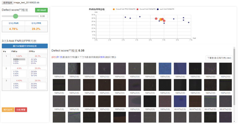
Image analysis diagram

▲Image analysis diagram

In the future, we also hope to use the help of machine learning to complete the AI learning curve for machine parameter adjustment, further reduce the over-screening rate of product appearance defect detection, simultaneously solve the gap in on-site professional and technical talent, and increase product yield.
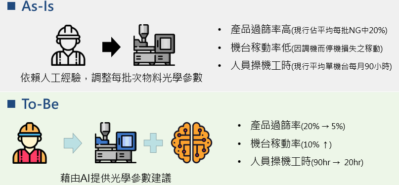
Before and after scenario of incorporating machine learning

▲ Scenarios before and after implementing machine learning

Implementing AI applications in processes to lay the foundation for developing unmanned factories

In the future, we hope the guidance of AI HUB will accelerate the application of advanced process technology and establish AI indicators for each station of the passive component process, which will help domestic production of high quality passive component products and increase product yields and prices. It will use innovative thinking to increase the added value of the industry and continue to lead the passive component industry forward.
Recommend Cases

【解決方案】佐翼科技無人機導入高爾夫球場域 可節省一半人力
Droxo Tech Applies Drones in Golf Courses to Reduce Manpower by Half

For most golf courses, the operations and management is a headache "Golf courses are selling turf and need to be properly taken care of," a golf course manager bluntly pointed out Facing the market pain points of labor shortage, aging population and high cost, the use of AI drones for pesticide spraying and pest control will reduce labor costs by more than half and greatly improve the overall operational efficiency At noon in early summer, an AI drone is slowly taking off at the Taipei Golf Club in Taoyuan Its main task is to test AI drone fertilizing and pesticide spraying on the golf course In fact, drones of Droxo Tech, the company performing this task, are widely used for fertilization, pesticide spraying, and pest and disease control for rice, bananas, and tea trees For golf courses with turfs that often cover tens to hundreds of hectares, AI drones are needed to assist in turf maintenance Data collection, development of pesticide spraying AI models, and multispectral image analysis and testing will be carried out in the current stage In the future, large-scale technology implementation and verification will be carried out to set an example for applying drones to golf courses Using AI drones to fertilize and spray pesticides can reduce the manpower required by half The traditional way of maintaining the turf in golf courses is to carry spray buckets or drive spraying vehicles to spray areas one by one "Domestic golf courses began to plant ultra-dwarf Bermuda grass in 2001 This grass species prefers a cool climate and is not suitable for Taiwan's hot and humid weather" Droxo Techrsquos CEO further pointed out that to prevent turf from pests and diseases, pesticide spraying is necessary For an 18-hole golf course, it is equivalent to spraying pesticides once a week, and the T-ground and fairways are sprayed every two months For golf courses, spraying pesticides is time-consuming and labor-intensive It is important to note that large-scale spraying will increase the risk of personnel poisoning and increase the amount of pesticide used Benefits of applying agricultural drones to golf courses According to Droxo Techrsquos research, golf course pests include Spodoptera litura, which comes out at night to look for food, so pesticide spraying must be carried out in the evening According to the traditional method, pesticide spraying requires two vehicles and three personnel for a total of 45 hours If AI drones are used for fertilizing and pesticide spraying, it only takes one operator to spray 08 hectares of land in 20 minutes, saving about two-thirds of the manpower and reducing operating costs by about 30 Using AI drones to fertilize and spray pesticides on golf courses can reduce the manpower required by half In addition to the significant benefits of using agricultural drones for golf course turf maintenance, Droxo Tech also specially introduced AI multispectral image recognition for NDVI Normalized Difference Vegetation Index analysis "The so-called multispectral is to direct light with different wavelengths on the turf, and the reflected images are collected for analysis" Droxo Tech CEO Liu continued to explain that each plant absorbs light with different wavelengths, so multispectral imaging can determine the growth status of grass species At the same time, combined with AI image recognition, the distribution of pests and diseases can be accurately detected, and the amount of pesticide used is determined on this basis Cross-domain collaboration to build a multi-source turf image databasenbsp Using AI multispectral image recognition technology, Droxo Tech will collect visible light, multispectral, thermal images, and hyperspectral images to establish a multi-source turf image database to fully understand the growth cycle of Bermuda grass Droxo Tech has accumulated rich experience in agricultural AI drone pesticide spraying , but there are still many problems that need to be overcome to implement AI solutions in golf courses For example, it is necessary to establish a new pesticide spraying model and test flight methods, especially the application of multispectral image recognition PoC is not difficult, but actual implementation requires more test evidence, repeated inferences, and collaboration with plant experts This part must rely on the cross-domain integration of legal entities such as the Institute for Information Technology III, gathering more fields for verification, and creating a paradigm before it can be more widely adopted by golf courses There are not many international cases on the application of AI drones in golf courses During the verification process, it is not yet known whether it can be quickly copied to the next golf course However, Droxo Tech CEO Liu believes that through cross-domain collaboration, clearly defining the problems and listing them one by one, supply and demand parties can reach a consensus, propose solutions to each problem, and seek cooperation with internal and external resources Only then will we be able to gradually achieve the goal of making golf courses smarter and smoothly assist the industry with transformation Zuoyi Technology's CEO, Liu Junlin 「Translated content is generated by ChatGPT and is for reference only Translation date:2024-05-19」

【導入案例】巨量遙測空間數據AI分析雲端服務平台 使衛星遙測影像順利落地應用
AI Analysis Cloud Service Platform for Remote Sensing Big Data Enables the Smooth Application of Satellite Remote Sensing Images

Although satellite remote sensing images can make all surface objects visible, it still requires a lot of time and manpower to be truly applied to the industry In order to effectively solve the problems that customers face in digesting huge amounts of image data and eliminate technical obstacles for cross-domain users to process satellite remote sensing images, ThinkTron has developed an "AI Analysis Cloud Service Platform for Remote Sensing Big Data" as a new beginning for cross-domain AI applications for spatial information In recent years, in response to the impact of industrial globalization, Taiwan's agriculture has continued to transition towards technology-based and higher quality, improving the yield and quality of crops by solving problems, such as microclimate impacts and pest and disease control The demand of agriculture on images has expanded endlessly to accurately grasp the growing environment of crops In the early years when UAVs unmanned aerial vehicles were not yet popular, manual field surveys were the most basic but most labor-intensive work With the emergence of UAV drones, aerial photography operations might not be difficult, but the range that can be photographed is limited Furthermore, surveying expertise is required to accurately capture spatial information At this time, the use of satellite remote sensing data may break away from the past imagination of using image data Taiwan Space Agency TASA ODC data warehouse services In the past ten years, with the breakthrough of modern satellite remote sensing application technology, Digital Earth has become a new trend in global data collection Countries have developed data cube image storage technology, and the development of smart agriculture has become one of the largest image users Determining planting distribution is the first step in understanding crop yields Free satellite remote sensing images, powerful data warehousing support, and the team's robust image recognition technology are important supports for accelerating agricultural transformation Using satellite remote sensing image data can accelerate the development of smart agriculture However, in the past, it was difficult to extract large-area crop distribution through satellite remote sensing images, not to mention the cost If you wanted to use free information, you had to visit all websites of international space agencies, look through the wide variety of satellite specifications, and carefully evaluate the sensor specifications, image resolution, and revisit cycle After finding suitable images, you had to look at them one by one to filter the ones you need Next is downloading dozens of images that are often several hundreds of Megabytes MB each, which might exceed the capacity of your computer Also, after overcoming image access and preparing data, you must then start to confirm the downloaded image products and which bands you want, because the image you see is not just an image file jpg or png, but rather complex multi-spectral information, attribute fields and coordinate information It takes a lot of effort just to confirm the correct information Facing GIS software packages with complex functions is the start of another trouble The complex image pre-processing process and the inflexible machine learning package greatly reduce the efficiency of analyzing data After finally getting the results of crop identification, you might find that the best time for using map information may have already passed The above-mentioned complex and time-consuming satellite image processing problems are precisely the pain points of the market ThinkTron expanded from traditional machine learning to modern deep learning applications, and developed an "AI Analysis Cloud Service Platform for Remote Sensing Big Data" under the GeoAI framework, breaking through the constraints of details in the spatial information for customers Differences between the process before and after introducing the AI analysis cloud service platform ThinkTron said that Taiwan's ODC Open Data Cube system has been completed and began providing services after years of efforts from the Taiwan Space Agency TASA, formally becoming aligned with international trends The powerful warehousing technology allows users to easily capture and use image data of a specific time and spatial range according to their needs The warehouse stores multiple satellite image resources from international space agencies, including the ESA's Sentinel-1 one image every 6 days, Sentinel-2 one image every 6 days, USGS's Landsat-7 one image every 16 days, Landsat-8 one image every 16 days, and the domestic Formosat-2 one image every day and Formosat-5 one image every 2 days ThinkTron develops satellite image recognition tools based on Python Breaking free from the limitations of GIS Geographic Information System software packages, ThinkTron integrated GDAL Geospatial Data Abstraction Library based on Python, and considered computing efficiency and parallel processing when developing all tools required for satellite image processing and image recognition modeling, including coordinate system and data format conversion, grid and vector data interaction, and data intra-difference and normalization All of the tools are designed with AI applications in mind, and some commonly used tools are packaged into an open source package under the name TronGisPy to benefit the technical community ThinkTron utilized the team's understanding of satellite remote sensing images and the collected tagged data crop distribution maps to preset the image recognition modeling process, the required training data specifications, and dataset definitions This is imported into the machine learning LightGBM or deep learning CNN framework that was completed in advance, and the entire training process to be performed in the Web GIS interface, providing users with partial flexibility to freely filter images, confirm spatial and temporal ranges, select models, and adjust hyperparameters In addition to the operation of training models, it also provides historical models to output identification results, and finally displays the identification results of crop distribution on the Web GIS map In fact, agriculture is not the only industry that needs satellite remote sensing applications AI applications of spatial information have also appeared in various fields as companies in different industries aim to enhance their global competitiveness For example, surveying and mapping companies that have a large amount of map data can use the AI analysis cloud service platform to store map data while also accelerating the efficiency of digital mapping Under the severe global climate change and the risk of strong earthquakes, there is a wide variety industrial insurance, agricultural insurance, financial insurance, or disaster insurance are all inseparable from spatial information The use of remote sensing image recognition to understand insurance targets has long been an international trend AI Analysis Cloud Service Architecture for Remote Sensing Big Data

這是一張圖片。 This is a picture.
[2023 Case Study] AI Steps into Philanthropy: Stylish Tech at Food Banks

Taiwan Food Bank AssociationHereinafter referred to as 'the Association'With the mission of providing food aid, poverty relief, reducing food waste, and building a hunger-free network, there are locations across Taiwan that gather donations from wholesalers, intermediaries, retailers, manufacturers, and even generous individuals These sites also rescue food that would otherwise be discarded, properly allocate and distribute it to needy households, thus aiding local vulnerable families55Food banks at various locations collect daily donations from wholesale stores, intermediaries, retailers, manufacturers, and even benevolent individuals from all over Taiwan These places also rescue about-to-be-discarded edible materials, properly sort them, and distribute to needy households, assisting local vulnerable populations However, each location requires significant human and volunteer resources to manage daily operations using traditional methods of communication with non-profit organizations and donors After receiving donations, these resources are then allocated to needy families or individuals There is a potential issue of uneven distribution of resources due to a lack of digitalization and integrated information management in these processes Warehouse and Transportation Centers and Mini Food Banks Distributing Resources to the Disadvantaged The location under validation by the Kaohsiung Charitable Organizations Association,Hereinafter referred to as 'Kaohsiung Charity' In109year6month24Officially inaugurated Taiwan's first 'Food Bank-Warehouse and Transportation Center' at a location measuring200square meters, enhancing the efficiency of food resource redistribution, proper storage, and management So far, nearly two hundred tons of vegetables and fruits have been saved, serving over a hundred organizations and benefiting over5thousand vulnerable households, and continues to serve19mini food banks, with planned completion across multiple districts in Kaohsiung, distributing food resources to over10ten thousand vulnerable families Kaohsiung Charity 'Food Bank-Warehouse and Transportation Center' in the Dasha Community Photo Source Kaohsiung Charitable Organizations Association Challenges in Labor and Food Resource Management Facing the needs of a large number of economically disadvantaged families, the management of the 'Food Bank-Warehouse and Transportation Center' is particularly critical During procurement, tasks such as sorting, purging, and bookkeeping must be performed, while during shipment, food resource needs suggested by social workers must be followed These activities rely on manual judgment and accumulated experience Many volunteers involved are elderly and have limited physical strength, making warehouse tasks physically demanding and recruitment challenging If a large batch of food resources arrives, space and manpower are consumed in sorting and inventory management, raising concerns about the effective use of resources and turnover rate This highlights the challenge of scaling up food bank services while lacking corresponding labor and material management systems At the same time, food bank resources come from various donations, thus they vary greatly in type, shelf life, standards, and quantity Volunteers at mini food banks, mostly also elderly, must handle multiple responsibilities such as case services, food resource management,resource allocation, and resource development Sometimes they must also explain and accept immediate, large quantities of specific resources, such as adults receiving baby formula 'Food Bank-Warehouse and Transportation Center' Resource Inventory Relies Entirely on Manual Labor Mini Food Bank Volunteers Handle Multiple Responsibilities Photo Source Taiwan Food Bank Association Reducing Scrap Resources60 Increasing Speed of Resource Transfer80 To enhance resource management and ensure effective use of materials, and to address personnel shortages, this field validation case has introduced 'Food Bank Warehouse Resource CollectionAITo advance resource management, ensure effective use of resources, and solve manpower shortages, this validation site has implemented an 'Automated Early Warning Needs Assessment System' for the food bank's warehouse resource gathering The first part involves building a classification model, setting up and collecting warehouse information at the site, andAItraining the model Past sitewarehouse information is collected and stored in a database, allowingAIfor preprocessing, classification, and other tasks At the same time, depending on the dependency conditions of the types of goods as features, algorithms are introduced for computation and modeling, and the data collected is used for retraining, ultimately validating the field and organizing data for the five most common types of goods into training and test datasets as required The second part involves constructing the classification model using AI techniques further use of reinforcement learning constructs the management mechanism for the food bank's warehouse, perfecting the classification of donated goodsRNNTechnical construction of classification models further use of reinforcement learning constructs food bank warehouse management mechanisms, making the classification of donated goods perfectlike white rice, instant drinks, noodles, instant noodles, and canned goodscan then be automatically assigned storage based on storage assignment principles AI Service System Process and Description Source Taiwan Food Bank Association AtAIUnder forecasts, it can optimize the speed of resource transfer and allocation, effectively and accurately match resource donations reducing the loss in the donation process, increase the accuracy of resource distribution, and improve the service rate—the successful donation rate—reducing the waste of resources due to incorrect items, and enabling instant monitoring of food resource stock, ensuring operators can respond quickly to needs, effectively providing resource assistance WithAIthe system's introduction and the establishment of data intelligence, it helps the operations of the warehouse and transportation center, allowing more time for the allocation of donated goods The introduction aims to accelerate the digital service rollout for social welfare organizations, thoroughly addressing the needs of the overall vulnerable segments of society Using the system for resource allocation and dispatching Photo Source Kaohsiung Charitable Organizations Association Following this field validation, it is possible to expand the system to other food bank service pointsAIThe system can also collaborate with more non-profit organizations, public welfare groups, and charitable organizations, expanding 'Food Bank Warehouse Resource CollectionAIAutomated Early Warning Demand Assessment System' application range such as medical supply distribution, helping more organizations manage and distribute more intelligently, reducing resource wastage, and enhancing social welfare 「Translated content is generated by ChatGPT and is for reference only Translation date:2024-12-12」