:::

【2020 Application Example】 AI Address Parsing, No More Hitting Walls in Searching for Coordinates

Empower addresses with spatial coordinates to help drive the 'Open Data' policy

In recent years, the government has been promoting 'Open Data' hoping that the openness of data will facilitate inter-agency data flow, enhance administrative efficiency, meet public needs, and strengthen public oversight of the government. Among them, transportation data is closely related to daily life, often reported by the public with the incidents specifying obvious local landmarks or addresses; there have also been public feedback about the traffic reports on police radio that lacked actual coordinates. Introducing these addresses, which were originally without spatial attributes, into the geographical coordinate system is one step toward 'Smart Spatial Decision Making'.

However, unstructured addresses, without manual intervention to improve the inconsistency of address formats, do not yield high location accuracy, necessitating an improvement in data quality and usability to unlock the potential applications of open data. This further aids in policy promotion and widespread application to different sectors including tourism, employment, birth and adoption.

Unregulated and diverse writing styles of addresses lead to low location accuracy

Address Locator is jointly developed by SongXu Information Co., Ltd. and YanDing Intelligent Co., Ltd. GOLiFE as a 'stand-alone address locating software' providing single or batch address location services. To imbue address data with spatial attributes, the core technology of Address Locator involves 'Address Parsing' and 'Address Location' in two stages. Initially, 'Address Parsing' distributes the addresses aimed for positioning according to administrative region hierarchy keywords: province/city, township/district, village, road/street, alley, lane, number; subsequently, 'Address Location' matches the split addresses with the parent address to obtain the location level and corresponding coordinates.

However, in the actual business integration process, since address sources are maintained separately by different authorities, a lack of consistent standards remains a common issue. Problems include: special characters (at address examples in specific regions), omitted administrative units, repetitive administrative hierarchical keywords, special street-alley segments, mismatch in Chinese numericals vs. Arabic numerals, and non-current addresses leading to complex address formats that are difficult to accurately split.

Establishing an address tokenization model, achieving precise location alignment!

To effectively handle various messy address formats and alleviate the difficulties in location alignment for the existing Address Locator, AI and Natural Language Processing technologies are implemented for 'Address Normalization' and a 'Chinese Tokenization Tool' to optimize existing address location capability. 'Address Normalization' addresses the issues of missing keywords, variant character forms, and missing administrative areas; whereas 'Chinese Tokenization Tool' helps resolve 'split errors' caused by special address formats, preventing unsuccessful positioning.

Successful address parsing through AI tokenization technology

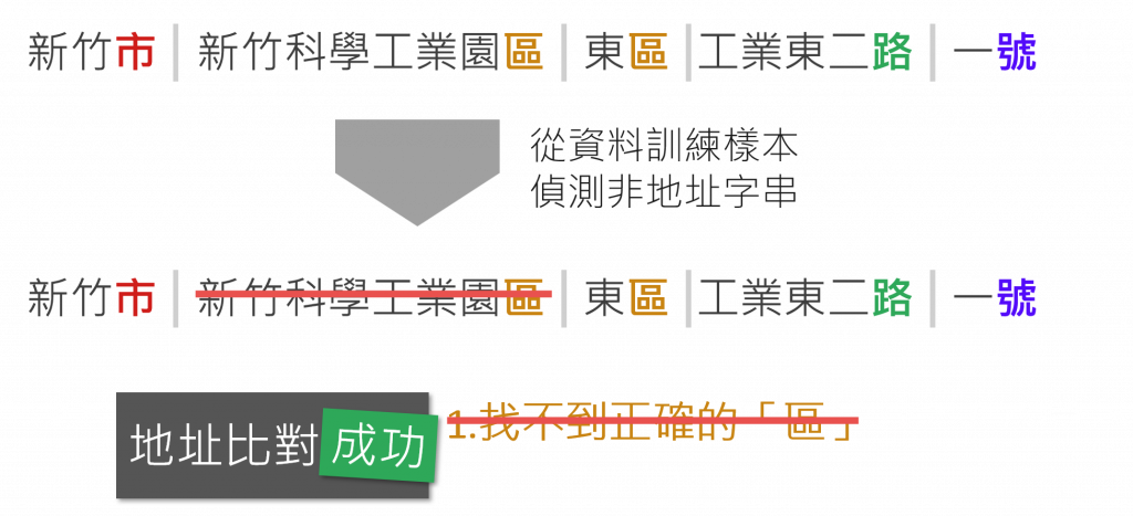
▲ Successful address parsing through AI tokenization technology

In the past, while handling address location services, manual preprocessing for data standardization was required, hence it was not solely marketed as a product, but included in project plans that offered address location services. However, after incorporating address normalization and AI tokenization technology, it has become a complete product, significantly reducing the time users spend on manual adjustments and achieving the intended location accuracy. Furthermore, the AI-enhanced Address Locator is now introduced on the SongXu Information Co. Ltd. website, including product descriptions and official listings.

After four months of testing and modifications, AI technology was successfully incorporated into the existing address location product. From selecting the tokenization tools, building the corpus, training the model, and interfacing with product features, to complete test planning, collection from 'Government Data Open Platform' and 'Taichung City Government Data Open Platform,' including over 62 datasets and more than 300,000 addresses, achieving a complete match rate of 90.08% and a fuzzy match rate of 98%, greatly surpassing the original product in match rates and processing time!

To promote AI technology applications in the information services sector, the AI-enhanced address location service is positioned as a new solution and showcased on the SongXu company website; starting from product function introductions, explaining address regularization methods and address location features; subsequently, guiding potential customers to envision applicable scenarios including: decision analytics, precision marketing, and other applications. The product will aid various sectors’ data by assigning spatial information to addresses, delving into the context and trends of data in two-dimensional space.

Address Location Solution

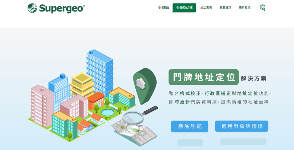
▲ Address Location Solution

Providing spatial coordinates for attractions, intersections, and points of interest

Successful development and implementation of AI-enhanced products in companies focused on smart transportation systems in the domestic market revealed that, while effectively solving address location issues, they also recognized that descriptions of spatial information, beyond addresses inclusive. During their progress, integrating AI more broadly into 'Entity Recognition' is set to be an important future application not limited to address location. In an era of information overload, collecting data is straightforward; identifying keywords of interest is key. Future development directions aim to optimize these products and create more business opportunities!

「Translated content is generated by ChatGPT and is for reference only. Translation date:2024-05-19」

Recommend Cases

【解決方案】優式AI智能割草機器人 搶攻高爾夫藍海市場
USRROBOT's AI Lawn Mowing Robot Enters the Blue Ocean of Golf Market

An AI smart lawn mowing robot, resembling a vacuum robot, shuttles back and forth on the 30-hectare golf course lawn for weeding This robot, independently developed and designed by Taiwanese, is equipped with the world's first electronic fencing positioning technology which utilizes high-precision GPS integrated with cloud AI computation to determine the most efficient mowing paths, targeting the lucrative blue ocean market of golf courses This AI lawn mowing robot was developed by USRROBOT, a Taiwanese startup established in 2019 Chao-Cheng Chen, the president of USRROBOT, once served as the executive vice president of one of the top five ODM tech companies in Taiwan, and specializes in software and hardware integration When he served as the chairman of the Service Robot Alliance, he knew that the service robot industry was bound grow rapidly due to declining birth rates and the growingly severe labor shortage New demand - The horticulture market is large and the has rigid demand "To develop the core technology of service robots, we must find rigid demand Looking at European and American countries, there is a shortage of labor, but demand for horticulture has increased, and there has been a long-term shortage of 7-10 of horticultural workers" Under this strong "rigid demand," Chao-Cheng Chen established USRROBOT, and the company's first product is the AI lawn mowing robot In terms of overseas markets, the United States is the world's largest horticulture market, accounting for 30-40 of the global output value It is estimated that there are about 1 million horticulture workers, but they have been experiencing a labor shortage of 7-10 in recent years and have not been able to improve the situation The main reasons for labor shortage are Aging population and gardening is a labor-intensive job, so young people don't want to do it Unlike in Taiwan, European and American countries attach great importance to lawn maintenance and have expressly stipulated in the law that heavy fines will be imposed for failing to mow the lawn Therefore, the AI lawn mowing robot has considerable market development potential The introduction of AI multi-device collaborative mowing sensor technology is expected to reduce the burden of staff maintaining the golf course The AI lawn mowing robot developed by USRROBOT is currently in its second generation Domestic universities and well-known art museums are using the latest model M1, and it is also being used by some world-renowned high-tech companies and well-known universities in the United States The company is currently involved in negotiations for subsequent business cooperation USRROBOT stated that the professional RTK system currently used can reduce the original GPS positioning error from tens of meters to about 2 centimeters, allowing the robot to move accurately outdoors After setting the boundaries, it can be easily operated using the app New application - Implementation in golf courses solves the problem of labor aging and shortage Chao-Cheng Chen further explained that the National Land Surveying and Mapping Center is a RTK service provider RTK provides the error reference map of the positioning point USRROBOT can access the positioning error value of a specific position through 4G Internet access The AI algorithm of USRROBOT reduces the general 10-20 m error of GPS to 2 cm After positioning, USRROBOT then uses six-axis accelerator positioning, gyroscopes, and wheel differential sensing devices for software and hardware integration Only by matching the wheel's movement pattern and the terrain can accurate mowing path planning be achieved The AI lawn mowing robot, which is 62 cm wide, 84 cm long, 46 cm high, and weighs only 25 kg, can set the mowing boundaries in the cloud It can avoid pools and sand pits through settings, using AI algorithms to automatically calculate the optimal path It is able to mow approximately 150 ping of grass in one hour The battery can be used continuously for more than 6 hours The battery life is currently the highest in the world In addition to general gardening companies, with the assistance of the AI project team of the Industrial Development Bureau, Ministry of Economic Affairs, USRROBOT's AI lawn mowing robot has been applied to golf course lawn mowing A well-known golf course located in Taiping District, Taichung City currently has a staff of 5 people who are responsible for the lawn, planting maintenance, and other landscape maintenance of the entire 30-hectare course However, the average age of staff is as high as 55 years old, and the golf course has been unable to recruit new staff members for a long time In view of the aging staff and the shortage of manpower, the golf course hopes to mitigate the impact with AI technology, and is therefore using AI multi-device collaborative mowing sensor technology, in hopes of reducing the burden of staff maintaining the golf course New challenges - Expert systems are needed to overcome difficulties with different grass species "This AI lawn mowing robot has low noise, low pollution, low labor costs, and is waterproof and anti-theft In the lawn mowing process, it can identify and avoid obstacles through ultrasonic sensors while maintaining mowing quality, maintaining aesthetic and consistent grass length" Chao-Cheng Chen went on to say that the most important part about golf courses is that the grass pattern should be beautiful and free from diseases and pests Based on the site survey, golf courses are mainly divided into three major areas green, fairway and rough There is no problem using the current mowing robot to mow the rough area, and it can overcome slopes within 20 degreesThe short grass in the fairway area may only be two centimeters long, and the grass types are also different, so the cutterhead design needs to be modifiedAs for the grass in the green area, the grass must be mowed close to the ground and maintained in a consistent direction because it affects the putting speed Many factors will affect the green index, and this part requires more research and testing The AI lawn mowing robot can identify and avoid obstacles through ultrasonic sensors while maintaining mowing quality The AI smart lawn mowing robot has a built-in camera that can be used to detect the health condition of the lawn Chao-Cheng Chen said that in the future, an expert system will also be introduced for early determination of whether there are diseases, pests in the lawn or whether there is sufficient moisture, and provide lawn health data analysis to customers, so that they can take preventive and response measures sooner to reduce disaster losses Chao-Cheng Chen, who is also a good golfer himself, said that golf has developed well in Taiwan However, due to weather factors, such as rainy and humid climate and typhoons, Taiwan's golf courses have harder soil and more potholes compared with top tier golf courses overseas If AI lawn mowing robots are to be widely introduced into golf courses, there are still many difficulties that must be overcome However, Taiwan's difficult terrain creates a good testing ground Once Taiwan can overcome the many problems and successfully introduce the robot, it will be able to expand to overseas markets and seize new market opportunities in a blue ocean Chao-Cheng Chen, President of USRROBOT nbsp

【導入案例】維繫遊艇王國美譽 嘉信遊艇導入國內第一套FRP複材超音波智慧檢測
Maintaining the reputation of the “Kingdom of Yachts” - Kha Shing Enterprise introduces the first domestic FRP ultrasonic smart inspection of composite materials

The Kaohsiung-based Kha Shing Enterprise Co, Ltd was established over 40 years ago, and is Taiwan's largest customized yacht company with customers all over America, Europe, Asia, and Australia, earning Taiwan the reputation of the "Kingdom of Yachts" Current FRP hull inspection still relies on traditional methods, such as visual inspection and knocking sounds, which is time-consuming and labor-intensive Kha Shing has applied PAUT array ultrasonic inspection to hull FRP composite materials for the first time, and combined it with AI to interpret ultrasound images, develop complete intelligent solutions, and create emerging markets for inspection companies Kha Shing Enterprise Co, Ltd was formerly Kha Shing Wood Industry Co, Ltd, and was a factory specializing in wood import in Kaohsiung Linhai Industrial Park when it was first established It began to design, manufacture, and sell yachts in 1977 After the second-generation successor of the company, President Kung Chun-Hao entered the company, he made a breakthrough in the previous manufacturing model that relied mainly on the skills of master craftsmen, introduced digital manufacturing to accelerate shipbuilding, and began to make larger yachts, ranking in the top 20 manufacturers worldwide among manufacturers of large yachts over 24 feet It also set a record of delivering 94 yachts within one year, earning Taiwan the reputation of "Kingdom of Yachts" Defect detection ensures yacht quality, using AI to replace humans to achieve higher efficiency Defect detection is very important to ensuring yacht quality At present, the yacht industry still uses very traditional defect detection methods The hull structure is usually made by hand lay-up or the vacuum infusion process, using visual inspection or knocking and the frequency of the sound to determine defects It requires time-consuming manual inspection If there are any defects, they must be reworked and repaired, and a gel coat subsequently sprayed The hull must be constructed in sections to facilitate inspection For large yachts over 24 meters long, construction in sections is very time-consuming and labor-intensive To shorten the time of the yacht manufacturing process, Kha Shing Enterprise will first carry out the gel coating process for the hull, and then perform the hand lay-on process The hull manufacturing process has two types of composite material test specimen structures In terms of 54-foot yacht hulls, the hull contains gel coat, core material, fiber and resin, and the total thickness is about 32cmplusmn01cm, which is twice the total thickness of FRP hull without core material of about 16cmplusmn01cm Defects such as incomplete impregnation of glass fiber or residual air bubbles between glass fiber and resin occasionally occur during the manufacturing process The types of defects include insufficient resin, voids, and delamination Once defects occur, the supply of hull materials will be insufficient and yacht delivery will be delayed Schematic diagram of types of FRP hull In order to solve this problem, Kha Shing Enterprise has engaged in technical cooperated with the metal materials industry and the AI technology industry, combining the ultrasonic inspection expertise of the metal materials industry with AI technologies developed by the AI technology industry in recent years to help solve issues of Kha Shing Enterprise with defect detection The method uses PAUT on the composite material structure of yachts, conducts FRP ultrasonic evaluation to determine the thickness of the yacht hull and material properties, and evaluates the ultrasonic probe frequency applicable to the hull structure based on professional ultrasonic experience After testing, a frequency of 5MHz and a probe width of 45mm can successfully find the location and size of defects in the simulated defect test specimen The three parties jointly found defect detection solutions from array ultrasonic evaluation, AI technology model development, and actual application in yachts The image inspected is an ultrasound image The image displays different colors based on the ultrasonic feedback signal An AI model that automatically identifies defective parts is established through the YOLO algorithm If the amount of abnormal data collected is insufficient for training, the CNN-based Autoencoder algorithm is used to collect normal image data for training and construct an AI model for abnormality detection The object detection YOLO model is trained by inputting image data marked as having defects, while the abnormality detection model is trained by inputting image data without defects Simulated defective specimen corresponding to PAUT results Defect detection by and AI system can shorten the construction period by 15 months and speed up determination by 50 After the development of this AI system is completed, it will be validated on actual 54-foot yachts of Kha Shing Enterprise, and can effectively resolve issues with defects The application of AI technology in ultrasonic inspection for intelligent determination is expected to accelerate determination by approximately 50, and will also shortens the construction period by 15 months, effectively improving the speed and quality of the yacht manufacturing process As Taiwan develops larger and more refined yachts, it will create opportunities for industry optimization and transformation, as well as opportunities for the development of key technologies The application of an AI ultrasonic inspection solution for composite materials is the first of its kind in the yacht industry, and is expected to attract more yacht manufacturers with inspection needs The AI ultrasonic inspection solution for composite materials has three major competitive advantages 1 Professional inspection experience and digital database to facilitate process management and analysis 2 Automatic AI determination and identification quickly identifies defects and provides immediate feedback to process engineers 3 High-efficiency process inspection provides defect repair recommendations, reduces damage rate, and improves the strength and quality of composite materials The application of AI technology can optimize the yacht manufacturing process, reduce manual inspection, create added value through the application of AI in Taiwanrsquos yacht industry, increase international purchase orders, and allow Taiwan yachts to continue to enjoy a good reputation in the world Furthermore, this business model has also spread to fields of application related to composite materials, increasing cross-sector market usage It is estimated to contribute approximately NT14 to NT2 billion in economic benefits to Taiwan's equipment maintenance and non-destructive testing market

【導入案例】巨量遙測空間數據AI分析雲端服務平台 使衛星遙測影像順利落地應用
AI Analysis Cloud Service Platform for Remote Sensing Big Data Enables the Smooth Application of Satellite Remote Sensing Images

Although satellite remote sensing images can make all surface objects visible, it still requires a lot of time and manpower to be truly applied to the industry In order to effectively solve the problems that customers face in digesting huge amounts of image data and eliminate technical obstacles for cross-domain users to process satellite remote sensing images, ThinkTron has developed an "AI Analysis Cloud Service Platform for Remote Sensing Big Data" as a new beginning for cross-domain AI applications for spatial information In recent years, in response to the impact of industrial globalization, Taiwan's agriculture has continued to transition towards technology-based and higher quality, improving the yield and quality of crops by solving problems, such as microclimate impacts and pest and disease control The demand of agriculture on images has expanded endlessly to accurately grasp the growing environment of crops In the early years when UAVs unmanned aerial vehicles were not yet popular, manual field surveys were the most basic but most labor-intensive work With the emergence of UAV drones, aerial photography operations might not be difficult, but the range that can be photographed is limited Furthermore, surveying expertise is required to accurately capture spatial information At this time, the use of satellite remote sensing data may break away from the past imagination of using image data Taiwan Space Agency TASA ODC data warehouse services In the past ten years, with the breakthrough of modern satellite remote sensing application technology, Digital Earth has become a new trend in global data collection Countries have developed data cube image storage technology, and the development of smart agriculture has become one of the largest image users Determining planting distribution is the first step in understanding crop yields Free satellite remote sensing images, powerful data warehousing support, and the team's robust image recognition technology are important supports for accelerating agricultural transformation Using satellite remote sensing image data can accelerate the development of smart agriculture However, in the past, it was difficult to extract large-area crop distribution through satellite remote sensing images, not to mention the cost If you wanted to use free information, you had to visit all websites of international space agencies, look through the wide variety of satellite specifications, and carefully evaluate the sensor specifications, image resolution, and revisit cycle After finding suitable images, you had to look at them one by one to filter the ones you need Next is downloading dozens of images that are often several hundreds of Megabytes MB each, which might exceed the capacity of your computer Also, after overcoming image access and preparing data, you must then start to confirm the downloaded image products and which bands you want, because the image you see is not just an image file jpg or png, but rather complex multi-spectral information, attribute fields and coordinate information It takes a lot of effort just to confirm the correct information Facing GIS software packages with complex functions is the start of another trouble The complex image pre-processing process and the inflexible machine learning package greatly reduce the efficiency of analyzing data After finally getting the results of crop identification, you might find that the best time for using map information may have already passed The above-mentioned complex and time-consuming satellite image processing problems are precisely the pain points of the market ThinkTron expanded from traditional machine learning to modern deep learning applications, and developed an "AI Analysis Cloud Service Platform for Remote Sensing Big Data" under the GeoAI framework, breaking through the constraints of details in the spatial information for customers Differences between the process before and after introducing the AI analysis cloud service platform ThinkTron said that Taiwan's ODC Open Data Cube system has been completed and began providing services after years of efforts from the Taiwan Space Agency TASA, formally becoming aligned with international trends The powerful warehousing technology allows users to easily capture and use image data of a specific time and spatial range according to their needs The warehouse stores multiple satellite image resources from international space agencies, including the ESA's Sentinel-1 one image every 6 days, Sentinel-2 one image every 6 days, USGS's Landsat-7 one image every 16 days, Landsat-8 one image every 16 days, and the domestic Formosat-2 one image every day and Formosat-5 one image every 2 days ThinkTron develops satellite image recognition tools based on Python Breaking free from the limitations of GIS Geographic Information System software packages, ThinkTron integrated GDAL Geospatial Data Abstraction Library based on Python, and considered computing efficiency and parallel processing when developing all tools required for satellite image processing and image recognition modeling, including coordinate system and data format conversion, grid and vector data interaction, and data intra-difference and normalization All of the tools are designed with AI applications in mind, and some commonly used tools are packaged into an open source package under the name TronGisPy to benefit the technical community ThinkTron utilized the team's understanding of satellite remote sensing images and the collected tagged data crop distribution maps to preset the image recognition modeling process, the required training data specifications, and dataset definitions This is imported into the machine learning LightGBM or deep learning CNN framework that was completed in advance, and the entire training process to be performed in the Web GIS interface, providing users with partial flexibility to freely filter images, confirm spatial and temporal ranges, select models, and adjust hyperparameters In addition to the operation of training models, it also provides historical models to output identification results, and finally displays the identification results of crop distribution on the Web GIS map In fact, agriculture is not the only industry that needs satellite remote sensing applications AI applications of spatial information have also appeared in various fields as companies in different industries aim to enhance their global competitiveness For example, surveying and mapping companies that have a large amount of map data can use the AI analysis cloud service platform to store map data while also accelerating the efficiency of digital mapping Under the severe global climate change and the risk of strong earthquakes, there is a wide variety industrial insurance, agricultural insurance, financial insurance, or disaster insurance are all inseparable from spatial information The use of remote sensing image recognition to understand insurance targets has long been an international trend AI Analysis Cloud Service Architecture for Remote Sensing Big Data