:::

【2022 Application Example】 Droxo Tech Applies Drones in Golf Courses to Reduce Manpower by Half

For most golf courses, the operations and management is a headache. "Golf courses are selling turf and need to be properly taken care of," a golf course manager bluntly pointed out. Facing the market pain points of labor shortage, aging population and high cost, the use of AI drones for pesticide spraying and pest control will reduce labor costs by more than half and greatly improve the overall operational efficiency.

At noon in early summer, an AI drone is slowly taking off at the Taipei Golf Club in Taoyuan. Its main task is to test AI drone fertilizing and pesticide spraying on the golf course. In fact, drones of Droxo Tech, the company performing this task, are widely used for fertilization, pesticide spraying, and pest and disease control for rice, bananas, and tea trees. For golf courses with turfs that often cover tens to hundreds of hectares, AI drones are needed to assist in turf maintenance. Data collection, development of pesticide spraying AI models, and multispectral image analysis and testing will be carried out in the current stage. In the future, large-scale technology implementation and verification will be carried out to set an example for applying drones to golf courses.

Using AI drones to fertilize and spray pesticides can reduce the manpower required by half

The traditional way of maintaining the turf in golf courses is to carry spray buckets or drive spraying vehicles to spray areas one by one. "Domestic golf courses began to plant ultra-dwarf Bermuda grass in 2001. This grass species prefers a cool climate and is not suitable for Taiwan's hot and humid weather." Droxo Tech’s CEO further pointed out that to prevent turf from pests and diseases, pesticide spraying is necessary. For an 18-hole golf course, it is equivalent to spraying pesticides once a week, and the T-ground and fairways are sprayed every two months. For golf courses, spraying pesticides is time-consuming and labor-intensive. It is important to note that large-scale spraying will increase the risk of personnel poisoning and increase the amount of pesticide used.

The benefits of agricultural drones in golf course applications.

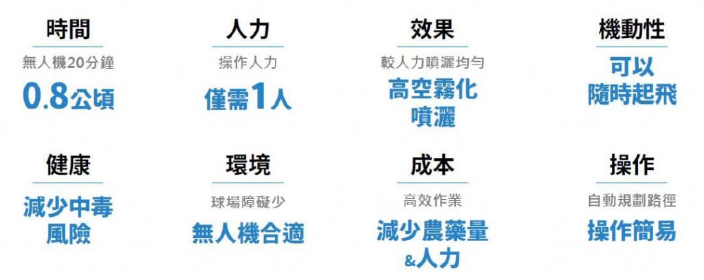
▲Benefits of applying agricultural drones to golf courses

According to Droxo Tech’s research, golf course pests include Spodoptera litura, which comes out at night to look for food, so pesticide spraying must be carried out in the evening. According to the traditional method, pesticide spraying requires two vehicles and three personnel for a total of 4.5 hours. If AI drones are used for fertilizing and pesticide spraying, it only takes one operator to spray 0.8 hectares of land in 20 minutes, saving about two-thirds of the manpower and reducing operating costs by about 30%.

Golf course lawns can save about half the workforce through AI drone fertilization and pesticide spraying.

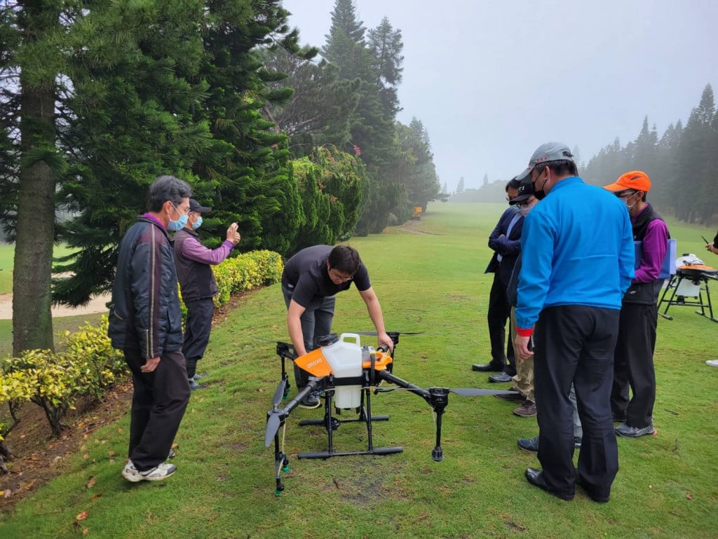
▲Using AI drones to fertilize and spray pesticides on golf courses can reduce the manpower required by half

In addition to the significant benefits of using agricultural drones for golf course turf maintenance, Droxo Tech also specially introduced AI multispectral image recognition for NDVI (Normalized Difference Vegetation Index) analysis. "The so-called multispectral is to direct light with different wavelengths on the turf, and the reflected images are collected for analysis." Droxo Tech CEO Liu continued to explain that each plant absorbs light with different wavelengths, so multispectral imaging can determine the growth status of grass species. At the same time, combined with AI image recognition, the distribution of pests and diseases can be accurately detected, and the amount of pesticide used is determined on this basis.

Cross-domain collaboration to build a multi-source turf image database 

Using AI multispectral image recognition technology, Droxo Tech will collect visible light, multispectral, thermal images, and hyperspectral images to establish a multi-source turf image database to fully understand the growth cycle of Bermuda grass. Droxo Tech has accumulated rich experience in agricultural AI drone pesticide spraying , but there are still many problems that need to be overcome to implement AI solutions in golf courses. For example, it is necessary to establish a new pesticide spraying model and test flight methods, especially the application of multispectral image recognition. PoC is not difficult, but actual implementation requires more test evidence, repeated inferences, and collaboration with plant experts. This part must rely on the cross-domain integration of legal entities such as the Institute for Information Technology (III), gathering more fields for verification, and creating a paradigm before it can be more widely adopted by golf courses.

There are not many international cases on the application of AI drones in golf courses. During the verification process, it is not yet known whether it can be quickly copied to the next golf course. However, Droxo Tech CEO Liu believes that through cross-domain collaboration, clearly defining the problems and listing them one by one, supply and demand parties can reach a consensus, propose solutions to each problem, and seek cooperation with internal and external resources. Only then will we be able to gradually achieve the goal of making golf courses smarter and smoothly assist the industry with transformation.

Zuoyi Technology's CEO, Liu Junlin.

▲Zuoyi Technology's CEO, Liu Junlin

「Translated content is generated by ChatGPT and is for reference only. Translation date:2024-05-19」

Recommend Cases

【導入案例】巨量遙測空間數據AI分析雲端服務平台 使衛星遙測影像順利落地應用
AI Analysis Cloud Service Platform for Remote Sensing Big Data Enables the Smooth Application of Satellite Remote Sensing Images

Although satellite remote sensing images can make all surface objects visible, it still requires a lot of time and manpower to be truly applied to the industry In order to effectively solve the problems that customers face in digesting huge amounts of image data and eliminate technical obstacles for cross-domain users to process satellite remote sensing images, ThinkTron has developed an "AI Analysis Cloud Service Platform for Remote Sensing Big Data" as a new beginning for cross-domain AI applications for spatial information In recent years, in response to the impact of industrial globalization, Taiwan's agriculture has continued to transition towards technology-based and higher quality, improving the yield and quality of crops by solving problems, such as microclimate impacts and pest and disease control The demand of agriculture on images has expanded endlessly to accurately grasp the growing environment of crops In the early years when UAVs unmanned aerial vehicles were not yet popular, manual field surveys were the most basic but most labor-intensive work With the emergence of UAV drones, aerial photography operations might not be difficult, but the range that can be photographed is limited Furthermore, surveying expertise is required to accurately capture spatial information At this time, the use of satellite remote sensing data may break away from the past imagination of using image data Taiwan Space Agency TASA ODC data warehouse services In the past ten years, with the breakthrough of modern satellite remote sensing application technology, Digital Earth has become a new trend in global data collection Countries have developed data cube image storage technology, and the development of smart agriculture has become one of the largest image users Determining planting distribution is the first step in understanding crop yields Free satellite remote sensing images, powerful data warehousing support, and the team's robust image recognition technology are important supports for accelerating agricultural transformation Using satellite remote sensing image data can accelerate the development of smart agriculture However, in the past, it was difficult to extract large-area crop distribution through satellite remote sensing images, not to mention the cost If you wanted to use free information, you had to visit all websites of international space agencies, look through the wide variety of satellite specifications, and carefully evaluate the sensor specifications, image resolution, and revisit cycle After finding suitable images, you had to look at them one by one to filter the ones you need Next is downloading dozens of images that are often several hundreds of Megabytes MB each, which might exceed the capacity of your computer Also, after overcoming image access and preparing data, you must then start to confirm the downloaded image products and which bands you want, because the image you see is not just an image file jpg or png, but rather complex multi-spectral information, attribute fields and coordinate information It takes a lot of effort just to confirm the correct information Facing GIS software packages with complex functions is the start of another trouble The complex image pre-processing process and the inflexible machine learning package greatly reduce the efficiency of analyzing data After finally getting the results of crop identification, you might find that the best time for using map information may have already passed The above-mentioned complex and time-consuming satellite image processing problems are precisely the pain points of the market ThinkTron expanded from traditional machine learning to modern deep learning applications, and developed an "AI Analysis Cloud Service Platform for Remote Sensing Big Data" under the GeoAI framework, breaking through the constraints of details in the spatial information for customers Differences between the process before and after introducing the AI analysis cloud service platform ThinkTron said that Taiwan's ODC Open Data Cube system has been completed and began providing services after years of efforts from the Taiwan Space Agency TASA, formally becoming aligned with international trends The powerful warehousing technology allows users to easily capture and use image data of a specific time and spatial range according to their needs The warehouse stores multiple satellite image resources from international space agencies, including the ESA's Sentinel-1 one image every 6 days, Sentinel-2 one image every 6 days, USGS's Landsat-7 one image every 16 days, Landsat-8 one image every 16 days, and the domestic Formosat-2 one image every day and Formosat-5 one image every 2 days ThinkTron develops satellite image recognition tools based on Python Breaking free from the limitations of GIS Geographic Information System software packages, ThinkTron integrated GDAL Geospatial Data Abstraction Library based on Python, and considered computing efficiency and parallel processing when developing all tools required for satellite image processing and image recognition modeling, including coordinate system and data format conversion, grid and vector data interaction, and data intra-difference and normalization All of the tools are designed with AI applications in mind, and some commonly used tools are packaged into an open source package under the name TronGisPy to benefit the technical community ThinkTron utilized the team's understanding of satellite remote sensing images and the collected tagged data crop distribution maps to preset the image recognition modeling process, the required training data specifications, and dataset definitions This is imported into the machine learning LightGBM or deep learning CNN framework that was completed in advance, and the entire training process to be performed in the Web GIS interface, providing users with partial flexibility to freely filter images, confirm spatial and temporal ranges, select models, and adjust hyperparameters In addition to the operation of training models, it also provides historical models to output identification results, and finally displays the identification results of crop distribution on the Web GIS map In fact, agriculture is not the only industry that needs satellite remote sensing applications AI applications of spatial information have also appeared in various fields as companies in different industries aim to enhance their global competitiveness For example, surveying and mapping companies that have a large amount of map data can use the AI analysis cloud service platform to store map data while also accelerating the efficiency of digital mapping Under the severe global climate change and the risk of strong earthquakes, there is a wide variety industrial insurance, agricultural insurance, financial insurance, or disaster insurance are all inseparable from spatial information The use of remote sensing image recognition to understand insurance targets has long been an international trend AI Analysis Cloud Service Architecture for Remote Sensing Big Data

【解決方案】佐翼科技無人機導入高爾夫球場域 可節省一半人力
Droxo Tech Applies Drones in Golf Courses to Reduce Manpower by Half

For most golf courses, the operations and management is a headache "Golf courses are selling turf and need to be properly taken care of," a golf course manager bluntly pointed out Facing the market pain points of labor shortage, aging population and high cost, the use of AI drones for pesticide spraying and pest control will reduce labor costs by more than half and greatly improve the overall operational efficiency At noon in early summer, an AI drone is slowly taking off at the Taipei Golf Club in Taoyuan Its main task is to test AI drone fertilizing and pesticide spraying on the golf course In fact, drones of Droxo Tech, the company performing this task, are widely used for fertilization, pesticide spraying, and pest and disease control for rice, bananas, and tea trees For golf courses with turfs that often cover tens to hundreds of hectares, AI drones are needed to assist in turf maintenance Data collection, development of pesticide spraying AI models, and multispectral image analysis and testing will be carried out in the current stage In the future, large-scale technology implementation and verification will be carried out to set an example for applying drones to golf courses Using AI drones to fertilize and spray pesticides can reduce the manpower required by half The traditional way of maintaining the turf in golf courses is to carry spray buckets or drive spraying vehicles to spray areas one by one "Domestic golf courses began to plant ultra-dwarf Bermuda grass in 2001 This grass species prefers a cool climate and is not suitable for Taiwan's hot and humid weather" Droxo Techrsquos CEO further pointed out that to prevent turf from pests and diseases, pesticide spraying is necessary For an 18-hole golf course, it is equivalent to spraying pesticides once a week, and the T-ground and fairways are sprayed every two months For golf courses, spraying pesticides is time-consuming and labor-intensive It is important to note that large-scale spraying will increase the risk of personnel poisoning and increase the amount of pesticide used Benefits of applying agricultural drones to golf courses According to Droxo Techrsquos research, golf course pests include Spodoptera litura, which comes out at night to look for food, so pesticide spraying must be carried out in the evening According to the traditional method, pesticide spraying requires two vehicles and three personnel for a total of 45 hours If AI drones are used for fertilizing and pesticide spraying, it only takes one operator to spray 08 hectares of land in 20 minutes, saving about two-thirds of the manpower and reducing operating costs by about 30 Using AI drones to fertilize and spray pesticides on golf courses can reduce the manpower required by half In addition to the significant benefits of using agricultural drones for golf course turf maintenance, Droxo Tech also specially introduced AI multispectral image recognition for NDVI Normalized Difference Vegetation Index analysis "The so-called multispectral is to direct light with different wavelengths on the turf, and the reflected images are collected for analysis" Droxo Tech CEO Liu continued to explain that each plant absorbs light with different wavelengths, so multispectral imaging can determine the growth status of grass species At the same time, combined with AI image recognition, the distribution of pests and diseases can be accurately detected, and the amount of pesticide used is determined on this basis Cross-domain collaboration to build a multi-source turf image databasenbsp Using AI multispectral image recognition technology, Droxo Tech will collect visible light, multispectral, thermal images, and hyperspectral images to establish a multi-source turf image database to fully understand the growth cycle of Bermuda grass Droxo Tech has accumulated rich experience in agricultural AI drone pesticide spraying , but there are still many problems that need to be overcome to implement AI solutions in golf courses For example, it is necessary to establish a new pesticide spraying model and test flight methods, especially the application of multispectral image recognition PoC is not difficult, but actual implementation requires more test evidence, repeated inferences, and collaboration with plant experts This part must rely on the cross-domain integration of legal entities such as the Institute for Information Technology III, gathering more fields for verification, and creating a paradigm before it can be more widely adopted by golf courses There are not many international cases on the application of AI drones in golf courses During the verification process, it is not yet known whether it can be quickly copied to the next golf course However, Droxo Tech CEO Liu believes that through cross-domain collaboration, clearly defining the problems and listing them one by one, supply and demand parties can reach a consensus, propose solutions to each problem, and seek cooperation with internal and external resources Only then will we be able to gradually achieve the goal of making golf courses smarter and smoothly assist the industry with transformation Zuoyi Technology's CEO, Liu Junlin 「Translated content is generated by ChatGPT and is for reference only Translation date:2024-05-19」

【導入案例】海量數位工程AOI機器智能手臂檢測系統 大幅提高瑕疵檢測精準度
Massive Digital Engineering AOI Intelligent Robotic Arm Inspection System Significantly Improves Defect Detection Accuracy

Taiwan is known as a manufacturing powerhouse, yet quality defect detection has always been a chronic sore point in production lines While AOI equipment is available to assist, most use fixed machinery which are limited by angles, resulting in less precise diagnostics and high false positive rates Massive Digital Engineering introduced an AOI intelligent robotic arm detection system that effectively reduces false positives and increases the accuracy of defect detection Generally, the yield rate of products affects the costs for enterprises and the return rate for customers The quality defect detection process in the manufacturing industry often necessitates a substantial amount of quality inspection labor Although there is AOI equipment to assist, these tools are mostly fixed detection machines Fixed cameras are easily limited by angles, resulting in less precise diagnostics and high false positive rates Thus, personnel need to re-screen and inspect afterwards, often manually visual inspection misses defects on average about 5, and can be as high as 20 Three major pain points in manufacturing quality detection Robotic Arm AOI with dynamic multi-angle inspection helps to solve these issues According to the practical understanding by Massive Digital Engineering, there are three main pain points in detecting product quality within the manufacturing industry Pain point one, manual inspection of product quality is prone to errors Currently, the manufacturing industry largely relies on human labor to inspect product appearance, but human judgment often entails errors, such as surface scratches, color differences, solder appearance, etc The error rate in defect judgment is high, and can only be inspected at the finished product stage, often leading to whole batch rejections and high costs in labor and production Pain point two, inability to quantify and record data from quality inspections Traditional manual inspections do not maintain inspection data, which makes it difficult to assign responsibility when quality disputes occur Moreover, high-end contract manufacturing orders from overseas brands often require traceability and corresponding defect records, which traditional human inspection methods struggle to meet Pain point three, limitations of traditional AOI visual inspection systems Current manufacturing uses AOI visual inspection systems, which due to the limitations of visual software technology, employ fixed cameras, fixed lighting, and single-angle operations This method may handle flat or linear-shaped products like rectangular or square items at a single inspection point However, it is more challenging to implement for products with complex shapes eg, irregular automotive parts, requiring multi-point and multi-degree inspections Massive Digital Engineering developed an AOI intelligent robotic arm detection system, effectively improving the accuracy of defect detection To address the pain points in quality inspection in manufacturing, Massive Digital Engineering initiated the concept of developing a multi-angle, movable inspection device, starting with the combination of two representative technologies in factory automation - robotic arms and machine vision By integrating robotic arms with AOI for dynamic multi-angle AI real-time quality inspection, the limitations of fixed inspection systems are addressed, and visual inspection techniques are enhanced by leveraging artificial intelligence, further elevating the sampling of images from flat to multi-dimensional and multi-angular Selected the automotive industry as the real-world testing ground to quickly respond to customer needs The AOI intelligent robotic arm detection system, utilizing AI technology including unsupervised learning, supervised learning, and semi-supervised learning, allows operators to use unsupervised deep learning techniques to learn about good products even when initial samples are incomplete or there are no defective samples, applying it in the visual inspection of automatic welding of car trusses This can solve issues of limited angles with fixed machinery before implementation, less precise diagnostics, and high false positive rates Automotive components are high in unit price and demand a stricter defect detection accuracy In industries that have adopted AI services, the automotive manufacturing sector was chosen as the real-world testing ground Massive Digital Engineering states that the automotive industry mainly consists of related component manufacturers and components typically have a higher unit price, hence requiring more in terms of quality inspection and yield rates, and demanding stricter accuracy Therefore, the automotive sector was chosen as the area for introduction By using a robotic arm combined with AI for dynamic multi-angle AOI visual real-time quality inspection, not only can the defect quality error rate of automotive components be improved, but the fixed-point AOI optical inspection can be enhanced to meet the measurement needs of most industries and finally, establishing a third-party system platform to build an integrated monitoring system platform, enabling immediate response and action when issues arise This system allows for recording and storing important data of products leaving the factory, serving as a basis for future digital production lines and virtual production At the same time, in the event of defects, it can immediately connect to Massive's MES monitoring system, quickly responding to the relevant manufacturing decision-making department, subsequently utilizing ERP systems for project management and reviews, effectively improving production efficiency and reducing production costs Helps to reduce communication costs and aims to become an industry standard In terms of industry integration, it provides a foundational standard for data continuity among upstream and downstream businesses, reducing communication costs within the supply chain Through certification of the contract manufacturers and brand owners, there is a chance to become the industry standard configuration Through the data database established by this project, operators can further optimize their supply chain management solutions using big data analysis Data Analysis, based on data, establish forecast planning, and utilizing technology to link upstream and downstream data of the supply chain, accurately controlling product quality In the future, when interfacing with European, American, and Japanese markets, which demand highly fine-tuned orders, operators can respond and integrate the industry supply chain Supply Chain more swiftly Ultimately, through the benchmark demonstration industry's field verification, such as with the automotive component manufacturing industry used as the benchmark demonstration field, by implementing the robotic arm combined with AI for dynamic multi-angle AOI visual real-time quality inspection system project, the supply chain connection between automotive contract manufacturers and OEMs can be optimized, becoming the industry standard Further seeking more AI teams to join the cross-industry development on the field collaboration platform, driving the overall ecosystem combining AI innovation with field application Self-driving vehicle developed by Massive Digital Engineering「Translated content is generated by ChatGPT and is for reference only Translation date:2024-05-19」