:::

【2020 Application Example】 AI Helps Establish the Best AOI Parameter Model for Passive Components, Reducing Production Costs of Over-Screened Components, Saving NT$2.5 million Annually

Traditional AOI uses limited sample images for inspection, facing the problem of high over-screening rates

In the electronic component manufacturing industry, AOI (Automated Optical Inspection) equipment is often used to measure defects in product appearance. For a long time, AOI measurement equipment has used limited sample images in image processing to compare the appearance of products from different external light sources and angles.

This comparison method can automatically screen for defects in product appearance. However, due to current technical limitations, there are often problems with light source parameter adjustment between product batches. If an inexperienced technician handles these adjustments, it will lead to a decrease in machine utilization rate and high over-screening rates.

The maturity of AI image machine learning has brought new opportunities for the AOI process

In terms of Taiwan's passive components, chip resistors and MLCC currently rank in the top two worldwide in terms of market share in 2019. In the long term, various car manufacturers have launched electric vehicles and smart vehicles, and various countries have also developed 5G-related equipment, which will further increase future shipments of passive components. Therefore, besides expanding new product lines, how to help existing products enhance their competitiveness will be the key to the industry's future international competition.

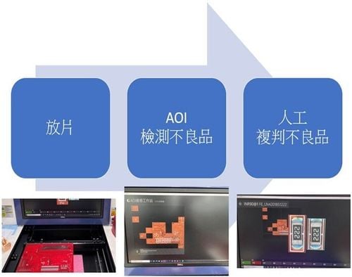
AOI inspection is one of the common stations in the passive component process, limited sample images are used in the current stage to compare the appearance. However, when switching between product batches, there are often problems with light source parameter adjustment, and the condition of these adjustments will affect the over-screening (mis-screening) of good products in each batch. In each batch of defective products in the industry, on average over-screening (mis-screening) occurs 20% of the time.

Relying on the guidance capabilities of the Southern Taiwan Industry Promotion Center, which has been deeply involved in Southern Taiwan for more than a decade, the company was matched with the AI image recognition technology unit of the Industrial Technology Research Institute (ITRI) to address the pain points of the passive component industry, reducing over-screening in the AOI process and also reduce errors caused by manual adjustment.

Using image recognition technology to reduce the occurrence of AOI over-screening

The technical unit of the ITRI that participated this time used image recognition technology to develop AOI technology for passive component processes in the establishment of AI modules.

In the development process, the company in this case first provided product appearance images and corresponding adjustment parameters, and then used the adjustment logic of current production line personnel to construct a product data set and further establish an AI model. When planning the production line test, the first priority is image recognition rate. Image detection and tag search are combined with comparison by an AI module to output AOI adjustment parameters for reference by online personnel.

Image analysis diagram

▲Image analysis diagram

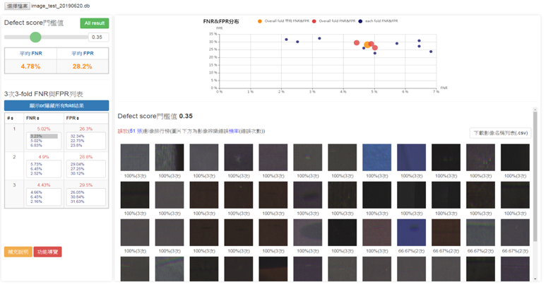
In the future, we also hope to use the help of machine learning to complete the AI learning curve for machine parameter adjustment, further reduce the over-screening rate of product appearance defect detection, simultaneously solve the gap in on-site professional and technical talent, and increase product yield.

Before and after scenario of incorporating machine learning

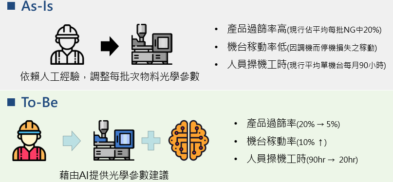
▲ Scenarios before and after implementing machine learning

Implementing AI applications in processes to lay the foundation for developing unmanned factories

In the future, we hope the guidance of AI HUB will accelerate the application of advanced process technology and establish AI indicators for each station of the passive component process, which will help domestic production of high quality passive component products and increase product yields and prices. It will use innovative thinking to increase the added value of the industry and continue to lead the passive component industry forward.

Recommend Cases

【導入案例】赫銳特科技VCSEL封裝元件瑕疵導入AOI檢測 提升產能效率20
HRT Technology Improves Production Efficiency by 20% Through AOI Detection of Defects in VCSEL Packaging

In 2017, the launch of the iPhone X made 3D sensor technology used in Face ID highly popular, which drove the development of VCSEL, a core component in the 3D sensor module In the detection of defects in incoming packaged VCSEL, the use of AI inference models can solve the industry's issue with low yield and improve reliability to 95 VCSEL technology currently can be used in many applications and various end consumer markets, including robots, mobile devices, surveillance, drones, and ARVR VCSELs are a good solution in applications that require high-speed modulation capabilities, such as cameras and biometrics VCSEL technology has a wide range ofnbsp applications, including in drones Pictured Zoyi Technology's Agricultural Drone VCSEL technology has a wide range of applications, AI technology assists in defect detection HRT Technology stated that the packaged VCSEL market is also facing strong price competition from competitors, and needs to further reduce costs and enhance product competitiveness One of the key problems is the replacement of glass lens with epoxy resin lens The production of traditional glass lenses has high yield, but the cost is higher than that of epoxy resin lenses Due to the cutting process of epoxy resin, the side wall of cutting lines can easily have rough edges, causing it to be oversized The release of stress caused by heat during the mounting process will directly cause the optical lens to break HRT Technology pointed out that the incoming inspection of VCSEL epoxy resin lenses is very important Under the constraints of packaging space, the space for fitting the package and optical lens is limited Moreover, the optical lenses will be confined to a metal frame If the dimensional tolerances are properly controlled, stress release due to heat during mounting can easily cause the optical lens to break, resulting in a yield loss of up to 10 in the VCSEL package reliability verification, resulting in an increase in production costs In order to solve the problems above, HRT Technology hopes to use AI to monitor the size and appearance defects of epoxy resin components in the VCSEL epoxy resin lens incoming stage, verifying whether their dimensions meet specifications, whether the cutting edges are smooth, and whether there are any defects in their appearance Since traditional incoming material inspection requires a rough visual inspection by humans to distinguish the quality The problem of image collection needs to be solved first to successfully collect image data Therefore, HRT Technology first developed an Automated Optical Inspection AOI device, which includes X, Y, Z three-axis motion, high-resolution cameras, and related control software to automatically record images After collecting the image data, opencv aligns the test image and a normal image to determine differences between the two images, and then pixel mapping is used to compare the pixel area to complete initial screening Manual labeling is carried out according to the image classification above, including samples that are normal, have defects in appearance, or have different shape characteristics, and then algorithm training and verification is carried out Residual neural network ResNet or other related algorithms are used for deep learning to identify the quality of lenses Implementation of AOI inspection improves production efficiency by 20 and above Comparing the differences before and after the implementation of AI image inspection, the incoming VCSEL lens inspection before implementation only involved manual inspection of the appearance The lens is packaged on the VCSEL package that has completed die bonding After passing the general light up test, the final reliability test high temperature reflow is performed Failed samples go into the rework process However, after the implementation of AOI inspection, it can screen defective lenses sooner and reduce the cost of subsequent materials input, it can also reduce the need for rework due to failure, improving yield to 95 and above in the reliability verification This is expected to help companies reduce production costs by 10 and increase production efficiency by 20 and above The difference before and after implementing AI image detection HRT Technology pointed out that this technology is an AI application developed based on tiny images It uses deep learning algorithms to identify defects in the images The trained network automatically classifies image data to predetermined categories Defect categories can be determined through reference images, so cumbersome programming is not required In the industrial machine vision environment, deep learning is mainly used for classification tasks in applications, such as inspection of industrial products or identification of parts In the future, with the development of IoT wearable devices and the trend of energy saving, the size of optoelectronic components will continue to shrink This technology can be applied to the detection of defects in the appearance of other tiny optoelectronic components in the future

【導入案例】化身大型AIOT科技遊樂場 海科館華麗轉身好吸睛
Transforming into a Large-Scale AIoT Technology Playground: The Spectacular Makeover of the National Museum of Marine Science & Technology

Taiwan is a maritime nation When you visit the Badozi Fishing Port or Tidal Park in Keelung, do you also explore the mysteries of the ocean world at the 48-hectare National Museum of Marine Science amp Technology To get more people closer to marine technology, Keelung's Marine Museum has introduced technological services, transforming the venue into a large technology playground that delights both children and adults, fully utilizing the 'learning through play' approach After a lengthy planning process, Northern Taiwan's largest marine science museum in Keelung opened in January 2014 The museum focuses on marine education and technology, boasting Taiwan's largest IMAX 3D ocean theater The unique themes and modern viewing facilities should make it a well-known landmark in Keelung However, the original exhibition planning was static and highly specialized, lacking sufficient interaction with the public Visitors who have attended the museum also reported that the exhibits were limited and quite boring, leading to poor overall consumer experience ratings The top three dissatisfactions with the museum were weak connections to surrounding attractions, unengaging display content, and lack of exhibit material According to statistics from the Marine Museum, the ratio of local to visiting guests is approximately 64, with most foreign visitors coming from the north transportation is primarily by car and bus common types of visits include family, parent-child, and friends and the stay duration is generally 1 to 2 hours Upon deeper investigation, the top three visitor complaints were weak linkages to surrounding attractions, unengaging display content, and insufficient number of exhibits The museum analyzed potential reasons, including some displays being too specialized, making it difficult for the public to understand, and a lack of interactive elements, making the exhibition boring and the visit hurriedly brief Analysis of visitor profiles revealed that since half of the museum's visitors are locals, and accessing the museum is not so easy for out-of-towners who must travel by car or public transport, the design of the venue and exhibitions must incorporate more interactivity and intrigue to encourage locals to return and extend the duration of visitors' stays while using technological services to highlight the museum's unique features Through a recommendation from the Information Software Association, part of the Ministry of Economic Affairs' Industrial Bureau AI team, the Marine Museum commissioned Jugu Technology to resolve the issue of uninspiring venue attractions Preliminary interviews by Jugu Technology revealed that many visitors were attracted by the architectural design of the museum, notices posted on nearby walls, flags, or events being held the most interesting feature for visitors was the 3D ocean theater, indicating that content presented through audio-video and physical scenic methods was more engaging Seven major AI technologies lead to a boost in regional tourism at the Marine Museum Through the introduction of technology services, Jugu Technology designed the 48-hectare site with seven major services AI voice tours, treasure hunt puzzle games, AI exhibit interactive revitalization, AI space exhibition interactive experience, AI crowd control, Face AI interactive experience, and AI voice customer service system By utilizing AIoT and cloud technology, they made the exhibition more interesting, not only solving the issue of boring static viewings for children but also doubling the learning efficiency and dramatically improving public perception of the Marine Museum, thus increasing visitor intent and boosting regional tourism The National Museum of Marine Science and Technology introduced seven major technological application services including AI voice guide Jugu Technology aimed to improve the space optimization of the Marine Museum, using the special exhibition of coastal birds in northern Taiwan as a prototype, integrating 'face', 'limb', 'crowd' as three main axes to enhance functionality and assist in improving the museum's application of AI Practically, the Marine Museum and Jugu Technology selected the on-site special exhibits to avoid any installation of water and electricity works or pipelines in active exhibits, thereby maintaining the quality of the viewing experience Instead, they selected exhibits that were not yet open to introduce a series of technological services tailored to the unique characteristics of the exhibits In the coastal bird special exhibition inside the Marine Museum, initial construction discussions with the curators utilized Bella X1 for a welcoming interactive introduction at the exhibition entrance This was followed by an AI-powered smart guide in both Chinese and English using X1 for narration, coupled with a fun treasure hunting stamp-collecting activity - APP X1, allowing visitors to participate in challenges Subsequently, bird species within the bird exhibition were brought to life interactively using X1, and AR scenarios X1 were introduced into the exhibition space to add elements of fun and entertainment Finally, Face AI was used to interactively test facial expressions and score smiles The gorgeously transformed Marine Museum will become the best travel destination for families with children ImageMarine Museum FB Page The AIoT services introduced by the Marine Museum could be extended to various exhibition-type museums and even static art galleries in the future, tailored to the unique characteristics of different venues They could also be promoted through government projects and related plans, aiding in rural revitalization, making visits more than just sightseeing in rural areas, and breaking free from stereotypes associated with different venues The applications of these services are broad「Translated content is generated by ChatGPT and is for reference only Translation date:2024-05-19」

【導入案例】巨量遙測空間數據AI分析雲端服務平台 使衛星遙測影像順利落地應用
AI Analysis Cloud Service Platform for Remote Sensing Big Data Enables the Smooth Application of Satellite Remote Sensing Images

Although satellite remote sensing images can make all surface objects visible, it still requires a lot of time and manpower to be truly applied to the industry In order to effectively solve the problems that customers face in digesting huge amounts of image data and eliminate technical obstacles for cross-domain users to process satellite remote sensing images, ThinkTron has developed an "AI Analysis Cloud Service Platform for Remote Sensing Big Data" as a new beginning for cross-domain AI applications for spatial information In recent years, in response to the impact of industrial globalization, Taiwan's agriculture has continued to transition towards technology-based and higher quality, improving the yield and quality of crops by solving problems, such as microclimate impacts and pest and disease control The demand of agriculture on images has expanded endlessly to accurately grasp the growing environment of crops In the early years when UAVs unmanned aerial vehicles were not yet popular, manual field surveys were the most basic but most labor-intensive work With the emergence of UAV drones, aerial photography operations might not be difficult, but the range that can be photographed is limited Furthermore, surveying expertise is required to accurately capture spatial information At this time, the use of satellite remote sensing data may break away from the past imagination of using image data Taiwan Space Agency TASA ODC data warehouse services In the past ten years, with the breakthrough of modern satellite remote sensing application technology, Digital Earth has become a new trend in global data collection Countries have developed data cube image storage technology, and the development of smart agriculture has become one of the largest image users Determining planting distribution is the first step in understanding crop yields Free satellite remote sensing images, powerful data warehousing support, and the team's robust image recognition technology are important supports for accelerating agricultural transformation Using satellite remote sensing image data can accelerate the development of smart agriculture However, in the past, it was difficult to extract large-area crop distribution through satellite remote sensing images, not to mention the cost If you wanted to use free information, you had to visit all websites of international space agencies, look through the wide variety of satellite specifications, and carefully evaluate the sensor specifications, image resolution, and revisit cycle After finding suitable images, you had to look at them one by one to filter the ones you need Next is downloading dozens of images that are often several hundreds of Megabytes MB each, which might exceed the capacity of your computer Also, after overcoming image access and preparing data, you must then start to confirm the downloaded image products and which bands you want, because the image you see is not just an image file jpg or png, but rather complex multi-spectral information, attribute fields and coordinate information It takes a lot of effort just to confirm the correct information Facing GIS software packages with complex functions is the start of another trouble The complex image pre-processing process and the inflexible machine learning package greatly reduce the efficiency of analyzing data After finally getting the results of crop identification, you might find that the best time for using map information may have already passed The above-mentioned complex and time-consuming satellite image processing problems are precisely the pain points of the market ThinkTron expanded from traditional machine learning to modern deep learning applications, and developed an "AI Analysis Cloud Service Platform for Remote Sensing Big Data" under the GeoAI framework, breaking through the constraints of details in the spatial information for customers Differences between the process before and after introducing the AI analysis cloud service platform ThinkTron said that Taiwan's ODC Open Data Cube system has been completed and began providing services after years of efforts from the Taiwan Space Agency TASA, formally becoming aligned with international trends The powerful warehousing technology allows users to easily capture and use image data of a specific time and spatial range according to their needs The warehouse stores multiple satellite image resources from international space agencies, including the ESA's Sentinel-1 one image every 6 days, Sentinel-2 one image every 6 days, USGS's Landsat-7 one image every 16 days, Landsat-8 one image every 16 days, and the domestic Formosat-2 one image every day and Formosat-5 one image every 2 days ThinkTron develops satellite image recognition tools based on Python Breaking free from the limitations of GIS Geographic Information System software packages, ThinkTron integrated GDAL Geospatial Data Abstraction Library based on Python, and considered computing efficiency and parallel processing when developing all tools required for satellite image processing and image recognition modeling, including coordinate system and data format conversion, grid and vector data interaction, and data intra-difference and normalization All of the tools are designed with AI applications in mind, and some commonly used tools are packaged into an open source package under the name TronGisPy to benefit the technical community ThinkTron utilized the team's understanding of satellite remote sensing images and the collected tagged data crop distribution maps to preset the image recognition modeling process, the required training data specifications, and dataset definitions This is imported into the machine learning LightGBM or deep learning CNN framework that was completed in advance, and the entire training process to be performed in the Web GIS interface, providing users with partial flexibility to freely filter images, confirm spatial and temporal ranges, select models, and adjust hyperparameters In addition to the operation of training models, it also provides historical models to output identification results, and finally displays the identification results of crop distribution on the Web GIS map In fact, agriculture is not the only industry that needs satellite remote sensing applications AI applications of spatial information have also appeared in various fields as companies in different industries aim to enhance their global competitiveness For example, surveying and mapping companies that have a large amount of map data can use the AI analysis cloud service platform to store map data while also accelerating the efficiency of digital mapping Under the severe global climate change and the risk of strong earthquakes, there is a wide variety industrial insurance, agricultural insurance, financial insurance, or disaster insurance are all inseparable from spatial information The use of remote sensing image recognition to understand insurance targets has long been an international trend AI Analysis Cloud Service Architecture for Remote Sensing Big Data