:::

【2020 Application Example】 AI Smart Customer Service Maintenance Response System, solving customer machinery fault issues instantly through chatting!

A tool machine manufacturer that markets successfully both domestically and internationally, but also faces challenges?

A domestic tool machine manufacturer specializing in CNC wire cut machines, CNC EDM machines, and CNC fine hole EDM machines, uses its strong core capability in electromechanical development to deliver high-precision, high-quality products. It has successfully developed an aviation engine turbine ring wire cutting machine and specializes in designing and manufacturing super-large custom models, successfully marketing its products to over 30 countries worldwide.

Though capable of marketing high-quality products, the lack of standardized processes and methodologies for machine maintenance means that it often requires significant manpower and time to address machine failures, increasing maintenance costs...

No fast repair solutions, difficult personnel training, high maintenance time costs

While the tool machine manufacturer can sell high-precision machinery globally, encountering maintenance situations always consumes a lot of manpower and money. This is due to the lack of standardized troubleshooting processes for machine maintenance, mainly relying on the experience of maintenance technicians and the machine error codes. Not all faults can be diagnosed through codes. Technicians can only initially judge based on the error codes, then hypothesize the likely fault causes for further inspection and maintenance. There is also no standard way to record the repair methods, making it difficult to quickly troubleshoot similar issues in the future.

In addition to 'lack of standardized fault troubleshooting process', there are also issues of 'difficult personnel training' and 'high maintenance time costs'. Technicians need years of repair experience and must be familiar with mechanics, electronics, and mechanical engineering. If error codes are not available during repair, it requires considerable time to identify the problem with the machine, causing significant time and cost losses.

▲Traditional way of addressing issues through email

Implementing the 'AI Smart Customer Service Maintenance Response System' reduces costs for maintenance visits, shortens the duration of repairs, and simultaneously enhances the product's value.

Considering the pain points mentioned, the needs of the tool machine manufacturer are threefold: firstly, establishing a 'fault troubleshooting AI image recognition maintenance knowledge base system'. Then, collecting data on machine failures to establish a 'machine fault condition database'. Lastly, integrating AI image recognition and deep learning functions to analyze photos taken at the time of the machine's failure in order to identify the most closely related fault issues and troubleshooting methods.

This 'AI Smart Customer Service Maintenance Response System' predominantly uses 'supervised learning' as its primary AI technique. The 'AI model' part involves 'CNN' (Convolutional Neural Networks), which is used for image recognition and obtaining extensive training data on machine malfunctions and recommended maintenance methods for effective AI predictions. The 'data analysis' part uses 'DNN' (Deep Neural Networks) to acquire reference data related to fault conditions after training, providing answers that maintenance staff and clients desire for repairs, reducing the rate of maintenance visits and enhancing the product's added value. Additionally, 'AlexNet' is used as a preliminary development tool; its parameters can be set independently and executed automatically, ensuring that the AI model trained aligns closely with expected outcomes.

Currently, the tool machine manufacturer has around 10,000 graphic and text entries, predominantly 'image data'. The system uses images for fault identification and text to assist in the diagnosis of abnormalities. It employs '360-degree panoramic modeling' to archive graphic data and stores numerous image files internally. Additionally, it gathers relevant data such as electrical currents, voltages, water pressures, and flow rates via sensors, utilizing them for associated decision-making processes. The following pictorial representation shows the system service process:

AI Smart Response Customer Service System Service Process Chart

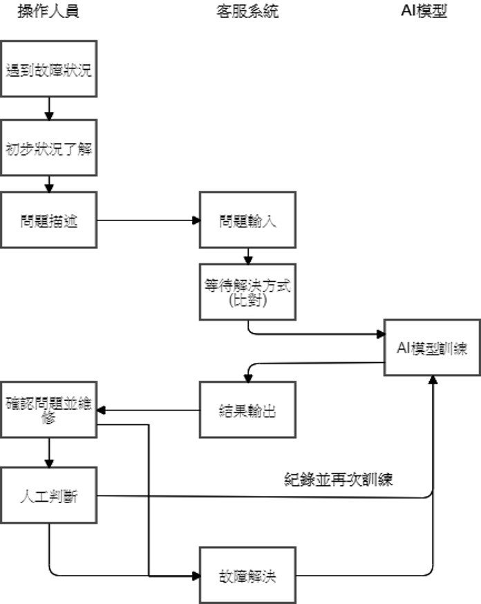
▲AI Smart Response Customer Service System Service Process Chart

This system gathers experiences from technical maintenance staff and information on machine faults to establish databases containing: machine fault conditions, machine fault images, maintenance actions, and completions of machines. It logs the comprehensive repair records, and leveraging AI image recognition and data analysis, it determines the most likely fault conditions. Through accumulated maintenance experience, the machine is enabled to autonomously learn and decide, offering the most suitable solutions to technicians or clients, thus shortening the training and repair time for technicians, reducing clients' downtime and costs, and increasing the machine's additional product value.

Promoting the 'AI Smart Customer Service Maintenance Response System' across various industries for greater economic impact!

This 'AI Smart Customer Service Maintenance Response System' initially sets up a maintenance knowledge base, then employs Chatbot technology to integrate smart customer service, allowing clients to interact directly via chat to quickly resolve basic machine faults. In the training of maintenance technicians, AI can also swiftly classify and inform of the likely fault causes and troubleshooting steps, thus lessening training and repair duration. By effectively solving issues like the lack of quick repair solutions, difficulty in training personnel, and high maintenance time costs, it is poised to expand its applications to other industries for more significant economic outcomes in the future.

AI Intelligent Reply Customer Service System - Smart Image Recognition Customer Service Illustration

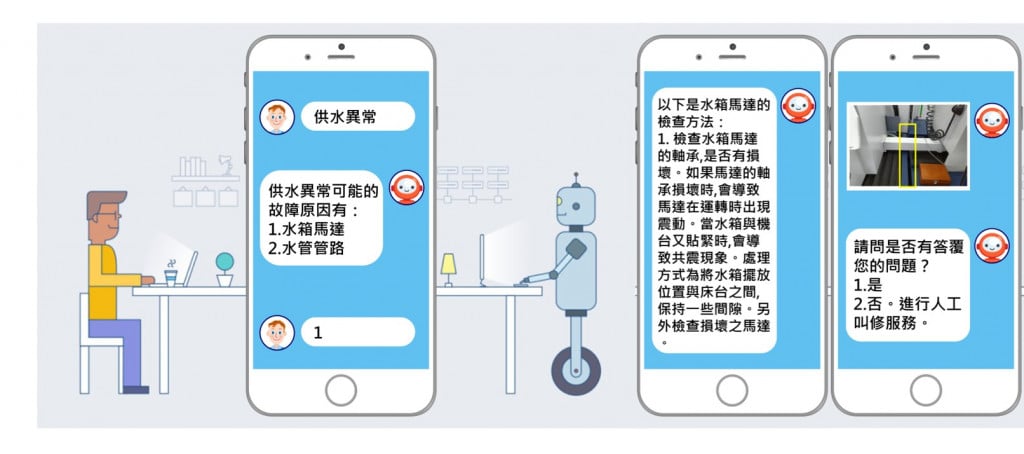
▲AI Intelligent Reply Customer Service System - Smart Image Recognition Customer Service Illustration

「Translated content is generated by ChatGPT and is for reference only. Translation date:2024-05-19」

Recommend Cases

【解決方案】佐翼科技無人機導入高爾夫球場域 可節省一半人力
Droxo Tech Applies Drones in Golf Courses to Reduce Manpower by Half

For most golf courses, the operations and management is a headache "Golf courses are selling turf and need to be properly taken care of," a golf course manager bluntly pointed out Facing the market pain points of labor shortage, aging population and high cost, the use of AI drones for pesticide spraying and pest control will reduce labor costs by more than half and greatly improve the overall operational efficiency At noon in early summer, an AI drone is slowly taking off at the Taipei Golf Club in Taoyuan Its main task is to test AI drone fertilizing and pesticide spraying on the golf course In fact, drones of Droxo Tech, the company performing this task, are widely used for fertilization, pesticide spraying, and pest and disease control for rice, bananas, and tea trees For golf courses with turfs that often cover tens to hundreds of hectares, AI drones are needed to assist in turf maintenance Data collection, development of pesticide spraying AI models, and multispectral image analysis and testing will be carried out in the current stage In the future, large-scale technology implementation and verification will be carried out to set an example for applying drones to golf courses Using AI drones to fertilize and spray pesticides can reduce the manpower required by half The traditional way of maintaining the turf in golf courses is to carry spray buckets or drive spraying vehicles to spray areas one by one "Domestic golf courses began to plant ultra-dwarf Bermuda grass in 2001 This grass species prefers a cool climate and is not suitable for Taiwan's hot and humid weather" Droxo Techrsquos CEO further pointed out that to prevent turf from pests and diseases, pesticide spraying is necessary For an 18-hole golf course, it is equivalent to spraying pesticides once a week, and the T-ground and fairways are sprayed every two months For golf courses, spraying pesticides is time-consuming and labor-intensive It is important to note that large-scale spraying will increase the risk of personnel poisoning and increase the amount of pesticide used Benefits of applying agricultural drones to golf courses According to Droxo Techrsquos research, golf course pests include Spodoptera litura, which comes out at night to look for food, so pesticide spraying must be carried out in the evening According to the traditional method, pesticide spraying requires two vehicles and three personnel for a total of 45 hours If AI drones are used for fertilizing and pesticide spraying, it only takes one operator to spray 08 hectares of land in 20 minutes, saving about two-thirds of the manpower and reducing operating costs by about 30 Using AI drones to fertilize and spray pesticides on golf courses can reduce the manpower required by half In addition to the significant benefits of using agricultural drones for golf course turf maintenance, Droxo Tech also specially introduced AI multispectral image recognition for NDVI Normalized Difference Vegetation Index analysis "The so-called multispectral is to direct light with different wavelengths on the turf, and the reflected images are collected for analysis" Droxo Tech CEO Liu continued to explain that each plant absorbs light with different wavelengths, so multispectral imaging can determine the growth status of grass species At the same time, combined with AI image recognition, the distribution of pests and diseases can be accurately detected, and the amount of pesticide used is determined on this basis Cross-domain collaboration to build a multi-source turf image databasenbsp Using AI multispectral image recognition technology, Droxo Tech will collect visible light, multispectral, thermal images, and hyperspectral images to establish a multi-source turf image database to fully understand the growth cycle of Bermuda grass Droxo Tech has accumulated rich experience in agricultural AI drone pesticide spraying , but there are still many problems that need to be overcome to implement AI solutions in golf courses For example, it is necessary to establish a new pesticide spraying model and test flight methods, especially the application of multispectral image recognition PoC is not difficult, but actual implementation requires more test evidence, repeated inferences, and collaboration with plant experts This part must rely on the cross-domain integration of legal entities such as the Institute for Information Technology III, gathering more fields for verification, and creating a paradigm before it can be more widely adopted by golf courses There are not many international cases on the application of AI drones in golf courses During the verification process, it is not yet known whether it can be quickly copied to the next golf course However, Droxo Tech CEO Liu believes that through cross-domain collaboration, clearly defining the problems and listing them one by one, supply and demand parties can reach a consensus, propose solutions to each problem, and seek cooperation with internal and external resources Only then will we be able to gradually achieve the goal of making golf courses smarter and smoothly assist the industry with transformation Zuoyi Technology's CEO, Liu Junlin 「Translated content is generated by ChatGPT and is for reference only Translation date:2024-05-19」

這是一張圖片。 This is a picture.
AI Assists the Red Cross for Smarter Emergency Response

More Preparation Less Loss The Taiwan Food Bank Association, a non-profit organization, collects donations daily from wholesalers, retailers, manufacturers, and even kind-hearted individuals across Taiwan They also rescue consumable materials that are about to be discarded, properly allocate and deliver to households in need, aiding local underprivileged populations When natural disasters such as earthquakes, landslides, mudslides, typhoons, floods, and droughts occur in Taiwan, the food bank's resources can be immediately deployed for disaster relief This field verification unit is the Nantou County Red Cross AssociationOne of the food bank locations, hereinafter referred to as the Nantou Red CrossIs responsible for tasks like pre-disaster supplies preparation and disaster relief material distribution, helping the government bear the responsibility of disaster relief and aid In Taiwan, various natural disasters have characteristics of different duration and spatial coverage, wide or narrow With the normalization of extreme weather, the scale and number of disasters are gradually increasing and becoming harder to predict The required amount and type of materials differ by disaster, and they must address the lifestyles of the affected areas, rescue needs, traffic conditions, geographical restrictions, and other factors for varied material allocation, facing numerous challenges Typhoon Kanu severely damaged transportation in Nantou mountain areas Nantou County Red Cross planned the mountainous route Puli gt Fazhi Elementary School gt Qin'ai Village gt Aowanda to deliver supplies Disasters happen repeatedly We need to be prepared at all times Effective disaster preparedness can mitigate the impact, including swift response to material needs in affected areas, aid distribution, and even psychological support, providing added security for life and property of those in disaster zones Lack of Timeliness in Disaster Information To improve the living conditions and address the lack of supplies in remote areas, the Taiwan Food Bank Association has partnered with the Nantou Red Cross and has successively established food bank points in Nantou City, Puli, and Ren'aiLixing, Ruiyan, XinyiWangmei, Tongfu, Shuili, Lugu and Caotun among others9establish food bank locations, providing supplies worth a certain amount per household every month6001000in New Taiwan Dollars However, many challenges still need to be overcome during natural disasters For example, when typhoons, earthquakes, and landslides occur, the information source for disaster relief dispatch systems relies on post-disaster reports The time lag between reporting, response, and execution prevents timely adjustment and distribution of 'disaster relief' supplies based on the needs of affected areas, affecting rescue efficiency due to lack of timely information The 'preparedness' supplies of the Nantou Red Crosssuch as dry food, water, instant noodles, etc,are recorded manually in terms of stock, expiration dates, and distribution,When a disaster occurs, there is a chance that 'preparedness' supplies have expired and cannot become 'disaster relief' supplies It’s also possible that both conditions mentioned above occur simultaneously, leading to a need for more time to reassign 'preparedness' supplies into usable 'disaster relief' materials On the other hand, upon receiving information about shortages in disaster areas, the supplies donated by the public often grossly differ from the actual needs of the disaster zone, leading to an excess of supplies The Process of Material Operations Before and After a Natural Disaster AIAnticipating Natural Disasters Reinforcing the Accuracy of Preparedness Material Dispatch Application API Technology connects to compute the state of the climate, the intensity of disaster rescues, prioritizing the main tasks of the Nantou Red Cross and the needed areas of search and rescue Coordinated with the existing heavy rain and typhoon simulation disaster training of the Nantou Red Cross, a 'Natural Disaster Emergency Preparedness Material Dispatch and Supplement Decision System' is establishedreferred to as the Emergency Preparedness Material System。 In material management, inventory data along with immediate supply data are entered into the Emergency Preparedness Material System for comparison and analysis, helping the Nantou Red Cross quickly recognize materials like cookiesdry food, beverages, frozen food, toilet paper, etc, and determining whether they should be 'preparedness' materials or regularly distributed materials Adding to this, information forecasting understands the potential disaster conditions in remote areas, facilitating food delivery, addressing both front-end food wastage and backend practical needs When a natural disaster occurs, it enables faster response and decision-making, completing material deployment, hence increasing the speed of material operation transition20。 AI Emergency Preparedness Material System Helps Rapidly Adapt Material Distribution Through the field verification of the Nantou Red CrossAIthe system, material management, and related applications are promoted to more emergency response organizations in different areas, while continuously improving the alert functions within the Emergency Preparedness Material System, strengthening the technological foundation for alerts, enhancing prediction accuracySystem immediacy, and optimizing the data collection and analysis process Simultaneously, it can collaborate with government agencies, meteorological departments, or other rescue teams to discuss integrating more data sources, establishing a mechanism to share resources and data promptly, sharing information in real-time, helping more emergency response organizations enhance their disaster response abilities, seizing the golden rescue time 「Translated content is generated by ChatGPT and is for reference only Translation date:2024-12-12」

【導入案例】巨量遙測空間數據AI分析雲端服務平台 使衛星遙測影像順利落地應用
AI Analysis Cloud Service Platform for Remote Sensing Big Data Enables the Smooth Application of Satellite Remote Sensing Images

Although satellite remote sensing images can make all surface objects visible, it still requires a lot of time and manpower to be truly applied to the industry In order to effectively solve the problems that customers face in digesting huge amounts of image data and eliminate technical obstacles for cross-domain users to process satellite remote sensing images, ThinkTron has developed an "AI Analysis Cloud Service Platform for Remote Sensing Big Data" as a new beginning for cross-domain AI applications for spatial information In recent years, in response to the impact of industrial globalization, Taiwan's agriculture has continued to transition towards technology-based and higher quality, improving the yield and quality of crops by solving problems, such as microclimate impacts and pest and disease control The demand of agriculture on images has expanded endlessly to accurately grasp the growing environment of crops In the early years when UAVs unmanned aerial vehicles were not yet popular, manual field surveys were the most basic but most labor-intensive work With the emergence of UAV drones, aerial photography operations might not be difficult, but the range that can be photographed is limited Furthermore, surveying expertise is required to accurately capture spatial information At this time, the use of satellite remote sensing data may break away from the past imagination of using image data Taiwan Space Agency TASA ODC data warehouse services In the past ten years, with the breakthrough of modern satellite remote sensing application technology, Digital Earth has become a new trend in global data collection Countries have developed data cube image storage technology, and the development of smart agriculture has become one of the largest image users Determining planting distribution is the first step in understanding crop yields Free satellite remote sensing images, powerful data warehousing support, and the team's robust image recognition technology are important supports for accelerating agricultural transformation Using satellite remote sensing image data can accelerate the development of smart agriculture However, in the past, it was difficult to extract large-area crop distribution through satellite remote sensing images, not to mention the cost If you wanted to use free information, you had to visit all websites of international space agencies, look through the wide variety of satellite specifications, and carefully evaluate the sensor specifications, image resolution, and revisit cycle After finding suitable images, you had to look at them one by one to filter the ones you need Next is downloading dozens of images that are often several hundreds of Megabytes MB each, which might exceed the capacity of your computer Also, after overcoming image access and preparing data, you must then start to confirm the downloaded image products and which bands you want, because the image you see is not just an image file jpg or png, but rather complex multi-spectral information, attribute fields and coordinate information It takes a lot of effort just to confirm the correct information Facing GIS software packages with complex functions is the start of another trouble The complex image pre-processing process and the inflexible machine learning package greatly reduce the efficiency of analyzing data After finally getting the results of crop identification, you might find that the best time for using map information may have already passed The above-mentioned complex and time-consuming satellite image processing problems are precisely the pain points of the market ThinkTron expanded from traditional machine learning to modern deep learning applications, and developed an "AI Analysis Cloud Service Platform for Remote Sensing Big Data" under the GeoAI framework, breaking through the constraints of details in the spatial information for customers Differences between the process before and after introducing the AI analysis cloud service platform ThinkTron said that Taiwan's ODC Open Data Cube system has been completed and began providing services after years of efforts from the Taiwan Space Agency TASA, formally becoming aligned with international trends The powerful warehousing technology allows users to easily capture and use image data of a specific time and spatial range according to their needs The warehouse stores multiple satellite image resources from international space agencies, including the ESA's Sentinel-1 one image every 6 days, Sentinel-2 one image every 6 days, USGS's Landsat-7 one image every 16 days, Landsat-8 one image every 16 days, and the domestic Formosat-2 one image every day and Formosat-5 one image every 2 days ThinkTron develops satellite image recognition tools based on Python Breaking free from the limitations of GIS Geographic Information System software packages, ThinkTron integrated GDAL Geospatial Data Abstraction Library based on Python, and considered computing efficiency and parallel processing when developing all tools required for satellite image processing and image recognition modeling, including coordinate system and data format conversion, grid and vector data interaction, and data intra-difference and normalization All of the tools are designed with AI applications in mind, and some commonly used tools are packaged into an open source package under the name TronGisPy to benefit the technical community ThinkTron utilized the team's understanding of satellite remote sensing images and the collected tagged data crop distribution maps to preset the image recognition modeling process, the required training data specifications, and dataset definitions This is imported into the machine learning LightGBM or deep learning CNN framework that was completed in advance, and the entire training process to be performed in the Web GIS interface, providing users with partial flexibility to freely filter images, confirm spatial and temporal ranges, select models, and adjust hyperparameters In addition to the operation of training models, it also provides historical models to output identification results, and finally displays the identification results of crop distribution on the Web GIS map In fact, agriculture is not the only industry that needs satellite remote sensing applications AI applications of spatial information have also appeared in various fields as companies in different industries aim to enhance their global competitiveness For example, surveying and mapping companies that have a large amount of map data can use the AI analysis cloud service platform to store map data while also accelerating the efficiency of digital mapping Under the severe global climate change and the risk of strong earthquakes, there is a wide variety industrial insurance, agricultural insurance, financial insurance, or disaster insurance are all inseparable from spatial information The use of remote sensing image recognition to understand insurance targets has long been an international trend AI Analysis Cloud Service Architecture for Remote Sensing Big Data