:::

【2020 Application Example】 AI Implementation in Construction Industry Reduces Workplace Accidents: Safety Visibility Enhanced

The construction industry is Taiwan's leading industry, supporting the architecture, decoration, and repair sectors. However, the high incidence of occupational accidents in this sector is a major concern for both employers and workers. The introduction of AI for equipment recognition in the construction industry reassures companies and protects workers, creating a win-win situation.

According to the Ministry of Labor's 2017 statistics on occupational injuries, the average rate of occupational injuries per thousand workers across various industries is 2.773. However, the construction industry tops the list with a rate of 10.036, which is 3.6 times the average and categorizes it as a high-risk group for occupational injuries. Proactive early warning measures can significantly reduce the rate of workplace accidents.

In light of this, the Institute for Information Industry, under the mandate of the Ministry of Economic Affairs' Industrial Development Bureau, has initiated an AI project that prioritizes the implementation of AI technology in the construction industry. Selecting well-known construction firms in Taiwan, the project applies Canon's safety helmet proper wearing recognition solution to reduce occupational accident rates.

Smart Recognition of Safety Helmet Wearing: A Solution for Employers

Senior executives in the construction industry emphasize that compared to other industries, construction workers face higher health and safety risks primarily at construction sites. Many risks arise from the workers not properly wearing or using personal protective equipment, such as safety helmets. Relying solely on human supervision for ensuring safety gear compliance is time-consuming and often ineffective. Implementing AI technology for smart monitoring on construction sites can save corporate resources while ensuring worker safety, achieving dual benefits.

Indeed, to protect workers during operations, construction plants require workers to properly wear safety helmets. Wearing a helmet does not imply it is worn correctly. To prevent the helmet from falling off during operations, it is necessary to securely fasten the chin strap directly under the chin after putting on the helmet.
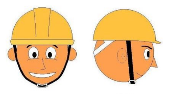
Proper Wearing Method for Construction Site Safety Helmets

▲工地用安全帽正確佩戴方法

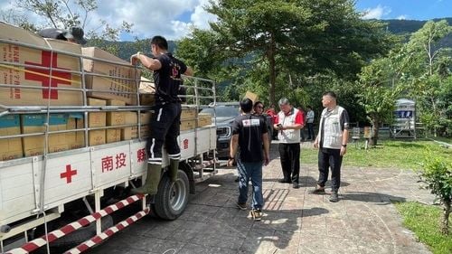
At construction sites, many foreign workers often do not follow proper safety protocols, such as not wearing safety helmets correctly. If supervisory personnel were to be assigned, it would entail excessive use of human resources. With the assistance of the information strategy team, major construction companies have adopted Canon's image recognition technology.

To determine the optimal placement of image recognition cameras, both teams first conduct site surveys and collect various types of safety helmets used on-site. Subsequently, standard cameras are installed at entry points of construction sites and work zones to capture footage of the site personnel. This footage helps Canon develop models for correctly and incorrectly worn helmets, aiding the image recognition software in its learning phase. Canon's engineers regularly visit the site to retrieve footage, and once the image recognition software achieves a certain accuracy level, the image recognition cameras are then installed at the construction site.

Canon Construction Site Safety Helmet Data Collection Camera Setup

▲佳能工地安全帽資料搜集攝影機設置

Improving Recognition Accuracy for Concrete Implementation of Workplace Safety

Currently, no local technology can accurately recognize the proper wearing of safety helmets. Therefore, Canon has developed and trained its own recognition software. The complex environment at the actual installation sites can impact the effectiveness of recognition.

In the future, machine learning will significantly enhance the overall recognition accuracy, ensuring that safety measures involving the wearing of safety helmets are concretely implemented.

While AI recognition technology is introduced in the construction industry's safety domain, it can also be integrated with mobile devices for early warning. In practice, once a camera captures recognition data and processes it, the results can be pushed immediately to specific individuals such as safety managers on their mobile phones, tablets, or even linked to access control systems. If a worker is detected without a properly worn safety helmet, relevant personnel can be alerted promptly. Access can be denied until the worker correctly wears the safety helmet, offering considerable potential for future applications.

「Translated content is generated by ChatGPT and is for reference only. Translation date:2024-05-19」

Recommend Cases

【導入案例】巨量遙測空間數據AI分析雲端服務平台 使衛星遙測影像順利落地應用
AI Analysis Cloud Service Platform for Remote Sensing Big Data Enables the Smooth Application of Satellite Remote Sensing Images

Although satellite remote sensing images can make all surface objects visible, it still requires a lot of time and manpower to be truly applied to the industry In order to effectively solve the problems that customers face in digesting huge amounts of image data and eliminate technical obstacles for cross-domain users to process satellite remote sensing images, ThinkTron has developed an "AI Analysis Cloud Service Platform for Remote Sensing Big Data" as a new beginning for cross-domain AI applications for spatial information In recent years, in response to the impact of industrial globalization, Taiwan's agriculture has continued to transition towards technology-based and higher quality, improving the yield and quality of crops by solving problems, such as microclimate impacts and pest and disease control The demand of agriculture on images has expanded endlessly to accurately grasp the growing environment of crops In the early years when UAVs unmanned aerial vehicles were not yet popular, manual field surveys were the most basic but most labor-intensive work With the emergence of UAV drones, aerial photography operations might not be difficult, but the range that can be photographed is limited Furthermore, surveying expertise is required to accurately capture spatial information At this time, the use of satellite remote sensing data may break away from the past imagination of using image data Taiwan Space Agency TASA ODC data warehouse services In the past ten years, with the breakthrough of modern satellite remote sensing application technology, Digital Earth has become a new trend in global data collection Countries have developed data cube image storage technology, and the development of smart agriculture has become one of the largest image users Determining planting distribution is the first step in understanding crop yields Free satellite remote sensing images, powerful data warehousing support, and the team's robust image recognition technology are important supports for accelerating agricultural transformation Using satellite remote sensing image data can accelerate the development of smart agriculture However, in the past, it was difficult to extract large-area crop distribution through satellite remote sensing images, not to mention the cost If you wanted to use free information, you had to visit all websites of international space agencies, look through the wide variety of satellite specifications, and carefully evaluate the sensor specifications, image resolution, and revisit cycle After finding suitable images, you had to look at them one by one to filter the ones you need Next is downloading dozens of images that are often several hundreds of Megabytes MB each, which might exceed the capacity of your computer Also, after overcoming image access and preparing data, you must then start to confirm the downloaded image products and which bands you want, because the image you see is not just an image file jpg or png, but rather complex multi-spectral information, attribute fields and coordinate information It takes a lot of effort just to confirm the correct information Facing GIS software packages with complex functions is the start of another trouble The complex image pre-processing process and the inflexible machine learning package greatly reduce the efficiency of analyzing data After finally getting the results of crop identification, you might find that the best time for using map information may have already passed The above-mentioned complex and time-consuming satellite image processing problems are precisely the pain points of the market ThinkTron expanded from traditional machine learning to modern deep learning applications, and developed an "AI Analysis Cloud Service Platform for Remote Sensing Big Data" under the GeoAI framework, breaking through the constraints of details in the spatial information for customers Differences between the process before and after introducing the AI analysis cloud service platform ThinkTron said that Taiwan's ODC Open Data Cube system has been completed and began providing services after years of efforts from the Taiwan Space Agency TASA, formally becoming aligned with international trends The powerful warehousing technology allows users to easily capture and use image data of a specific time and spatial range according to their needs The warehouse stores multiple satellite image resources from international space agencies, including the ESA's Sentinel-1 one image every 6 days, Sentinel-2 one image every 6 days, USGS's Landsat-7 one image every 16 days, Landsat-8 one image every 16 days, and the domestic Formosat-2 one image every day and Formosat-5 one image every 2 days ThinkTron develops satellite image recognition tools based on Python Breaking free from the limitations of GIS Geographic Information System software packages, ThinkTron integrated GDAL Geospatial Data Abstraction Library based on Python, and considered computing efficiency and parallel processing when developing all tools required for satellite image processing and image recognition modeling, including coordinate system and data format conversion, grid and vector data interaction, and data intra-difference and normalization All of the tools are designed with AI applications in mind, and some commonly used tools are packaged into an open source package under the name TronGisPy to benefit the technical community ThinkTron utilized the team's understanding of satellite remote sensing images and the collected tagged data crop distribution maps to preset the image recognition modeling process, the required training data specifications, and dataset definitions This is imported into the machine learning LightGBM or deep learning CNN framework that was completed in advance, and the entire training process to be performed in the Web GIS interface, providing users with partial flexibility to freely filter images, confirm spatial and temporal ranges, select models, and adjust hyperparameters In addition to the operation of training models, it also provides historical models to output identification results, and finally displays the identification results of crop distribution on the Web GIS map In fact, agriculture is not the only industry that needs satellite remote sensing applications AI applications of spatial information have also appeared in various fields as companies in different industries aim to enhance their global competitiveness For example, surveying and mapping companies that have a large amount of map data can use the AI analysis cloud service platform to store map data while also accelerating the efficiency of digital mapping Under the severe global climate change and the risk of strong earthquakes, there is a wide variety industrial insurance, agricultural insurance, financial insurance, or disaster insurance are all inseparable from spatial information The use of remote sensing image recognition to understand insurance targets has long been an international trend AI Analysis Cloud Service Architecture for Remote Sensing Big Data

這是一張圖片。 This is a picture.
AI-Based PCBA Surface Defect Detection Improvements

With the introduction of theAOIAIWith the introduction of the system, we can improve product yield, reduce costs, and from a business perspective, increase customer trust and sales revenue Moreover, AIit has advantages that are difficult to imitate, unlike other equipment that can be bought with money, making it hard for our competitors to catch up with us Our company's current development We are committed toIOTsmart manufacturing our systems already include smart materials systems, environmental humidity control systems, anti-miscarriage systems, smart procurement computation systems, smart inventory systems, solder paste management systems, and production management systems We have asked other manufacturers about the possibility ofAIinspectingPCBAsurface defects, each hoping that we would purchase their equipment, but none were effective upon verification After discussing with IT service providers, we defined it asAOIAIa feasible operational model Tzuhong Technology has invested inAOIAIan inspection plan to checkSMTtext on components, solder joints, polarity, missing partsand usingAIto replace manual learningAOIand define the 'potentially defective' parts, enhancing productivity and reducing misjudgment rates Industry pain points Taiwan faces a severe labor shortage, especially those willing to perform visual inspections are few and typically older, increasing the frequency of missed inspections Thus, the most critical bottleneck in the pursuit of high-quality electronics has become post-production inspections Previous consumer products with undetected anomalies were acceptable within a certain ratio However, in the automotive industry today, undetected defects could lead to fatalities hence, the automotive industry has extremely high quality demands To survive in the automotive supply chain, we must address the issue of undetectable anomalies Moreover, as wages in Taiwan continue to rise, we can only endeavor toAIreplace traditional manpower with technology, otherwise, even if the anomaly leakage problem is resolved, the relatively high labor costs will still prevent competitiveness in this industry Application technology and explanation Initially,Figure 1,PCBUpon emerging,Reflowsystem, it will undergoAOIwill undergo inspection, dividing into 'suspected defective' and good products At this point, the 'suspected defective' portion accounts for20manual review for these20parts, further classifying the 'suspected defective' portion into good and defective products With We aim to leverageAItechnology, to shift from manual re-inspection of these20technology, we aim to replace manual review of 'suspected defective' products withAIand after review, the results still yield 'good' and 'suspected defective' products, but now 'suspected defective' comprises only3thus reducing the workload of Tzuhong's employees from20down to only3In theory, it isAOIIn theory, after inspection, it is further reviewed byAIbut it appears to go throughAOIonly, so we call this technologyA0IAIDetectionFigure 2。 The original AOI inspection process The operator will place the testPCBboard intoAOIthe inspection equipment, outputtingAOI information on defective products, then manually re-inspect one by one to determine if they are defective AOIAI inspection process The operator will place the testPCBboard intoAOIthe inspection equipment, outputtingAOIinformation on defective products after, then proceed byAIfirst performingAOIre-assessment of defective products, outputtingAIinformation on defective products afterward, then manually re-inspect one by one to determine if they are defective Process differences By introducing theAOIAIsystem, not only can we enhance the efficiency and yield of visual inspection personnel, we also have this timeAIexperience in system introduction, we will also incorporateAIthe use of big data into Tzuhong's existing smart manufacturing systems, further enhancing the performance of our smart manufacturing systems and reducing the pressure on employees Difference between pre and post-introduction Promotion strategy 1 Similar field diffusion allSMTmanufacturers face bottlenecks in inspections leading to shipment delays introducing this system can solve the severe labor shortage issue and enhance shipment speed and quality, allowing self-promotion to customers or through equipment dealers to cater to relevant needs 2 Cross-industry expansion plans negotiate withAOImanufacturers to directly integrateAIthe system intoAOItheir systems, enhancing their market competitiveness Profit strategy 1 In collaboration withAOImanufacturers, collect licensing fees 2 Direct sales toSMTthe manufacturing industryAIsystems 3 ProvideSMTmanufacturing industryAOIAIsystem subscription model「Translated content is generated by ChatGPT and is for reference only Translation date:2024-12-09」

【解決方案】連聯合國都買單 悠由數據應用運用農業數據搶攻全球商機
Even the United Nations is on board! Yoyo Data Application captures global business opportunities with agricultural data

Nearly 2,000 days in the fields have made Yoyo Data Application a top player in Taiwan’s agricultural data sector Their comprehensive grasp of crop yields, production periods, and prices has enabled them to collaborate with the United Nations The service area for agricultural land skyrocketed from 24 hectares to over 6,000 hectares in less than three years—a 250-fold increase For Wu Junxiao, founder and CEO of Yoyo Data Application, aligning with global environmental trends and becoming a data company at the intersection of climate technology and the green economy to serve the global market is his ultimate entrepreneurial goal Wu Junxiao, originally an engineer, joined the Industrial Technology Research Institute in 2010, where he honed his profound technical and data science analytic skills 'At that time, I was working in data analysis engineering, and almost all data-related materials would be directed to me Additionally, I worked on indoor cultivation boxes, planting vegetables and mushrooms, hence planting the seed of entrepreneurship by integrating agriculture with data analysis,' Wu recalls Since 2016, Wu Junxiao has been frequently visiting farms to 'embed' himself among farmers and agricultural researchers, chatting and sharing information systematically, which quickly established his agricultural know-how Solid data analysis capabilities have even convinced the United Nations In 2017, he left the Institute to start his own business and founded Yoyo Data Application in 2019 Today, many agricultural businesses are his clients, with service areas rapidly climbing from 24 hectares to over 6,000 hectares, expected to surpass 7,000 hectares in 2022 His clientele includes markets in Japan, Central America, and even entities under the United Nations like the World Farmers Organization, which utilizes the 'Yoyo Crop Algorithm System' supported by Yoyo Data How exactly does Yoyo Data Application manage to impress even UN agencies The 'Yoyo Crop Algorithm System' developed by Yoyo Data Application accurately predicts the production period, yield, and prices Firstly, due to Wu Junxiao's precise mastery over agricultural data, Yoyo Data Application's clients don't necessarily need sensors or other hardware devices 'Sensors are expensive and if you buy cheap devices, you just collect a lot of noise or flawed data, which is useless,' Wu explains He continues, 'Collecting data doesn't necessarily require sensors our data solutions can solve problems more directly and effectively' For instance, one of Yoyo Data Application's products, the Yoyo Money Report Agri-price Linebot, developed in collaboration with LINE in 2020, gathers data on origin, wholesale, and terminal prices spanning over 10 years, driven by Yoyo Data’s proprietary AI algorithms This enables the system to autonomously learn about agricultural product trading prices, using big data and AI to perform price prediction analysis, thereby helping buyers reduce transaction risks and expanding the data application to the entire agricultural supply chain Regarding banana prices, the accuracy of price predictions increased from the original 70 to 998 Wu Junxiao notes that both buyers and farmers are very sensitive to prices Now, through the Yoyo Money Report service, both buyers and farmers can precisely understand the fluctuations in agricultural product prices Yoyo Data can also provide customers with optimal decision-making advice based on predictive models for crop growth, yield, and price estimations Currently, price predictions cover 28 types of crops Precise estimates of production periods and price fluctuations allow Yoyo Data to provide differentiated services based on data analysis The 'Yoyo Crop Algorithm System' provided by Yoyo Data Application incorporates a 'Parameter Bank', usually collecting 200-300 parameters, not just straightforward data like temperature and humidity, but also data divided according to the physiological characteristics of the crops Through effective dynamic data algorithms, it can accurately calculate when crops will flower and when they can be harvested, what the yield will be, and so forth For instance, the prediction accuracy of the broccoli production period is 0-4 days, with the flowering period predicted this year to be precisely 0 days, perfectly matching the actual flowering time in the field In these dynamic calculations, a 7-day range is considered reasonable, and the average error value of Yoyo Data's predictions typically ranges from 2-4 days, with most crop production period accuracies above 80 Through effective dynamic data algorithms, over 120 global crops can have their production periods and yields accurately estimated Using these effective dynamic data algorithms can set estimates for production quantities, helping adjust at the production end Yoyo Data Application's clientele primarily includes exporters of fruit crops like pineapples, bananas, guavas, mangos, pomelos, sugar apples, Taiwan's agricultural production is highly homogenized, often leading to a rush to plant the same crops and resulting in price crashes Yoyo Data Application helps clients differentiate their offerings Thus, Wu Junxiao positions his company as a boutique digital consultant, carefully selecting clients for quality over quantity He notes that Taiwanese agricultural clients focus on how to improve yield rates, even categorizing yield rates by quality, aiming for high-quality, specialized export markets whereas international clients prioritize maximizing per-unit yields, showing different operational approaches in domestic and international markets In addition to agricultural fruit, Yoyo Data Application has also extended its services to the fisheries sector, including species like milkfish, sea bass, and white shrimp, all using the same system to establish various parameters related to the growth of fish and shrimp, such as when to feed and when to harvest, and the anticipated yield, timing, and prices Yoyo Data Application harnesses the power of data to create miracles in smart agriculture In response to the company's rapid development, Yoyo Data Application introduced venture capital funds in 2021 to expand its staff and promote its business Wu Junxiao states that in response to the global trend towards net zero carbon emissions by 2050, he plans to help clients plant carbon in the soil, effectively retaining carbon in the land while also connecting clients to carbon trading platforms, creating environmental business opportunities together Wu Junxiao says that from the start of his entrepreneurial journey, he positioned the company as a global entity, thus continuous international collaborations are planned As a data company serving a global clientele and focused on climate technology and the green economy, this represents Wu’s expectations for himself and his company's long-term goals Yoyo Data Application founder and CEO Wu Junxiao「Translated content is generated by ChatGPT and is for reference only Translation date:2024-05-19」