:::

【2020 Application Example】 AI Bread Recognition System, machine scans, and the price is instantly calculated for you!

A brilliant idea transforming AI facial recognition technology

As artificial intelligence develops, more and more industries are embracing AI technology, even subtly entering into people's lives. As most bakeries sell freshly made bread and pastries, which typically do not have barcodes, they rely on cashiers to visually identify each item and enter the type and price of the bread. Thus, inspired by AI facial recognition technology, if such artificial intelligence could identify hundreds of types of bread, it could enhance checkout efficiency...

Diverse handmade breads delight customers but challenge clerks!

A local bakery has over 100 types of bread, regularly updating or adding new products, offering customers a variety of choices; this poses a challenge for cashiers.

It takes two months to train a cashier, but even after they start, there's still a 5 to 10% error rate due to bread recognition mistakes each month, especially during peak checkout times after work, causing bottlenecks and further errors due to the stress on cashiers. The difficulty in training cashiers and the lack of precision in the checkout process have long troubled businesses...

When baking meets artificial intelligence, it sparks a marvelous retail experience!

In typical bakeries, bread is sold 'naked' immediately after baking and then 'packaged' when it cools to room temperature. Both methods require cashiers to recognize and remember the prices and undergo two months of training before they can work the cash register. Even then, there is still a 5 to 10% error rate each month. My Dee Bakery, with its extensive range of over 100 bread types, poses a significant challenge for cashiers!

Due to Yun Kui Technology Co., Ltd.'s expertise in developing iPad POS systems, which are designed to be simple, convenient, and easy to use, they allow businesses to check out efficiently and accurately. Therefore, integrating the existing POS system with AI image recognition capabilities enables businesses to carry out transactions more efficiently and precisely.

AI bread recognition model operational schematic (Image provided by Yun Kui Technology)

▲AI bread recognition model operational schematic (Image provided by Yun Kui Technology)

The execution can be simplified into eight steps, which include:

1. Data collection: Take bread image data at bakeries.

2. Image annotation: The image data is handed over to Mu Kesi Co., Ltd. for manual annotation.

3. AI modeling and training: Managed by Mu Kesi, who adjusts AI models and training.

4. iPad POS adjustment: Simultaneous adjustments of the UI interface on the POS side and backend integration with the AI model.

5. Start testing: Once Mu Kesi reaches over 95% recognition accuracy with current data, formal integration testing begins.

6. Real scene testing: Move to the bakery to gather data and verify the correct recognition rates.

7. Planning real scene application accessories: When recognition accuracy exceeds 98%, design accessories for on-site checkout, such as remote cameras and projection light sources.

8. Official Application: Integration with electronic receipts goes live.

POS machine AI bread recognition checkout process: Start recognition - Recognition complete - Checkout - Confirm checkout, takes only 3 seconds (Image provided by Yun Kui Technology)

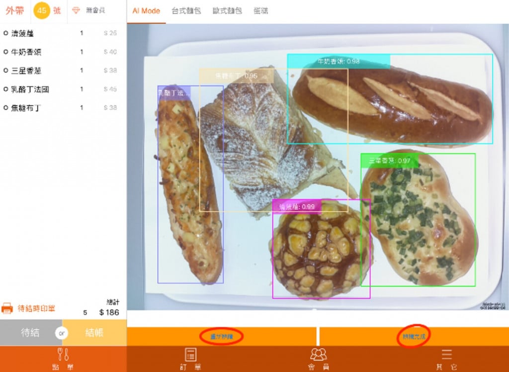
▲POS machine AI bread recognition checkout process: Start recognition - Recognition complete - Checkout - Confirm checkout, takes only 3 seconds (Image provided by Yun Kui Technology)

AI bread recognition system, making multitasking easy!

After adding AI capabilities, not only can it save upfront training time and costs for bakery cashiers and reduce costs from recognition errors, but it can also speed up the checkout process and efficiency, increasing customer satisfaction. This can later be promoted to various retail industries, expanding the new map of smart retail.

Comparison chart of bread checkout process before and after AI valuation (Image provided by Yun Kui Technology)

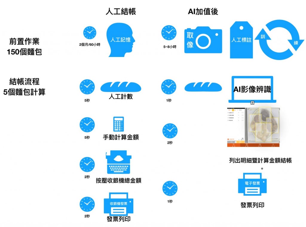
▲Before and after comparison chart of the bread checkout process with AI valuation (Image provided by Yun Kui Technology)

「Translated content is generated by ChatGPT and is for reference only. Translation date:2024-05-19」

Recommend Cases

【導入案例】化身大型AIOT科技遊樂場 海科館華麗轉身好吸睛
Transforming into a Large-Scale AIoT Technology Playground: The Spectacular Makeover of the National Museum of Marine Science & Technology

Taiwan is a maritime nation When you visit the Badozi Fishing Port or Tidal Park in Keelung, do you also explore the mysteries of the ocean world at the 48-hectare National Museum of Marine Science amp Technology To get more people closer to marine technology, Keelung's Marine Museum has introduced technological services, transforming the venue into a large technology playground that delights both children and adults, fully utilizing the 'learning through play' approach After a lengthy planning process, Northern Taiwan's largest marine science museum in Keelung opened in January 2014 The museum focuses on marine education and technology, boasting Taiwan's largest IMAX 3D ocean theater The unique themes and modern viewing facilities should make it a well-known landmark in Keelung However, the original exhibition planning was static and highly specialized, lacking sufficient interaction with the public Visitors who have attended the museum also reported that the exhibits were limited and quite boring, leading to poor overall consumer experience ratings The top three dissatisfactions with the museum were weak connections to surrounding attractions, unengaging display content, and lack of exhibit material According to statistics from the Marine Museum, the ratio of local to visiting guests is approximately 64, with most foreign visitors coming from the north transportation is primarily by car and bus common types of visits include family, parent-child, and friends and the stay duration is generally 1 to 2 hours Upon deeper investigation, the top three visitor complaints were weak linkages to surrounding attractions, unengaging display content, and insufficient number of exhibits The museum analyzed potential reasons, including some displays being too specialized, making it difficult for the public to understand, and a lack of interactive elements, making the exhibition boring and the visit hurriedly brief Analysis of visitor profiles revealed that since half of the museum's visitors are locals, and accessing the museum is not so easy for out-of-towners who must travel by car or public transport, the design of the venue and exhibitions must incorporate more interactivity and intrigue to encourage locals to return and extend the duration of visitors' stays while using technological services to highlight the museum's unique features Through a recommendation from the Information Software Association, part of the Ministry of Economic Affairs' Industrial Bureau AI team, the Marine Museum commissioned Jugu Technology to resolve the issue of uninspiring venue attractions Preliminary interviews by Jugu Technology revealed that many visitors were attracted by the architectural design of the museum, notices posted on nearby walls, flags, or events being held the most interesting feature for visitors was the 3D ocean theater, indicating that content presented through audio-video and physical scenic methods was more engaging Seven major AI technologies lead to a boost in regional tourism at the Marine Museum Through the introduction of technology services, Jugu Technology designed the 48-hectare site with seven major services AI voice tours, treasure hunt puzzle games, AI exhibit interactive revitalization, AI space exhibition interactive experience, AI crowd control, Face AI interactive experience, and AI voice customer service system By utilizing AIoT and cloud technology, they made the exhibition more interesting, not only solving the issue of boring static viewings for children but also doubling the learning efficiency and dramatically improving public perception of the Marine Museum, thus increasing visitor intent and boosting regional tourism The National Museum of Marine Science and Technology introduced seven major technological application services including AI voice guide Jugu Technology aimed to improve the space optimization of the Marine Museum, using the special exhibition of coastal birds in northern Taiwan as a prototype, integrating 'face', 'limb', 'crowd' as three main axes to enhance functionality and assist in improving the museum's application of AI Practically, the Marine Museum and Jugu Technology selected the on-site special exhibits to avoid any installation of water and electricity works or pipelines in active exhibits, thereby maintaining the quality of the viewing experience Instead, they selected exhibits that were not yet open to introduce a series of technological services tailored to the unique characteristics of the exhibits In the coastal bird special exhibition inside the Marine Museum, initial construction discussions with the curators utilized Bella X1 for a welcoming interactive introduction at the exhibition entrance This was followed by an AI-powered smart guide in both Chinese and English using X1 for narration, coupled with a fun treasure hunting stamp-collecting activity - APP X1, allowing visitors to participate in challenges Subsequently, bird species within the bird exhibition were brought to life interactively using X1, and AR scenarios X1 were introduced into the exhibition space to add elements of fun and entertainment Finally, Face AI was used to interactively test facial expressions and score smiles The gorgeously transformed Marine Museum will become the best travel destination for families with children ImageMarine Museum FB Page The AIoT services introduced by the Marine Museum could be extended to various exhibition-type museums and even static art galleries in the future, tailored to the unique characteristics of different venues They could also be promoted through government projects and related plans, aiding in rural revitalization, making visits more than just sightseeing in rural areas, and breaking free from stereotypes associated with different venues The applications of these services are broad「Translated content is generated by ChatGPT and is for reference only Translation date:2024-05-19」

【解決方案】佐翼科技無人機導入高爾夫球場域 可節省一半人力
Droxo Tech Applies Drones in Golf Courses to Reduce Manpower by Half

For most golf courses, the operations and management is a headache "Golf courses are selling turf and need to be properly taken care of," a golf course manager bluntly pointed out Facing the market pain points of labor shortage, aging population and high cost, the use of AI drones for pesticide spraying and pest control will reduce labor costs by more than half and greatly improve the overall operational efficiency At noon in early summer, an AI drone is slowly taking off at the Taipei Golf Club in Taoyuan Its main task is to test AI drone fertilizing and pesticide spraying on the golf course In fact, drones of Droxo Tech, the company performing this task, are widely used for fertilization, pesticide spraying, and pest and disease control for rice, bananas, and tea trees For golf courses with turfs that often cover tens to hundreds of hectares, AI drones are needed to assist in turf maintenance Data collection, development of pesticide spraying AI models, and multispectral image analysis and testing will be carried out in the current stage In the future, large-scale technology implementation and verification will be carried out to set an example for applying drones to golf courses Using AI drones to fertilize and spray pesticides can reduce the manpower required by half The traditional way of maintaining the turf in golf courses is to carry spray buckets or drive spraying vehicles to spray areas one by one "Domestic golf courses began to plant ultra-dwarf Bermuda grass in 2001 This grass species prefers a cool climate and is not suitable for Taiwan's hot and humid weather" Droxo Techrsquos CEO further pointed out that to prevent turf from pests and diseases, pesticide spraying is necessary For an 18-hole golf course, it is equivalent to spraying pesticides once a week, and the T-ground and fairways are sprayed every two months For golf courses, spraying pesticides is time-consuming and labor-intensive It is important to note that large-scale spraying will increase the risk of personnel poisoning and increase the amount of pesticide used Benefits of applying agricultural drones to golf courses According to Droxo Techrsquos research, golf course pests include Spodoptera litura, which comes out at night to look for food, so pesticide spraying must be carried out in the evening According to the traditional method, pesticide spraying requires two vehicles and three personnel for a total of 45 hours If AI drones are used for fertilizing and pesticide spraying, it only takes one operator to spray 08 hectares of land in 20 minutes, saving about two-thirds of the manpower and reducing operating costs by about 30 Using AI drones to fertilize and spray pesticides on golf courses can reduce the manpower required by half In addition to the significant benefits of using agricultural drones for golf course turf maintenance, Droxo Tech also specially introduced AI multispectral image recognition for NDVI Normalized Difference Vegetation Index analysis "The so-called multispectral is to direct light with different wavelengths on the turf, and the reflected images are collected for analysis" Droxo Tech CEO Liu continued to explain that each plant absorbs light with different wavelengths, so multispectral imaging can determine the growth status of grass species At the same time, combined with AI image recognition, the distribution of pests and diseases can be accurately detected, and the amount of pesticide used is determined on this basis Cross-domain collaboration to build a multi-source turf image databasenbsp Using AI multispectral image recognition technology, Droxo Tech will collect visible light, multispectral, thermal images, and hyperspectral images to establish a multi-source turf image database to fully understand the growth cycle of Bermuda grass Droxo Tech has accumulated rich experience in agricultural AI drone pesticide spraying , but there are still many problems that need to be overcome to implement AI solutions in golf courses For example, it is necessary to establish a new pesticide spraying model and test flight methods, especially the application of multispectral image recognition PoC is not difficult, but actual implementation requires more test evidence, repeated inferences, and collaboration with plant experts This part must rely on the cross-domain integration of legal entities such as the Institute for Information Technology III, gathering more fields for verification, and creating a paradigm before it can be more widely adopted by golf courses There are not many international cases on the application of AI drones in golf courses During the verification process, it is not yet known whether it can be quickly copied to the next golf course However, Droxo Tech CEO Liu believes that through cross-domain collaboration, clearly defining the problems and listing them one by one, supply and demand parties can reach a consensus, propose solutions to each problem, and seek cooperation with internal and external resources Only then will we be able to gradually achieve the goal of making golf courses smarter and smoothly assist the industry with transformation Zuoyi Technology's CEO, Liu Junlin 「Translated content is generated by ChatGPT and is for reference only Translation date:2024-05-19」

【導入案例】巨量遙測空間數據AI分析雲端服務平台 使衛星遙測影像順利落地應用
AI Analysis Cloud Service Platform for Remote Sensing Big Data Enables the Smooth Application of Satellite Remote Sensing Images

Although satellite remote sensing images can make all surface objects visible, it still requires a lot of time and manpower to be truly applied to the industry In order to effectively solve the problems that customers face in digesting huge amounts of image data and eliminate technical obstacles for cross-domain users to process satellite remote sensing images, ThinkTron has developed an "AI Analysis Cloud Service Platform for Remote Sensing Big Data" as a new beginning for cross-domain AI applications for spatial information In recent years, in response to the impact of industrial globalization, Taiwan's agriculture has continued to transition towards technology-based and higher quality, improving the yield and quality of crops by solving problems, such as microclimate impacts and pest and disease control The demand of agriculture on images has expanded endlessly to accurately grasp the growing environment of crops In the early years when UAVs unmanned aerial vehicles were not yet popular, manual field surveys were the most basic but most labor-intensive work With the emergence of UAV drones, aerial photography operations might not be difficult, but the range that can be photographed is limited Furthermore, surveying expertise is required to accurately capture spatial information At this time, the use of satellite remote sensing data may break away from the past imagination of using image data Taiwan Space Agency TASA ODC data warehouse services In the past ten years, with the breakthrough of modern satellite remote sensing application technology, Digital Earth has become a new trend in global data collection Countries have developed data cube image storage technology, and the development of smart agriculture has become one of the largest image users Determining planting distribution is the first step in understanding crop yields Free satellite remote sensing images, powerful data warehousing support, and the team's robust image recognition technology are important supports for accelerating agricultural transformation Using satellite remote sensing image data can accelerate the development of smart agriculture However, in the past, it was difficult to extract large-area crop distribution through satellite remote sensing images, not to mention the cost If you wanted to use free information, you had to visit all websites of international space agencies, look through the wide variety of satellite specifications, and carefully evaluate the sensor specifications, image resolution, and revisit cycle After finding suitable images, you had to look at them one by one to filter the ones you need Next is downloading dozens of images that are often several hundreds of Megabytes MB each, which might exceed the capacity of your computer Also, after overcoming image access and preparing data, you must then start to confirm the downloaded image products and which bands you want, because the image you see is not just an image file jpg or png, but rather complex multi-spectral information, attribute fields and coordinate information It takes a lot of effort just to confirm the correct information Facing GIS software packages with complex functions is the start of another trouble The complex image pre-processing process and the inflexible machine learning package greatly reduce the efficiency of analyzing data After finally getting the results of crop identification, you might find that the best time for using map information may have already passed The above-mentioned complex and time-consuming satellite image processing problems are precisely the pain points of the market ThinkTron expanded from traditional machine learning to modern deep learning applications, and developed an "AI Analysis Cloud Service Platform for Remote Sensing Big Data" under the GeoAI framework, breaking through the constraints of details in the spatial information for customers Differences between the process before and after introducing the AI analysis cloud service platform ThinkTron said that Taiwan's ODC Open Data Cube system has been completed and began providing services after years of efforts from the Taiwan Space Agency TASA, formally becoming aligned with international trends The powerful warehousing technology allows users to easily capture and use image data of a specific time and spatial range according to their needs The warehouse stores multiple satellite image resources from international space agencies, including the ESA's Sentinel-1 one image every 6 days, Sentinel-2 one image every 6 days, USGS's Landsat-7 one image every 16 days, Landsat-8 one image every 16 days, and the domestic Formosat-2 one image every day and Formosat-5 one image every 2 days ThinkTron develops satellite image recognition tools based on Python Breaking free from the limitations of GIS Geographic Information System software packages, ThinkTron integrated GDAL Geospatial Data Abstraction Library based on Python, and considered computing efficiency and parallel processing when developing all tools required for satellite image processing and image recognition modeling, including coordinate system and data format conversion, grid and vector data interaction, and data intra-difference and normalization All of the tools are designed with AI applications in mind, and some commonly used tools are packaged into an open source package under the name TronGisPy to benefit the technical community ThinkTron utilized the team's understanding of satellite remote sensing images and the collected tagged data crop distribution maps to preset the image recognition modeling process, the required training data specifications, and dataset definitions This is imported into the machine learning LightGBM or deep learning CNN framework that was completed in advance, and the entire training process to be performed in the Web GIS interface, providing users with partial flexibility to freely filter images, confirm spatial and temporal ranges, select models, and adjust hyperparameters In addition to the operation of training models, it also provides historical models to output identification results, and finally displays the identification results of crop distribution on the Web GIS map In fact, agriculture is not the only industry that needs satellite remote sensing applications AI applications of spatial information have also appeared in various fields as companies in different industries aim to enhance their global competitiveness For example, surveying and mapping companies that have a large amount of map data can use the AI analysis cloud service platform to store map data while also accelerating the efficiency of digital mapping Under the severe global climate change and the risk of strong earthquakes, there is a wide variety industrial insurance, agricultural insurance, financial insurance, or disaster insurance are all inseparable from spatial information The use of remote sensing image recognition to understand insurance targets has long been an international trend AI Analysis Cloud Service Architecture for Remote Sensing Big Data