【2021 Application Example】 Transforming into a Large-Scale AIoT Technology Playground: The Spectacular Makeover of the National Museum of Marine Science & Technology
Taiwan is a maritime nation. When you visit the Badozi Fishing Port or Tidal Park in Keelung, do you also explore the mysteries of the ocean world at the 48-hectare National Museum of Marine Science & Technology? To get more people closer to marine technology, Keelung's Marine Museum has introduced technological services, transforming the venue into a large technology playground that delights both children and adults, fully utilizing the 'learning through play' approach.
After a lengthy planning process, Northern Taiwan's largest marine science museum in Keelung opened in January 2014. The museum focuses on marine education and technology, boasting Taiwan's largest IMAX 3D ocean theater. The unique themes and modern viewing facilities should make it a well-known landmark in Keelung. However, the original exhibition planning was static and highly specialized, lacking sufficient interaction with the public. Visitors who have attended the museum also reported that the exhibits were limited and quite boring, leading to poor overall consumer experience ratings.
The top three dissatisfactions with the museum were weak connections to surrounding attractions, unengaging display content, and lack of exhibit material
According to statistics from the Marine Museum, the ratio of local to visiting guests is approximately 6:4, with most foreign visitors coming from the north; transportation is primarily by car and bus; common types of visits include family, parent-child, and friends; and the stay duration is generally 1 to 2 hours.
Upon deeper investigation, the top three visitor complaints were weak linkages to surrounding attractions, unengaging display content, and insufficient number of exhibits. The museum analyzed potential reasons, including some displays being too specialized, making it difficult for the public to understand, and a lack of interactive elements, making the exhibition boring and the visit hurriedly brief. Analysis of visitor profiles revealed that since half of the museum's visitors are locals, and accessing the museum is not so easy for out-of-towners who must travel by car or public transport, the design of the venue and exhibitions must incorporate more interactivity and intrigue to encourage locals to return and extend the duration of visitors' stays while using technological services to highlight the museum's unique features.
Through a recommendation from the Information Software Association, part of the Ministry of Economic Affairs' Industrial Bureau AI team, the Marine Museum commissioned Jugu Technology to resolve the issue of uninspiring venue attractions. Preliminary interviews by Jugu Technology revealed that many visitors were attracted by the architectural design of the museum, notices posted on nearby walls, flags, or events being held; the most interesting feature for visitors was the 3D ocean theater, indicating that content presented through audio-video and physical (scenic) methods was more engaging.
Seven major AI technologies lead to a boost in regional tourism at the Marine Museum
Through the introduction of technology services, Jugu Technology designed the 48-hectare site with seven major services: AI voice tours, treasure hunt puzzle games, AI exhibit interactive revitalization, AI space exhibition interactive experience, AI crowd control, Face AI interactive experience, and AI voice customer service system. By utilizing AIoT and cloud technology, they made the exhibition more interesting, not only solving the issue of boring static viewings for children but also doubling the learning efficiency and dramatically improving public perception of the Marine Museum, thus increasing visitor intent and boosting regional tourism.
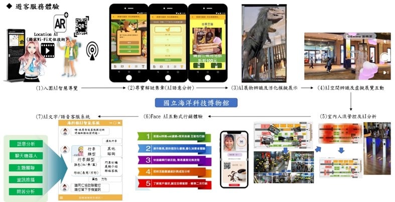
The National Museum of Marine Science and Technology introduced seven major technological application services including AI voice guide.
Jugu Technology aimed to improve the space optimization of the Marine Museum, using the special exhibition of coastal birds in northern Taiwan as a prototype, integrating 'face', 'limb', 'crowd' as three main axes to enhance functionality and assist in improving the museum's application of AI. Practically, the Marine Museum and Jugu Technology selected the on-site special exhibits to avoid any installation of water and electricity works or pipelines in active exhibits, thereby maintaining the quality of the viewing experience. Instead, they selected exhibits that were not yet open to introduce a series of technological services tailored to the unique characteristics of the exhibits.
In the coastal bird special exhibition inside the Marine Museum, initial construction discussions with the curators utilized Bella X1 for a welcoming interactive introduction at the exhibition entrance. This was followed by an AI-powered smart guide (in both Chinese and English using X1) for narration, coupled with a fun treasure hunting stamp-collecting activity - APP X1, allowing visitors to participate in challenges. Subsequently, bird species within the bird exhibition were brought to life interactively using X1, and AR scenarios X1 were introduced into the exhibition space to add elements of fun and entertainment. Finally, Face AI was used to interactively test facial expressions and score smiles.
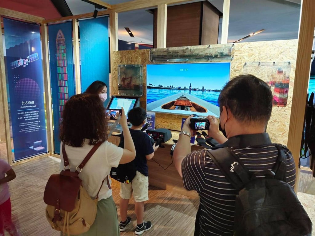
The gorgeously transformed Marine Museum will become the best travel destination for families with children. (Image/Marine Museum FB Page)
The AIoT services introduced by the Marine Museum could be extended to various exhibition-type museums and even static art galleries in the future, tailored to the unique characteristics of different venues. They could also be promoted through government projects and related plans, aiding in rural revitalization, making visits more than just sightseeing in rural areas, and breaking free from stereotypes associated with different venues. The applications of these services are broad.
「Translated content is generated by ChatGPT and is for reference only. Translation date:2024-05-19」