:::

【2020 Application Example】 AI Fights Pandemic: 6 Times Efficiency Increase in Wuhan Pneumonia Quarantine

Combatting the epidemic is like fighting a fire. With the increasing influx of returning residents, the pressure of Wuhan virus quarantine is mounting, consuming more time. Shortening quarantine times will positively benefit disease prevention efforts. At a hospital in Southern Taiwan, the 'Smart Medical Clinical Decision Support System' has helped reduce the time taken for high-risk patients from entry at the quarantine station to clinical decisions by doctors. It originally took about 2 and a half hours, but now it's down to less than 30 minutes, increasing the quarantine efficiency by 5 to 6 times and significantly reducing the risk of cross-infection between medical personnel and patients, as well as the manpower needed for quarantine.

As waves of overseas students densely return to Taiwan, not only the Central Epidemic Command Center, but also various medical institutions are tightening up, closely monitoring every quarantined individual. There are also concerns about the potential infection risks to colleagues, which is exhausting. At this point, employing AI technology to enhance quarantine efficiency is indeed a great blessing for the medical units and the health of the nation.

AI-Assisted Medicine Multiplies, Becoming a Hero in Pandemic Control

To combat the severe pandemic of novel coronavirus, the hospital has integrated various smart medical techs and developed the 'Smart Medical Clinical Decision Support System', raising quarantine efficiency by 5 to 6 times. It has shortened the time taken for high-risk patients from entering the quarantine station to doctors making clinical decisions from 2 and a half hours to less than 30 minutes, effectively reducing the risk of cross-infections.

The 'Smart Medical Clinical Decision Support System' implemented by the hospital includes three components: front-end automation of medical records, AI-assisted interpretation of chest X-rays for diagnosing pneumonia, and continuous updates of clinical decisions based on the latest epidemic data provided by the health department. This significantly enhances the hospital's response and decision-making ability in quarantine and epidemic prevention, and greatly benefits Taiwan's anti-epidemic efforts through the multiplicative effect of AI-assisted medicine.

National Cheng Kung University collaborates with the hospital, using smart medical technology to enhance quarantine efficiency (Photo source: Official website)

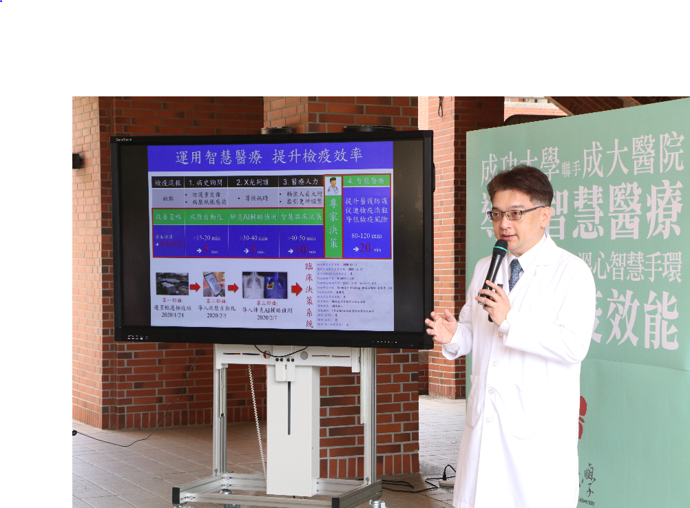
▲ National Cheng Kung University collaborates with the hospital, using smart medical technology to enhance quarantine efficiency (Photo source: Official website)

In the aspect of medical record automation, existing medical institutions often use traditional paper or verbal reporting, which potentially increases the risk of contact infections among medical staff and patients. The automated medical records system in this hospital allows patients to fill out their own medical history, including travel, occupation, contacts, and clustering, using tablet computers. These records are uploaded to the electronic medical record system, enabling immediate access by medical staff to make clinical decisions. Each tablet is disinfected with alcohol after every use, reducing the risk of cross-infection and enhancing the efficiency of the quarantine station.

The hospital's Wuhan pneumonia screening shows a sensitivity and accuracy of up to 80% and 90%, respectively.

The 'Chest X-Ray AI Interpretation for Pneumonia System Model' developed by the hospital's Department of Radiology, with active participation from Professor Yong-Nian Sun's team at the College of Electrical Engineering and Computer Science. Utilizing a tuberculosis X-ray AI auto-interpretation model developed by a previous AI biotech medical innovation research center project, it was adapted to the hospitals' pneumonia imaging data. The collaboration between the parties ensured rapid completion. Currently assisting in over 152 suspected Wuhan pneumonia screenings, sensitivities and accuracies of up to 80% and 90% have been achieved, respectively.

Moreover, for students conducting in-home quarantine at school dormitories, the university has adopted a smart monitoring approach with a 'Warm Heart Smart Bracelet' developed by a cross-disciplinary team, which continuously monitors quarantined individuals' body temperatures and heart rates as indicators for predicting symptoms. When a rise in body temperature is detected, individuals can proactively confirm abnormal symptoms via a smartphone app and be prompted to seek medical attention. Currently, bracelets are collected weekly and data is centrally uploaded to a cloud platform by the management staff for ongoing tracking, wholly enhancing the level of pandemic control internally and externally.

The cross-disciplinary team at the university uses 'Warm Heart Smart Bracelets' to implement home quarantine policies effectively (Photo source: Official website)

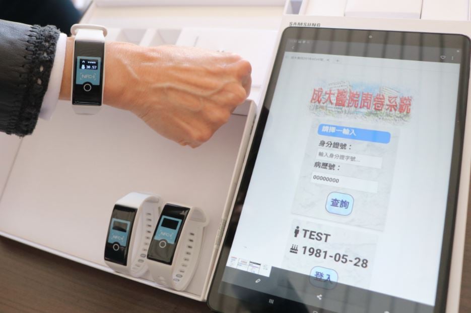
▲ The university's cross-disciplinary team uses 'Warm Heart Smart Bracelets' to implement home quarantine policies effectively (Photo source: Official website)

「Translated content is generated by ChatGPT and is for reference only. Translation date:2024-05-19」

Recommend Cases

【導入案例】巨量遙測空間數據AI分析雲端服務平台 使衛星遙測影像順利落地應用
AI Analysis Cloud Service Platform for Remote Sensing Big Data Enables the Smooth Application of Satellite Remote Sensing Images

Although satellite remote sensing images can make all surface objects visible, it still requires a lot of time and manpower to be truly applied to the industry In order to effectively solve the problems that customers face in digesting huge amounts of image data and eliminate technical obstacles for cross-domain users to process satellite remote sensing images, ThinkTron has developed an "AI Analysis Cloud Service Platform for Remote Sensing Big Data" as a new beginning for cross-domain AI applications for spatial information In recent years, in response to the impact of industrial globalization, Taiwan's agriculture has continued to transition towards technology-based and higher quality, improving the yield and quality of crops by solving problems, such as microclimate impacts and pest and disease control The demand of agriculture on images has expanded endlessly to accurately grasp the growing environment of crops In the early years when UAVs unmanned aerial vehicles were not yet popular, manual field surveys were the most basic but most labor-intensive work With the emergence of UAV drones, aerial photography operations might not be difficult, but the range that can be photographed is limited Furthermore, surveying expertise is required to accurately capture spatial information At this time, the use of satellite remote sensing data may break away from the past imagination of using image data Taiwan Space Agency TASA ODC data warehouse services In the past ten years, with the breakthrough of modern satellite remote sensing application technology, Digital Earth has become a new trend in global data collection Countries have developed data cube image storage technology, and the development of smart agriculture has become one of the largest image users Determining planting distribution is the first step in understanding crop yields Free satellite remote sensing images, powerful data warehousing support, and the team's robust image recognition technology are important supports for accelerating agricultural transformation Using satellite remote sensing image data can accelerate the development of smart agriculture However, in the past, it was difficult to extract large-area crop distribution through satellite remote sensing images, not to mention the cost If you wanted to use free information, you had to visit all websites of international space agencies, look through the wide variety of satellite specifications, and carefully evaluate the sensor specifications, image resolution, and revisit cycle After finding suitable images, you had to look at them one by one to filter the ones you need Next is downloading dozens of images that are often several hundreds of Megabytes MB each, which might exceed the capacity of your computer Also, after overcoming image access and preparing data, you must then start to confirm the downloaded image products and which bands you want, because the image you see is not just an image file jpg or png, but rather complex multi-spectral information, attribute fields and coordinate information It takes a lot of effort just to confirm the correct information Facing GIS software packages with complex functions is the start of another trouble The complex image pre-processing process and the inflexible machine learning package greatly reduce the efficiency of analyzing data After finally getting the results of crop identification, you might find that the best time for using map information may have already passed The above-mentioned complex and time-consuming satellite image processing problems are precisely the pain points of the market ThinkTron expanded from traditional machine learning to modern deep learning applications, and developed an "AI Analysis Cloud Service Platform for Remote Sensing Big Data" under the GeoAI framework, breaking through the constraints of details in the spatial information for customers Differences between the process before and after introducing the AI analysis cloud service platform ThinkTron said that Taiwan's ODC Open Data Cube system has been completed and began providing services after years of efforts from the Taiwan Space Agency TASA, formally becoming aligned with international trends The powerful warehousing technology allows users to easily capture and use image data of a specific time and spatial range according to their needs The warehouse stores multiple satellite image resources from international space agencies, including the ESA's Sentinel-1 one image every 6 days, Sentinel-2 one image every 6 days, USGS's Landsat-7 one image every 16 days, Landsat-8 one image every 16 days, and the domestic Formosat-2 one image every day and Formosat-5 one image every 2 days ThinkTron develops satellite image recognition tools based on Python Breaking free from the limitations of GIS Geographic Information System software packages, ThinkTron integrated GDAL Geospatial Data Abstraction Library based on Python, and considered computing efficiency and parallel processing when developing all tools required for satellite image processing and image recognition modeling, including coordinate system and data format conversion, grid and vector data interaction, and data intra-difference and normalization All of the tools are designed with AI applications in mind, and some commonly used tools are packaged into an open source package under the name TronGisPy to benefit the technical community ThinkTron utilized the team's understanding of satellite remote sensing images and the collected tagged data crop distribution maps to preset the image recognition modeling process, the required training data specifications, and dataset definitions This is imported into the machine learning LightGBM or deep learning CNN framework that was completed in advance, and the entire training process to be performed in the Web GIS interface, providing users with partial flexibility to freely filter images, confirm spatial and temporal ranges, select models, and adjust hyperparameters In addition to the operation of training models, it also provides historical models to output identification results, and finally displays the identification results of crop distribution on the Web GIS map In fact, agriculture is not the only industry that needs satellite remote sensing applications AI applications of spatial information have also appeared in various fields as companies in different industries aim to enhance their global competitiveness For example, surveying and mapping companies that have a large amount of map data can use the AI analysis cloud service platform to store map data while also accelerating the efficiency of digital mapping Under the severe global climate change and the risk of strong earthquakes, there is a wide variety industrial insurance, agricultural insurance, financial insurance, or disaster insurance are all inseparable from spatial information The use of remote sensing image recognition to understand insurance targets has long been an international trend AI Analysis Cloud Service Architecture for Remote Sensing Big Data

【解決方案】連聯合國都買單 悠由數據應用運用農業數據搶攻全球商機
Even the United Nations is on board! Yoyo Data Application captures global business opportunities with agricultural data

Nearly 2,000 days in the fields have made Yoyo Data Application a top player in Taiwan’s agricultural data sector Their comprehensive grasp of crop yields, production periods, and prices has enabled them to collaborate with the United Nations The service area for agricultural land skyrocketed from 24 hectares to over 6,000 hectares in less than three years—a 250-fold increase For Wu Junxiao, founder and CEO of Yoyo Data Application, aligning with global environmental trends and becoming a data company at the intersection of climate technology and the green economy to serve the global market is his ultimate entrepreneurial goal Wu Junxiao, originally an engineer, joined the Industrial Technology Research Institute in 2010, where he honed his profound technical and data science analytic skills 'At that time, I was working in data analysis engineering, and almost all data-related materials would be directed to me Additionally, I worked on indoor cultivation boxes, planting vegetables and mushrooms, hence planting the seed of entrepreneurship by integrating agriculture with data analysis,' Wu recalls Since 2016, Wu Junxiao has been frequently visiting farms to 'embed' himself among farmers and agricultural researchers, chatting and sharing information systematically, which quickly established his agricultural know-how Solid data analysis capabilities have even convinced the United Nations In 2017, he left the Institute to start his own business and founded Yoyo Data Application in 2019 Today, many agricultural businesses are his clients, with service areas rapidly climbing from 24 hectares to over 6,000 hectares, expected to surpass 7,000 hectares in 2022 His clientele includes markets in Japan, Central America, and even entities under the United Nations like the World Farmers Organization, which utilizes the 'Yoyo Crop Algorithm System' supported by Yoyo Data How exactly does Yoyo Data Application manage to impress even UN agencies The 'Yoyo Crop Algorithm System' developed by Yoyo Data Application accurately predicts the production period, yield, and prices Firstly, due to Wu Junxiao's precise mastery over agricultural data, Yoyo Data Application's clients don't necessarily need sensors or other hardware devices 'Sensors are expensive and if you buy cheap devices, you just collect a lot of noise or flawed data, which is useless,' Wu explains He continues, 'Collecting data doesn't necessarily require sensors our data solutions can solve problems more directly and effectively' For instance, one of Yoyo Data Application's products, the Yoyo Money Report Agri-price Linebot, developed in collaboration with LINE in 2020, gathers data on origin, wholesale, and terminal prices spanning over 10 years, driven by Yoyo Data’s proprietary AI algorithms This enables the system to autonomously learn about agricultural product trading prices, using big data and AI to perform price prediction analysis, thereby helping buyers reduce transaction risks and expanding the data application to the entire agricultural supply chain Regarding banana prices, the accuracy of price predictions increased from the original 70 to 998 Wu Junxiao notes that both buyers and farmers are very sensitive to prices Now, through the Yoyo Money Report service, both buyers and farmers can precisely understand the fluctuations in agricultural product prices Yoyo Data can also provide customers with optimal decision-making advice based on predictive models for crop growth, yield, and price estimations Currently, price predictions cover 28 types of crops Precise estimates of production periods and price fluctuations allow Yoyo Data to provide differentiated services based on data analysis The 'Yoyo Crop Algorithm System' provided by Yoyo Data Application incorporates a 'Parameter Bank', usually collecting 200-300 parameters, not just straightforward data like temperature and humidity, but also data divided according to the physiological characteristics of the crops Through effective dynamic data algorithms, it can accurately calculate when crops will flower and when they can be harvested, what the yield will be, and so forth For instance, the prediction accuracy of the broccoli production period is 0-4 days, with the flowering period predicted this year to be precisely 0 days, perfectly matching the actual flowering time in the field In these dynamic calculations, a 7-day range is considered reasonable, and the average error value of Yoyo Data's predictions typically ranges from 2-4 days, with most crop production period accuracies above 80 Through effective dynamic data algorithms, over 120 global crops can have their production periods and yields accurately estimated Using these effective dynamic data algorithms can set estimates for production quantities, helping adjust at the production end Yoyo Data Application's clientele primarily includes exporters of fruit crops like pineapples, bananas, guavas, mangos, pomelos, sugar apples, Taiwan's agricultural production is highly homogenized, often leading to a rush to plant the same crops and resulting in price crashes Yoyo Data Application helps clients differentiate their offerings Thus, Wu Junxiao positions his company as a boutique digital consultant, carefully selecting clients for quality over quantity He notes that Taiwanese agricultural clients focus on how to improve yield rates, even categorizing yield rates by quality, aiming for high-quality, specialized export markets whereas international clients prioritize maximizing per-unit yields, showing different operational approaches in domestic and international markets In addition to agricultural fruit, Yoyo Data Application has also extended its services to the fisheries sector, including species like milkfish, sea bass, and white shrimp, all using the same system to establish various parameters related to the growth of fish and shrimp, such as when to feed and when to harvest, and the anticipated yield, timing, and prices Yoyo Data Application harnesses the power of data to create miracles in smart agriculture In response to the company's rapid development, Yoyo Data Application introduced venture capital funds in 2021 to expand its staff and promote its business Wu Junxiao states that in response to the global trend towards net zero carbon emissions by 2050, he plans to help clients plant carbon in the soil, effectively retaining carbon in the land while also connecting clients to carbon trading platforms, creating environmental business opportunities together Wu Junxiao says that from the start of his entrepreneurial journey, he positioned the company as a global entity, thus continuous international collaborations are planned As a data company serving a global clientele and focused on climate technology and the green economy, this represents Wu’s expectations for himself and his company's long-term goals Yoyo Data Application founder and CEO Wu Junxiao「Translated content is generated by ChatGPT and is for reference only Translation date:2024-05-19」

【導入案例】化身大型AIOT科技遊樂場 海科館華麗轉身好吸睛
Transforming into a Large-Scale AIoT Technology Playground: The Spectacular Makeover of the National Museum of Marine Science & Technology

Taiwan is a maritime nation When you visit the Badozi Fishing Port or Tidal Park in Keelung, do you also explore the mysteries of the ocean world at the 48-hectare National Museum of Marine Science amp Technology To get more people closer to marine technology, Keelung's Marine Museum has introduced technological services, transforming the venue into a large technology playground that delights both children and adults, fully utilizing the 'learning through play' approach After a lengthy planning process, Northern Taiwan's largest marine science museum in Keelung opened in January 2014 The museum focuses on marine education and technology, boasting Taiwan's largest IMAX 3D ocean theater The unique themes and modern viewing facilities should make it a well-known landmark in Keelung However, the original exhibition planning was static and highly specialized, lacking sufficient interaction with the public Visitors who have attended the museum also reported that the exhibits were limited and quite boring, leading to poor overall consumer experience ratings The top three dissatisfactions with the museum were weak connections to surrounding attractions, unengaging display content, and lack of exhibit material According to statistics from the Marine Museum, the ratio of local to visiting guests is approximately 64, with most foreign visitors coming from the north transportation is primarily by car and bus common types of visits include family, parent-child, and friends and the stay duration is generally 1 to 2 hours Upon deeper investigation, the top three visitor complaints were weak linkages to surrounding attractions, unengaging display content, and insufficient number of exhibits The museum analyzed potential reasons, including some displays being too specialized, making it difficult for the public to understand, and a lack of interactive elements, making the exhibition boring and the visit hurriedly brief Analysis of visitor profiles revealed that since half of the museum's visitors are locals, and accessing the museum is not so easy for out-of-towners who must travel by car or public transport, the design of the venue and exhibitions must incorporate more interactivity and intrigue to encourage locals to return and extend the duration of visitors' stays while using technological services to highlight the museum's unique features Through a recommendation from the Information Software Association, part of the Ministry of Economic Affairs' Industrial Bureau AI team, the Marine Museum commissioned Jugu Technology to resolve the issue of uninspiring venue attractions Preliminary interviews by Jugu Technology revealed that many visitors were attracted by the architectural design of the museum, notices posted on nearby walls, flags, or events being held the most interesting feature for visitors was the 3D ocean theater, indicating that content presented through audio-video and physical scenic methods was more engaging Seven major AI technologies lead to a boost in regional tourism at the Marine Museum Through the introduction of technology services, Jugu Technology designed the 48-hectare site with seven major services AI voice tours, treasure hunt puzzle games, AI exhibit interactive revitalization, AI space exhibition interactive experience, AI crowd control, Face AI interactive experience, and AI voice customer service system By utilizing AIoT and cloud technology, they made the exhibition more interesting, not only solving the issue of boring static viewings for children but also doubling the learning efficiency and dramatically improving public perception of the Marine Museum, thus increasing visitor intent and boosting regional tourism The National Museum of Marine Science and Technology introduced seven major technological application services including AI voice guide Jugu Technology aimed to improve the space optimization of the Marine Museum, using the special exhibition of coastal birds in northern Taiwan as a prototype, integrating 'face', 'limb', 'crowd' as three main axes to enhance functionality and assist in improving the museum's application of AI Practically, the Marine Museum and Jugu Technology selected the on-site special exhibits to avoid any installation of water and electricity works or pipelines in active exhibits, thereby maintaining the quality of the viewing experience Instead, they selected exhibits that were not yet open to introduce a series of technological services tailored to the unique characteristics of the exhibits In the coastal bird special exhibition inside the Marine Museum, initial construction discussions with the curators utilized Bella X1 for a welcoming interactive introduction at the exhibition entrance This was followed by an AI-powered smart guide in both Chinese and English using X1 for narration, coupled with a fun treasure hunting stamp-collecting activity - APP X1, allowing visitors to participate in challenges Subsequently, bird species within the bird exhibition were brought to life interactively using X1, and AR scenarios X1 were introduced into the exhibition space to add elements of fun and entertainment Finally, Face AI was used to interactively test facial expressions and score smiles The gorgeously transformed Marine Museum will become the best travel destination for families with children ImageMarine Museum FB Page The AIoT services introduced by the Marine Museum could be extended to various exhibition-type museums and even static art galleries in the future, tailored to the unique characteristics of different venues They could also be promoted through government projects and related plans, aiding in rural revitalization, making visits more than just sightseeing in rural areas, and breaking free from stereotypes associated with different venues The applications of these services are broad「Translated content is generated by ChatGPT and is for reference only Translation date:2024-05-19」