Watertight smart industrial safety inspection Linker Vision’s image analysis AI platform sets a new record of inspection time reduced from 100 minutes to 3 seconds
With the rise of smart manufacturing, there is a demand for industrial safety inspections in high-risk industries
such as chemical, energy, and electrical industries Take pipeline inspection in the chemical industry as an example
It relies heavily on manual regular inspection and monitoring, and lacks intelligent monitoring by a professional AI
team This is not only time-consuming and labor-intensive, but may also cause accidental risks to employees in various
industrial safety environments The image analysis AI platform developed by Xinyun Linke not only improves employee
personal safety and reduces risk factors, but also significantly reduces the time for human visual inspection of
pipeline abnormalities from an average of 100 minutes to 3 seconds
Paul Shieh, founder and chairman of Linker Vision Co, Ltd Linker Vision, said, "The overall technological
development and progress in the United States comes from entrepreneurship Linker Vision's original intention to start
a business in Taiwan has been I hope that through my past experience in entrepreneurship in the United States, I can
introduce the American entrepreneurial spirit and culture to Taiwan's budding entrepreneurial fertile ground and truly
implement it "American entrepreneurial culture encourages employees to value ownership and emphasizes that employees
regard themselves as owners of the company Be a part of the company, with a work attitude and spirit that would be
better than mine The company's achievements are your own achievements, breaking the original employer-employee
relationship The company will reward outstanding employees with stocks, share the glory together, and establish a
partnership with employees Partnership On the other hand, Taiwan still has room for efforts in entrepreneurial
culture and management, and it retains the traditional thinking of employers and employees It is expected that Xinyun
Linke's establishment of American entrepreneurial culture and values in Taiwan will serve as a starting point to
drive more domestic new companies to follow suit, and then Only by upgrading the business constitution of new software
AI entrepreneurs can they break out of the cocoon and go global
Facing the market, most international players focus on developing AI models and algorithms They are less willing to
invest in data-centered Data-Centric AI services They think that processing large amounts of 2D or 3D data is quite
time-consuming It’s also energy-consuming Seeing the gap in AI technology and encouraged by Microsoft, Xinyunlinke
decided to fully invest in Data-Centric's AI technology layout and deep roots many years ago, and specialize in
technical energy in data processing, filtering and accuracy Therefore, Become an important partnership with Microsoft
for AI technology supply In addition, due to the gap in industrial demand, domestic large factories, whose strength
is chemical manufacturing, still rely heavily on manpower for inspection of pipelines in the factory, which is
time-consuming and labor-intensive However, in order to cater to the AI industry, the owner reorganized the IT
department originally engaged in database management and control into an AI team However, due to the owner's lack of
professional experience in AI software technology, AI models and related domain know-how, the owner introduced AI
implementation Industrial safety monitoring in the chemical industry is even more challenging
The world's first AI automatic labeling technology surpasses manual labeling and can visually
identify objects with an accuracy of over 95
In terms of AI technology power, Xinyunlinke has launched the world's first dual-core innovative technology of
automatic labeling Auto-labeling and automatic machine learning to create an efficient and stable image analysis AI
platform to provide customers with the best Advanced and complete AI solutions In terms of automatic annotation, this
AI technology can overcome the most difficult challenge in deep learning, which is to provide customers with the
highest quality training data Taking self-driving cars as an example, how to enable one self-driving car to
effectively identify another car is the importance of labeling In the past labeling methods, we first needed to
collect digital images of millions of vehicles, roads, signs, and pedestrians, and spent a lot of manpower Manually
labeling one image at a time was time-consuming, labor-intensive, high in labor cost, and inefficient Through
automatic labeling AI technology, combined with automatic machine learning to automatically label digital images, AI
can exclude human error labeling and then throw the correct data into the vehicle's brain for vehicle identification
Compared with manual labeling accuracy of only 60, the accuracy of automatically labeling and identifying objects
with AI can be as high as over 95 It can also reduce manual labeling time by more than 80 and save at least 80 of
labor costs
AI automatically marks AI behavior recognition for high-altitude operations
In the automatic machine learning part, Xinyunlinke established an AI visual model with continuous learning
capabilities to adapt to data changes By optimizing the overall development process, from AI data ingestion and
filtering Data Selection to AI labeling AI Labeling , model training and verification, deployment and monitoring,
so that AI computer vision can continue to learn more quickly and easily Automatic machine learning can currently be
applied to different business cases such as object identification and counting, personnel entry and exit security
detection, product defect detection, people flow identification, product shortages on shelves, etc
Looking at domestic companies such as TSMC, Formosa Plastics and Hon Hai towards intelligent AI management and
purchasing a large number of cameras to meet the image recognition needs of industrial safety surveillance, coupled
with the introduction caused by the unfamiliarity of existing customer organizations with AI applications Thresholds
and preliminary preparations for image recognition include complicated workflows such as data screening and
annotation To this end, Xinyunlinke has been committed to accelerating the development of AI computer vision
applications in recent years, providing client-to-end services, and can flexibly deploy according to customer needs
Complete automated AI solution services in the cloud, on-premises, or cloud on-premises Xie Yuanbao said that the
AI automation technology process provides data selection Data Selection AI technology through domain-type pictures
given by customers, helping customers automatically filter out precise such as 10,000 transactions from a large
amount of data such as 1 million transactions Data, and by using the AI algorithm technology of Auto-Labeling to
replace manual labeling, it can effectively save customers a lot of labor costs and achieve efficient data labeling
processing In addition, the AI technology of automated machine learning can help clients customize automatic AI
model training or repeated training when the factory environment changes, providing more accurate AI models and
allowing customers to operate autonomously Through the above-mentioned key features and advantages of the automated
AI technology provided by Xinyunlinke, we believe that it can definitely meet the needs of customers for an automated
end-to-end AI independent learning platform, and at the same time, it can significantly save customers the cost of AI
team establishment
In terms of technological competitiveness, in addition to providing the chemical industry with AI image analysis
applications in smart industrial safety, Xie Yuanbao said that Xinyunlinke can also extend the process application of
automatic annotation and automated machine learning to different industrial landing services, such as Various fields
such as self-driving cars, smart warehousing self-propelled robots and self-driving buses in future smart cities are
all in line with the spirit of automated mobility of Mobility as a Service We look forward to the role played by
Xinyunlinke The process of image annotation in different industries accelerates the efficiency of developing image
recognition services in different fields We believe that by providing client-to-end AI solutions and a complete set
of automated AI image analysis pre-operation processes from Data Selection AI technology, Auto-Labeling AI technology,
and automated machine learning AI technology, we can greatly satisfy our customers The demand for AI autonomous
learning platform
Image analysis AI platform sets a new record for smart industrial safety inspections from 100 minutes to 3 seconds
Seeing the high demand for industrial safety supervision in high-risk industries such as the chemical industry in
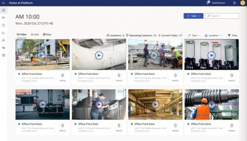
recent years, Xinyunlinke launched the "Vision AI Platform", which uses AI image recognition technology Its main
functions include real-time AI streaming It has four major functions detection, event notification, defining
customer-specific AI models and continuous learning In the real-time AI stream detection part, the Vision AI system
can use the customer's factory camera combined with the AI module to perform real-time stream detection of AI image
events It can help customers manage various operations and factory environments and keep track of them anytime and
anywhere Various work situations in terms of event notification, the Vision AI platform can provide a web version or
APP or LINE instant messaging software to provide customers with video records of the events at that time, so that the
team does not miss any events, maintains daily production capacity and reduces accidents in defining customers In
terms of exclusive AI models, a variety of basic AI models are available, including 8 detection scenarios electronic
fences, personal safety equipment, construction safety equipment, construction operations, personnel counting, screen
availability, smoke detection, pipeline corrosion and damage , illegal stacking for use in different industries,
customers can build exclusive AI models without spending time writing programs in the continuous learning part, the
Vision AI system can provide customers with the performance and accuracy of AI models, and have the ability to adapt
as the environment changes Continuous learning ability
Vision AI has a simple user interface and intuitive operation For cross-field industries, this platform has
automated and flexible AI capabilities Customers can build self-defined AI models without spending time writing
programs, and Vision AI gives AI models the ability to continuously learn and improve, allowing customers to save the
labor cost of building an AI team In addition, the platform can significantly reduce the manpower allocation for
routine inspections required for operational safety management, improve employee safety in the working environment,
and reduce on-site accidentsrisk factors at various work sites In the platform operation mode, customers can reduce
the risk of manual monitoring operations through remote operations, ensuring normal work operations and uninterrupted
production operations They can also review high-risk operating situations and collect data to assist in the planning
and correction of operating processes In addition, in order to ensure that customers comply with government
regulations, Vision AI can help customers control the equipment and safety regulations required in different
workplaces at any time through the platform's event notification and management detection
The image analysis AI platform is used in cross-field AI image recognition technology
Generally, for industrial safety inspections in the chemical industry, most rely on the naked eye of personnel to
regularly inspect pipeline abnormalities It takes an average of 100 minutes to scan an area each time, which is
time-consuming and laborious, and the pipeline location is difficult to visually observe, which may cause Employees
are exposed to accidental risks in various work safety environments In order to reduce the pain points of industrial
safety inspections in the chemical industry, Xinyunlinke assists well-known domestic chemical industry players by
using an automated image analysis AI platform, combined with customized virtual electronic fences, and using in-plant
cameras to configure AI pipeline leakage modules , the AI automatic inspection method can effectively reduce the
abnormal detection time to less than 3 seconds In addition, cameras deployed in the factory can automatically record
inspection schedules to achieve full-time monitoring, allowing customers to instantly discover and fully control
pipelines, minimizing risks In addition, the automated image analysis AI platform can help customers apply fire
warnings in factories It is conservatively estimated that the return on investment can be less than 9 months to pay
back the investment The longer the platform is used, the higher the cost-effectiveness
Build an automatic learning image analysis AI platform for Mobility as a Service in various fields
Xie Yuanbao observed that the biggest challenge facing the entrepreneurial culture of software companies in Taiwan is
that young new entrepreneurs or employees in Taiwan do not understand the entrepreneurial model and lack the awareness
to regard themselves as part of the company owners This has caused It is a pity that your future is unclear or you
have a past-experience mentality that prevents you from staying competent in a new start-up company for a long time I
believe that the essence of true entrepreneurship lies in every employee rolling up their sleeves and working hard, so
that they can truly enjoy the fruits of entrepreneurial profits Otherwise, for young entrepreneurs or employees who
often change tracks, it will be like a rolling stone that gathers no moss , I am unable to take a deep root on the
road of entrepreneurship, and I lose my ability to solidly accumulate financial independence
Regarding the business promotion challenges of Xinyun Linke, Xie Yuanbao said with emotion that because the Taiwan
market does not have a deep understanding of AI software applications, it relies more on open source AI visual
analysis or machine learning and other resources on the market, but in fact These AI technology resources are limited
in their ability to support customers' AI model needs, resulting in uneven quality of AI visual analysis software in
the market Therefore, the impact is more indirect on Xinyunlinke's ability to truly provide customers with
professional and data-centric AI image analysis services, and it also reduces the company's original business value in
customer reference In terms of technical research and development challenges, the visual analysis AI platform cannot
rely solely on AI model experts It must gather talents in various fields such as cloud, machine learning, data
science, front-end and back-end and other professional team combinations to make the platform operate successfully
Xie Yuanbao said that he believes that only through the automatic learning of the visual analysis AI platform,
automatic fast and accurate data processing capabilities, and providing customers with complete AI solution services
in the cloud, cloud ground Hybrid to pure ground, can we truly Convince customers and stand out from the
competition
Looking to the future, Xie Yuanbao hopes that Xinyunlin Technology can build an image analysis AI platform for
Mobility as a Service to automatically learn in various fields such as self-driving cars, smart warehousing robots,
and unmanned buses in smart cities At the same time, I am also grateful to the support of the Industrial Bureau of
the Ministry of Economic Affairs for the smooth landing of Xinyunlin Technology in Taiwan and the opportunity to
recruit talents from all walks of life to work together In the short-term layout, the company will actively cooperate
with domestic players such as Hon Hai and TSMC to implement image analysis AI technology in fields such as
self-driving cars, smart industrial safety, and smart warehousing robots In the medium to long term, Xinyunlinke will
target the United States, Europe, Japan and other countries as its global market layout, establish investment and
cooperation partnerships with major international companies such as Microsoft, and replicate its successful experience
and promote it internationally
Xinyunlinke official website
Xie Yuanbao, founder and chairman of Xinyunlinke
「Translated content is generated by ChatGPT and is for reference only Translation date:2024-05-19」


.jpg)


