:::

【2020 Application Example】 Dynamic License Plate Recognition System: Time-Saving and Convenient for Management

Jiude Songyi Company, with 40 years in motor-related equipment manufacturing, introduced a dynamic license plate recognition system with an accuracy rate of 98.9% to effectively monitor vehicles entering and exiting the factory area. The system uses AI technology, making vehicle management both time-efficient and effortless.

License plate recognition systems are a fundamental application of intelligent image analysis. Using cameras to capture images of license plates, the system then analyzes and processes these images to recognize the plates. Kangqiao Technology, established in 2008 by a team of LED developers and software engineers, specializes in LED product applications, developed license plate recognition and Etag integrated systems, primarily for domestic and international public works projects.

Recently, the III AI Team collaborated with the Taiwan Energy Technology Service Industry Development Association to explore real-world applications of license plate recognition technology. They identified three major issues faced by Jiude Songyi Company at this stage:

1) Currently, the company gate has no barrier machine or other control equipment. Vehicle entry and exit rely entirely on manual control and recording. If no personnel are present, vehicle movements cannot be controlled

2) When issues arise, the existing surveillance system has to slowly search for data to locate the problematic vehicle, which is very time-consuming and inconvenient

3) When the footage is found, it is often difficult to clearly identify the license plate, and even if found, it is not possible to verify the vehicle owner

Solving Three Major Problems, Providing Four Major Functions

After understanding the actual needs of the enterprise, according to the license plate recognition system architecture established by Kangqiao Technology, real-world validation was conducted on-site, with monitoring computers set up in the control room.

Kangqiao Technology License Plate Recognition System Architecture

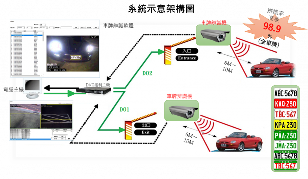
▲ Kangqiao Technology License Plate Recognition System Architecture

After installation, the main functionalities of the license plate recognition system are as follows:

1) When vehicles enter or exit, high-resolution smart cameras can identify license plates and capture images, recording the license number and vehicle status

2) When file retrieval is needed, vehicle data can be searched by time or license plate information, allowing quick access to the required video files, saving considerable time

3) The use of high-resolution smart cameras significantly improves image quality, which helps in clear identification in case of incidents

4) With registered license plate data, a blacklist and whitelist database can be set up, facilitating the management by security personnel

The advantage of license plate recognition is that it fully automates vehicle entry and exit control, reducing labor costs. The software helps to prevent misuse of license plates and eliminates the issues of remote control, induction buckle loss, and borrowing by unauthorized persons. Vehicles can enter and exit without using a remote control or rolling down the window. The long-distance license plate recognition allows gates to open while the vehicle is still moving, eliminating the waiting time for parking.

Kangqiao Technology License Plate Recognition System Setup in the Management Room

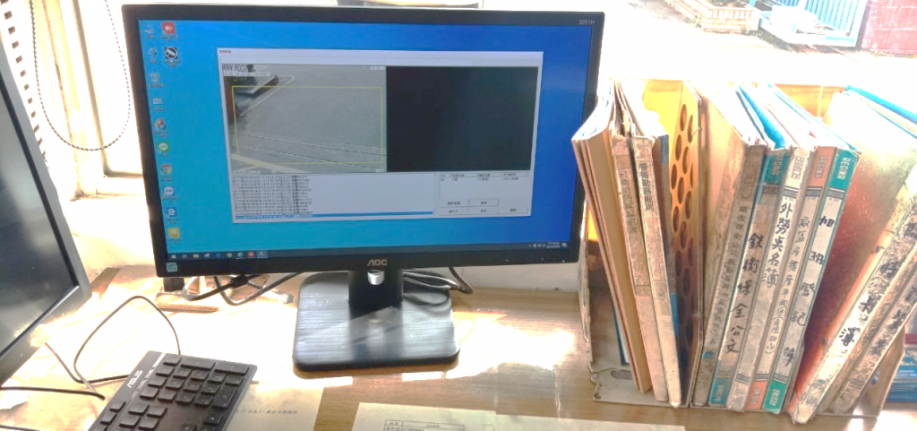
▲ Kangqiao Technology License Plate Recognition System Setup in the Management Room

The III AI Team states continually collaborating with relevant associations, from identifying corporate needs, setting topics, linking teams, introducing real-world validations, to systematically assisting enterprises in need to adopt AI technology and solve industrial problems, aiming for the AI transformation of industries. In the future, it will continue to help enterprises harness technology tools to overcome business challenges.

「Translated content is generated by ChatGPT and is for reference only. Translation date:2024-05-19」

Recommend Cases

【導入案例】巨量遙測空間數據AI分析雲端服務平台 使衛星遙測影像順利落地應用
AI Analysis Cloud Service Platform for Remote Sensing Big Data Enables the Smooth Application of Satellite Remote Sensing Images

Although satellite remote sensing images can make all surface objects visible, it still requires a lot of time and manpower to be truly applied to the industry In order to effectively solve the problems that customers face in digesting huge amounts of image data and eliminate technical obstacles for cross-domain users to process satellite remote sensing images, ThinkTron has developed an "AI Analysis Cloud Service Platform for Remote Sensing Big Data" as a new beginning for cross-domain AI applications for spatial information In recent years, in response to the impact of industrial globalization, Taiwan's agriculture has continued to transition towards technology-based and higher quality, improving the yield and quality of crops by solving problems, such as microclimate impacts and pest and disease control The demand of agriculture on images has expanded endlessly to accurately grasp the growing environment of crops In the early years when UAVs unmanned aerial vehicles were not yet popular, manual field surveys were the most basic but most labor-intensive work With the emergence of UAV drones, aerial photography operations might not be difficult, but the range that can be photographed is limited Furthermore, surveying expertise is required to accurately capture spatial information At this time, the use of satellite remote sensing data may break away from the past imagination of using image data Taiwan Space Agency TASA ODC data warehouse services In the past ten years, with the breakthrough of modern satellite remote sensing application technology, Digital Earth has become a new trend in global data collection Countries have developed data cube image storage technology, and the development of smart agriculture has become one of the largest image users Determining planting distribution is the first step in understanding crop yields Free satellite remote sensing images, powerful data warehousing support, and the team's robust image recognition technology are important supports for accelerating agricultural transformation Using satellite remote sensing image data can accelerate the development of smart agriculture However, in the past, it was difficult to extract large-area crop distribution through satellite remote sensing images, not to mention the cost If you wanted to use free information, you had to visit all websites of international space agencies, look through the wide variety of satellite specifications, and carefully evaluate the sensor specifications, image resolution, and revisit cycle After finding suitable images, you had to look at them one by one to filter the ones you need Next is downloading dozens of images that are often several hundreds of Megabytes MB each, which might exceed the capacity of your computer Also, after overcoming image access and preparing data, you must then start to confirm the downloaded image products and which bands you want, because the image you see is not just an image file jpg or png, but rather complex multi-spectral information, attribute fields and coordinate information It takes a lot of effort just to confirm the correct information Facing GIS software packages with complex functions is the start of another trouble The complex image pre-processing process and the inflexible machine learning package greatly reduce the efficiency of analyzing data After finally getting the results of crop identification, you might find that the best time for using map information may have already passed The above-mentioned complex and time-consuming satellite image processing problems are precisely the pain points of the market ThinkTron expanded from traditional machine learning to modern deep learning applications, and developed an "AI Analysis Cloud Service Platform for Remote Sensing Big Data" under the GeoAI framework, breaking through the constraints of details in the spatial information for customers Differences between the process before and after introducing the AI analysis cloud service platform ThinkTron said that Taiwan's ODC Open Data Cube system has been completed and began providing services after years of efforts from the Taiwan Space Agency TASA, formally becoming aligned with international trends The powerful warehousing technology allows users to easily capture and use image data of a specific time and spatial range according to their needs The warehouse stores multiple satellite image resources from international space agencies, including the ESA's Sentinel-1 one image every 6 days, Sentinel-2 one image every 6 days, USGS's Landsat-7 one image every 16 days, Landsat-8 one image every 16 days, and the domestic Formosat-2 one image every day and Formosat-5 one image every 2 days ThinkTron develops satellite image recognition tools based on Python Breaking free from the limitations of GIS Geographic Information System software packages, ThinkTron integrated GDAL Geospatial Data Abstraction Library based on Python, and considered computing efficiency and parallel processing when developing all tools required for satellite image processing and image recognition modeling, including coordinate system and data format conversion, grid and vector data interaction, and data intra-difference and normalization All of the tools are designed with AI applications in mind, and some commonly used tools are packaged into an open source package under the name TronGisPy to benefit the technical community ThinkTron utilized the team's understanding of satellite remote sensing images and the collected tagged data crop distribution maps to preset the image recognition modeling process, the required training data specifications, and dataset definitions This is imported into the machine learning LightGBM or deep learning CNN framework that was completed in advance, and the entire training process to be performed in the Web GIS interface, providing users with partial flexibility to freely filter images, confirm spatial and temporal ranges, select models, and adjust hyperparameters In addition to the operation of training models, it also provides historical models to output identification results, and finally displays the identification results of crop distribution on the Web GIS map In fact, agriculture is not the only industry that needs satellite remote sensing applications AI applications of spatial information have also appeared in various fields as companies in different industries aim to enhance their global competitiveness For example, surveying and mapping companies that have a large amount of map data can use the AI analysis cloud service platform to store map data while also accelerating the efficiency of digital mapping Under the severe global climate change and the risk of strong earthquakes, there is a wide variety industrial insurance, agricultural insurance, financial insurance, or disaster insurance are all inseparable from spatial information The use of remote sensing image recognition to understand insurance targets has long been an international trend AI Analysis Cloud Service Architecture for Remote Sensing Big Data

【導入案例】化身大型AIOT科技遊樂場 海科館華麗轉身好吸睛
Transforming into a Large-Scale AIoT Technology Playground: The Spectacular Makeover of the National Museum of Marine Science & Technology

Taiwan is a maritime nation When you visit the Badozi Fishing Port or Tidal Park in Keelung, do you also explore the mysteries of the ocean world at the 48-hectare National Museum of Marine Science amp Technology To get more people closer to marine technology, Keelung's Marine Museum has introduced technological services, transforming the venue into a large technology playground that delights both children and adults, fully utilizing the 'learning through play' approach After a lengthy planning process, Northern Taiwan's largest marine science museum in Keelung opened in January 2014 The museum focuses on marine education and technology, boasting Taiwan's largest IMAX 3D ocean theater The unique themes and modern viewing facilities should make it a well-known landmark in Keelung However, the original exhibition planning was static and highly specialized, lacking sufficient interaction with the public Visitors who have attended the museum also reported that the exhibits were limited and quite boring, leading to poor overall consumer experience ratings The top three dissatisfactions with the museum were weak connections to surrounding attractions, unengaging display content, and lack of exhibit material According to statistics from the Marine Museum, the ratio of local to visiting guests is approximately 64, with most foreign visitors coming from the north transportation is primarily by car and bus common types of visits include family, parent-child, and friends and the stay duration is generally 1 to 2 hours Upon deeper investigation, the top three visitor complaints were weak linkages to surrounding attractions, unengaging display content, and insufficient number of exhibits The museum analyzed potential reasons, including some displays being too specialized, making it difficult for the public to understand, and a lack of interactive elements, making the exhibition boring and the visit hurriedly brief Analysis of visitor profiles revealed that since half of the museum's visitors are locals, and accessing the museum is not so easy for out-of-towners who must travel by car or public transport, the design of the venue and exhibitions must incorporate more interactivity and intrigue to encourage locals to return and extend the duration of visitors' stays while using technological services to highlight the museum's unique features Through a recommendation from the Information Software Association, part of the Ministry of Economic Affairs' Industrial Bureau AI team, the Marine Museum commissioned Jugu Technology to resolve the issue of uninspiring venue attractions Preliminary interviews by Jugu Technology revealed that many visitors were attracted by the architectural design of the museum, notices posted on nearby walls, flags, or events being held the most interesting feature for visitors was the 3D ocean theater, indicating that content presented through audio-video and physical scenic methods was more engaging Seven major AI technologies lead to a boost in regional tourism at the Marine Museum Through the introduction of technology services, Jugu Technology designed the 48-hectare site with seven major services AI voice tours, treasure hunt puzzle games, AI exhibit interactive revitalization, AI space exhibition interactive experience, AI crowd control, Face AI interactive experience, and AI voice customer service system By utilizing AIoT and cloud technology, they made the exhibition more interesting, not only solving the issue of boring static viewings for children but also doubling the learning efficiency and dramatically improving public perception of the Marine Museum, thus increasing visitor intent and boosting regional tourism The National Museum of Marine Science and Technology introduced seven major technological application services including AI voice guide Jugu Technology aimed to improve the space optimization of the Marine Museum, using the special exhibition of coastal birds in northern Taiwan as a prototype, integrating 'face', 'limb', 'crowd' as three main axes to enhance functionality and assist in improving the museum's application of AI Practically, the Marine Museum and Jugu Technology selected the on-site special exhibits to avoid any installation of water and electricity works or pipelines in active exhibits, thereby maintaining the quality of the viewing experience Instead, they selected exhibits that were not yet open to introduce a series of technological services tailored to the unique characteristics of the exhibits In the coastal bird special exhibition inside the Marine Museum, initial construction discussions with the curators utilized Bella X1 for a welcoming interactive introduction at the exhibition entrance This was followed by an AI-powered smart guide in both Chinese and English using X1 for narration, coupled with a fun treasure hunting stamp-collecting activity - APP X1, allowing visitors to participate in challenges Subsequently, bird species within the bird exhibition were brought to life interactively using X1, and AR scenarios X1 were introduced into the exhibition space to add elements of fun and entertainment Finally, Face AI was used to interactively test facial expressions and score smiles The gorgeously transformed Marine Museum will become the best travel destination for families with children ImageMarine Museum FB Page The AIoT services introduced by the Marine Museum could be extended to various exhibition-type museums and even static art galleries in the future, tailored to the unique characteristics of different venues They could also be promoted through government projects and related plans, aiding in rural revitalization, making visits more than just sightseeing in rural areas, and breaking free from stereotypes associated with different venues The applications of these services are broad「Translated content is generated by ChatGPT and is for reference only Translation date:2024-05-19」

這是一張圖片。 This is a picture.
AI Assists the Red Cross for Smarter Emergency Response

More Preparation Less Loss The Taiwan Food Bank Association, a non-profit organization, collects donations daily from wholesalers, retailers, manufacturers, and even kind-hearted individuals across Taiwan They also rescue consumable materials that are about to be discarded, properly allocate and deliver to households in need, aiding local underprivileged populations When natural disasters such as earthquakes, landslides, mudslides, typhoons, floods, and droughts occur in Taiwan, the food bank's resources can be immediately deployed for disaster relief This field verification unit is the Nantou County Red Cross AssociationOne of the food bank locations, hereinafter referred to as the Nantou Red CrossIs responsible for tasks like pre-disaster supplies preparation and disaster relief material distribution, helping the government bear the responsibility of disaster relief and aid In Taiwan, various natural disasters have characteristics of different duration and spatial coverage, wide or narrow With the normalization of extreme weather, the scale and number of disasters are gradually increasing and becoming harder to predict The required amount and type of materials differ by disaster, and they must address the lifestyles of the affected areas, rescue needs, traffic conditions, geographical restrictions, and other factors for varied material allocation, facing numerous challenges Typhoon Kanu severely damaged transportation in Nantou mountain areas Nantou County Red Cross planned the mountainous route Puli gt Fazhi Elementary School gt Qin'ai Village gt Aowanda to deliver supplies Disasters happen repeatedly We need to be prepared at all times Effective disaster preparedness can mitigate the impact, including swift response to material needs in affected areas, aid distribution, and even psychological support, providing added security for life and property of those in disaster zones Lack of Timeliness in Disaster Information To improve the living conditions and address the lack of supplies in remote areas, the Taiwan Food Bank Association has partnered with the Nantou Red Cross and has successively established food bank points in Nantou City, Puli, and Ren'aiLixing, Ruiyan, XinyiWangmei, Tongfu, Shuili, Lugu and Caotun among others9establish food bank locations, providing supplies worth a certain amount per household every month6001000in New Taiwan Dollars However, many challenges still need to be overcome during natural disasters For example, when typhoons, earthquakes, and landslides occur, the information source for disaster relief dispatch systems relies on post-disaster reports The time lag between reporting, response, and execution prevents timely adjustment and distribution of 'disaster relief' supplies based on the needs of affected areas, affecting rescue efficiency due to lack of timely information The 'preparedness' supplies of the Nantou Red Crosssuch as dry food, water, instant noodles, etc,are recorded manually in terms of stock, expiration dates, and distribution,When a disaster occurs, there is a chance that 'preparedness' supplies have expired and cannot become 'disaster relief' supplies It’s also possible that both conditions mentioned above occur simultaneously, leading to a need for more time to reassign 'preparedness' supplies into usable 'disaster relief' materials On the other hand, upon receiving information about shortages in disaster areas, the supplies donated by the public often grossly differ from the actual needs of the disaster zone, leading to an excess of supplies The Process of Material Operations Before and After a Natural Disaster AIAnticipating Natural Disasters Reinforcing the Accuracy of Preparedness Material Dispatch Application API Technology connects to compute the state of the climate, the intensity of disaster rescues, prioritizing the main tasks of the Nantou Red Cross and the needed areas of search and rescue Coordinated with the existing heavy rain and typhoon simulation disaster training of the Nantou Red Cross, a 'Natural Disaster Emergency Preparedness Material Dispatch and Supplement Decision System' is establishedreferred to as the Emergency Preparedness Material System。 In material management, inventory data along with immediate supply data are entered into the Emergency Preparedness Material System for comparison and analysis, helping the Nantou Red Cross quickly recognize materials like cookiesdry food, beverages, frozen food, toilet paper, etc, and determining whether they should be 'preparedness' materials or regularly distributed materials Adding to this, information forecasting understands the potential disaster conditions in remote areas, facilitating food delivery, addressing both front-end food wastage and backend practical needs When a natural disaster occurs, it enables faster response and decision-making, completing material deployment, hence increasing the speed of material operation transition20。 AI Emergency Preparedness Material System Helps Rapidly Adapt Material Distribution Through the field verification of the Nantou Red CrossAIthe system, material management, and related applications are promoted to more emergency response organizations in different areas, while continuously improving the alert functions within the Emergency Preparedness Material System, strengthening the technological foundation for alerts, enhancing prediction accuracySystem immediacy, and optimizing the data collection and analysis process Simultaneously, it can collaborate with government agencies, meteorological departments, or other rescue teams to discuss integrating more data sources, establishing a mechanism to share resources and data promptly, sharing information in real-time, helping more emergency response organizations enhance their disaster response abilities, seizing the golden rescue time 「Translated content is generated by ChatGPT and is for reference only Translation date:2024-12-12」