:::

【2020 Application Example】 AI data analysis platform for enterprise patent monitoring, complete patent analysis and development trends with one click!

How to efficiently analyze the massive growth of patent information and tap potential value?

Patents are a valuable source of technology, market and competitive information. However, the total number of published patent documents has reached 120 million, with 6.3 million new ones added last year alone. How can we make these massive patent documents available for our own use?

Patent analysis provides an indispensable and practical way to fully tap the value of patent information. Through patent analysis, you can understand the strengths, weaknesses, and opportunities of your own and your competitors' respective patent portfolios, as well as global patent application trends, technology panorama, and possible blank areas.

However, patent analysis requires a thorough understanding of the underlying data, including: the usage and purpose of the data, as well as the problems that can be solved, etc. How to effectively use and analyze massive information is the most troublesome problem...

Unstructured data types can only be read and organized manually, which is very annoying!

"Patent specification" is a legally binding document that combines legal and scientific terms. It is unstructured data. In the past, various search and analysis methods were manually read and organized, which was time-consuming and time-consuming. It often happens that we are unable to keep up with the litigation schedule. When assisting enterprises in patent layout, they often face the difficulty of quantifying the degree of litigation risks faced by competitors and customers, as well as the quality and value of patents. This results in the inability of a domestic enterprise intellectual property management company to further expand its business scope and to promote the outside world. Knowledge of patented value-added applications.

In recent years, enterprise intellectual property management companies have also begun to assist R&D personnel in enterprises to master important technologies and patent competition intelligence that will affect the future development of the industry in advance, allowing relevant personnel to more calmly carry out patent layout and improve patent quality. and value. However, most of the business scope is in the agency of patent software, such as: Intellectual Property Operation Management Information System (IPServ), which mainly assists companies or individuals in managing intellectual property rights, but currently does not provide "patent monitoring" data analysis for companies or individuals. services.

Intellectual Property Operation Management Information System (IPServ )

▲Intellectual Property Operation Management Information System (IPServ)

These patent software include patent retrieval, management and maintenance, etc. Whether patent big data can successfully assist companies in understanding market conditions, patent value, litigation threats and monitoring competitors' illegal infringements all depends on the acquisition of patent data. . However, cleaning patent data is very time-consuming, so it has always been a headache. It was not until Taiwan Data Science Co., Ltd. developed the "AI Data Analysis Platform for Enterprise Patent Monitoring" that the light finally appeared...

Traditional patent analysis is time-consuming and time-consuming. Instead, use the "AI Data Analysis Platform for Enterprise Patent Monitoring" to get it done with one click!

The idea of ​​"AI Data Analysis Platform for Enterprise Patent Monitoring" is to use discriminating influencing factors such as "patent code" and "company industry type" in patent application cases, through big data analysis, and Add relevant news information, and then use machine learning to assist experts through AI to analyze the current market situation, avoid the threat of lawsuits, and monitor competitors' illegal infringements.

These finally extracted factors will also affect the performance of individual stocks. For this, according to different corporate attributes and development directions, "customized big data analysis" can be used to enhance the strategic position of the company. It is hoped that the search through the platform can quickly allow companies to understand the patent layout of competitors when adding new product lines to avoid infringement; or when manufacturers are looking for partners, they can also filter from companies with advanced R&D and This platform serves as a great tool for co-opetition relationships.

System operation flow chart

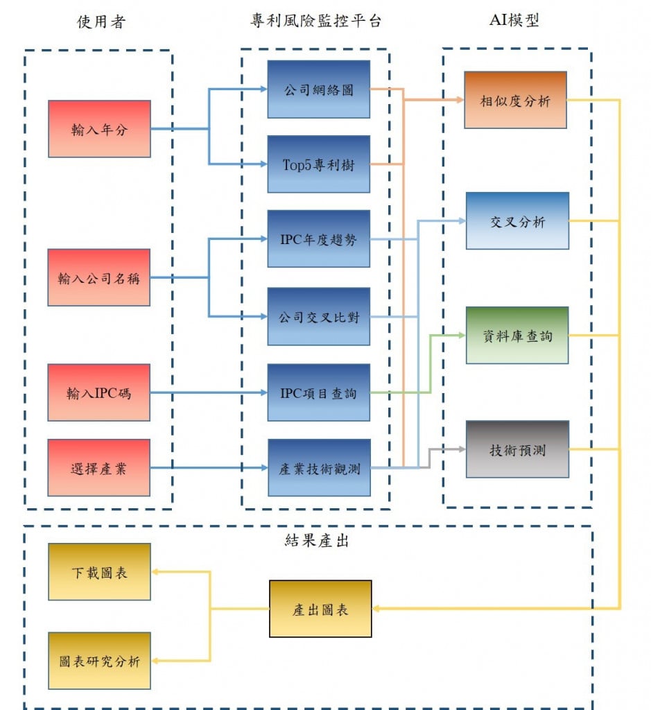
▲System operation flow chart

Traditionally, patent analysis is time-consuming and requires manual searching of patents and reading patent information to produce a patent analysis report. Now, through the "Enterprise Patent Monitoring Data Analysis Platform", users can enter After systematic analysis of the company names of your own company and that of your competitors in a certain year, you can quickly know the technical layout, change trend monitoring and other results of that year and among companies, saving work time and manpower.

For example, if you want to know the current development status of related technologies in physics, chemistry, and electricity on the market, you can analyze the IPC patent numbers and check which companies have clusters of patents, so as to determine whether the clustered patents are relevant. Technology or interdependent technology, understand the similarities in patent layout and industry trends between companies, shorten decision-making time, preemptively lay out or make patent avoidance designs.

Using artificial intelligence to improve traditional manual patent search operations to improve work efficiency, the "Patent Monitoring Platform" helps patent analysts more easily understand the current status of patent development in specific technical fields to predict future technology research and development directions. "Patent layout" is when an enterprise builds a strict protection network for its patent portfolio by integrating market, industry, legal and other factors to form a favorable research and development direction and reduce the risk of infringement.

A rigorous patent layout can help companies avoid landmines in strategic planning and avoid unnecessary litigation; or they can expand the scope of protection of their own technology by applying for patents and purchasing patents first. To achieve this goal, The key is to identify trends ahead of peers by analyzing a large amount of patent information. Taking the product line people flow information flow antenna developed by our company as an example, the patent monitoring platform can achieve the above goals based on the patent portfolio of the product.

People flow information flow antenna product picture

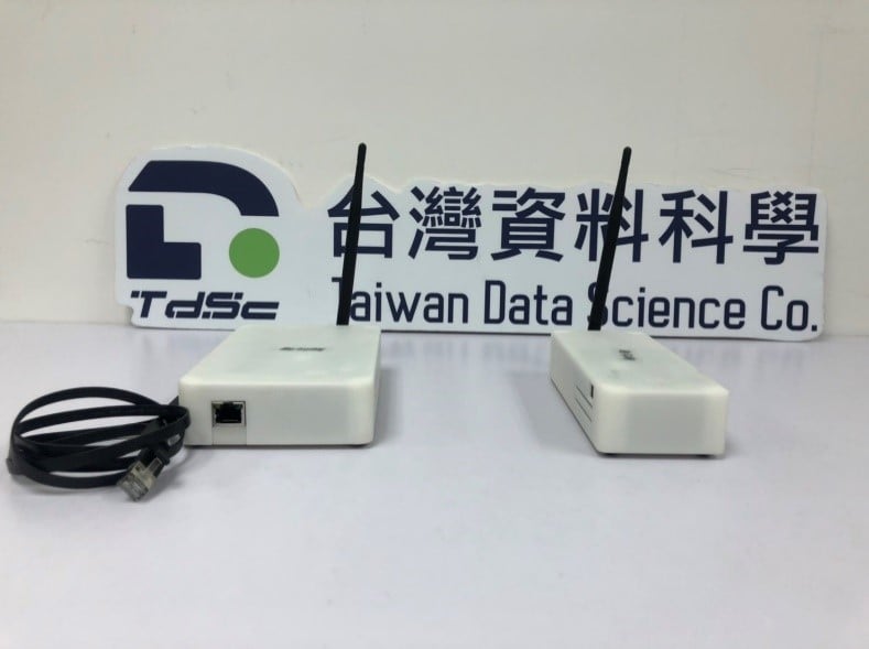
▲People flow information flow antenna product picture

In the future, text mining (Text Mining) will be conducted on the titles and abstracts of patent document contents. Manual assistance was provided in the early stage, and machine learning was adopted in the later stage to establish a "patent thesaurus automatic word segmentation system". Use this word segmentation system to segment titles and abstracts, and calculate word frequency (TF) and inverted document frequency (IDF). Through statistical methods (such as correlation numbers), the characteristics of patent documents are extracted to find related words with strong correlation between patents. Improve the similarity of exploration patents and better understand the risks of patent litigation.

Collaborate with patent industry players to create a more convenient "Enterprise Patent Monitoring AI Data Analysis Platform"!

By querying the "Platform Network Diagram" of the "Enterprise Patent Monitoring AI Data Analysis Platform", a company or firm can quickly see which patents its related industry companies are laying out. As for "patents", each company can consider whether to apply for all its own research and development, or directly purchase a separate patent license from an industry leader. For "company products", when it comes to commercialization, different strategies can be adopted in response to the changes of the times. They may have been enemies in the past few years, but with the differences in product development, they are allies today.

Patent monitoring platform displays 2009 Network diagram of Largan Optoelectronics and its related industries

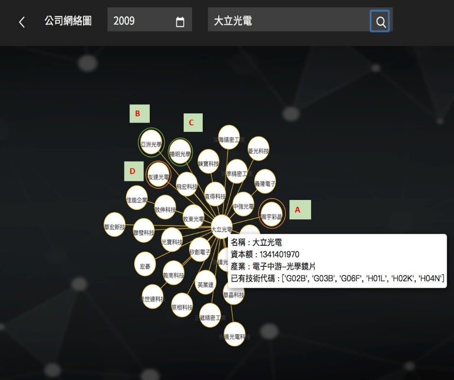
▲The patent monitoring platform displays the network diagram of Largan Optoelectronics and its related industries in 2009

In the "Company Cross Comparison" function query, you can select multiple years at a time. For comparison companies that are highly similar to major companies, you can learn from the annual changes whether the two parties have developed too similar patents, which will make the two companies Being in the middle of a storm of high-risk infringement. When there is more data in the database, the "patent risk rate" can be further calculated, allowing users who are accustomed to reading numbers or charts to quickly understand each other and themselves from another perspective. Even if more parameters are added in the future, the "amount of infringement" can be estimated. However, to obtain the parameter content, it is necessary to cooperate with the patent industry to create a more convenient patent risk monitoring platform.

TSMC and Huaya Technology, Trend chart of similarity indicators between Powerchip Technologies

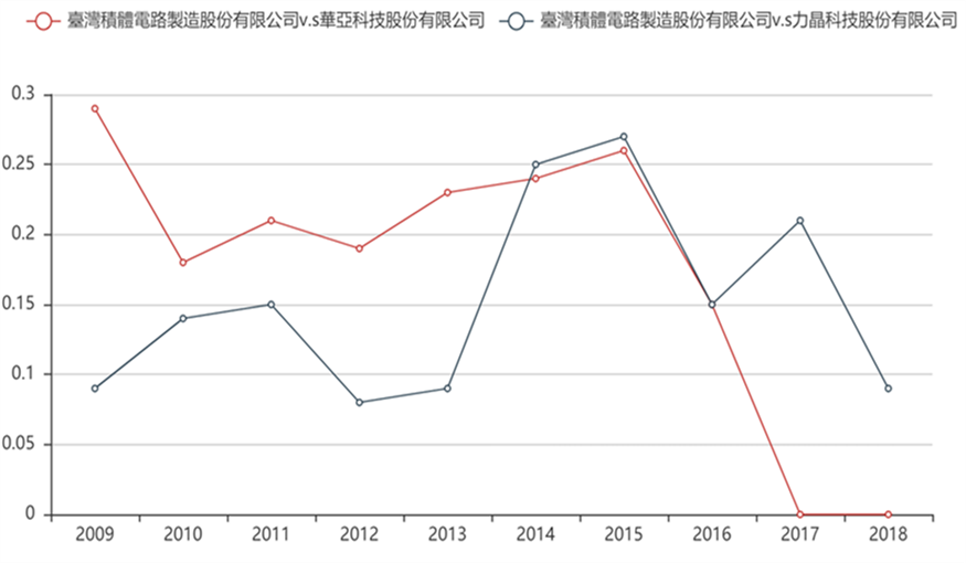
▲Trends of similarity indicators between TSMC, Huaya Technology and Powerchip Technology

「Translated content is generated by ChatGPT and is for reference only. Translation date:2024-05-19」

Recommend Cases

【導入案例】巨量遙測空間數據AI分析雲端服務平台 使衛星遙測影像順利落地應用
AI Analysis Cloud Service Platform for Remote Sensing Big Data Enables the Smooth Application of Satellite Remote Sensing Images

Although satellite remote sensing images can make all surface objects visible, it still requires a lot of time and manpower to be truly applied to the industry In order to effectively solve the problems that customers face in digesting huge amounts of image data and eliminate technical obstacles for cross-domain users to process satellite remote sensing images, ThinkTron has developed an "AI Analysis Cloud Service Platform for Remote Sensing Big Data" as a new beginning for cross-domain AI applications for spatial information In recent years, in response to the impact of industrial globalization, Taiwan's agriculture has continued to transition towards technology-based and higher quality, improving the yield and quality of crops by solving problems, such as microclimate impacts and pest and disease control The demand of agriculture on images has expanded endlessly to accurately grasp the growing environment of crops In the early years when UAVs unmanned aerial vehicles were not yet popular, manual field surveys were the most basic but most labor-intensive work With the emergence of UAV drones, aerial photography operations might not be difficult, but the range that can be photographed is limited Furthermore, surveying expertise is required to accurately capture spatial information At this time, the use of satellite remote sensing data may break away from the past imagination of using image data Taiwan Space Agency TASA ODC data warehouse services In the past ten years, with the breakthrough of modern satellite remote sensing application technology, Digital Earth has become a new trend in global data collection Countries have developed data cube image storage technology, and the development of smart agriculture has become one of the largest image users Determining planting distribution is the first step in understanding crop yields Free satellite remote sensing images, powerful data warehousing support, and the team's robust image recognition technology are important supports for accelerating agricultural transformation Using satellite remote sensing image data can accelerate the development of smart agriculture However, in the past, it was difficult to extract large-area crop distribution through satellite remote sensing images, not to mention the cost If you wanted to use free information, you had to visit all websites of international space agencies, look through the wide variety of satellite specifications, and carefully evaluate the sensor specifications, image resolution, and revisit cycle After finding suitable images, you had to look at them one by one to filter the ones you need Next is downloading dozens of images that are often several hundreds of Megabytes MB each, which might exceed the capacity of your computer Also, after overcoming image access and preparing data, you must then start to confirm the downloaded image products and which bands you want, because the image you see is not just an image file jpg or png, but rather complex multi-spectral information, attribute fields and coordinate information It takes a lot of effort just to confirm the correct information Facing GIS software packages with complex functions is the start of another trouble The complex image pre-processing process and the inflexible machine learning package greatly reduce the efficiency of analyzing data After finally getting the results of crop identification, you might find that the best time for using map information may have already passed The above-mentioned complex and time-consuming satellite image processing problems are precisely the pain points of the market ThinkTron expanded from traditional machine learning to modern deep learning applications, and developed an "AI Analysis Cloud Service Platform for Remote Sensing Big Data" under the GeoAI framework, breaking through the constraints of details in the spatial information for customers Differences between the process before and after introducing the AI analysis cloud service platform ThinkTron said that Taiwan's ODC Open Data Cube system has been completed and began providing services after years of efforts from the Taiwan Space Agency TASA, formally becoming aligned with international trends The powerful warehousing technology allows users to easily capture and use image data of a specific time and spatial range according to their needs The warehouse stores multiple satellite image resources from international space agencies, including the ESA's Sentinel-1 one image every 6 days, Sentinel-2 one image every 6 days, USGS's Landsat-7 one image every 16 days, Landsat-8 one image every 16 days, and the domestic Formosat-2 one image every day and Formosat-5 one image every 2 days ThinkTron develops satellite image recognition tools based on Python Breaking free from the limitations of GIS Geographic Information System software packages, ThinkTron integrated GDAL Geospatial Data Abstraction Library based on Python, and considered computing efficiency and parallel processing when developing all tools required for satellite image processing and image recognition modeling, including coordinate system and data format conversion, grid and vector data interaction, and data intra-difference and normalization All of the tools are designed with AI applications in mind, and some commonly used tools are packaged into an open source package under the name TronGisPy to benefit the technical community ThinkTron utilized the team's understanding of satellite remote sensing images and the collected tagged data crop distribution maps to preset the image recognition modeling process, the required training data specifications, and dataset definitions This is imported into the machine learning LightGBM or deep learning CNN framework that was completed in advance, and the entire training process to be performed in the Web GIS interface, providing users with partial flexibility to freely filter images, confirm spatial and temporal ranges, select models, and adjust hyperparameters In addition to the operation of training models, it also provides historical models to output identification results, and finally displays the identification results of crop distribution on the Web GIS map In fact, agriculture is not the only industry that needs satellite remote sensing applications AI applications of spatial information have also appeared in various fields as companies in different industries aim to enhance their global competitiveness For example, surveying and mapping companies that have a large amount of map data can use the AI analysis cloud service platform to store map data while also accelerating the efficiency of digital mapping Under the severe global climate change and the risk of strong earthquakes, there is a wide variety industrial insurance, agricultural insurance, financial insurance, or disaster insurance are all inseparable from spatial information The use of remote sensing image recognition to understand insurance targets has long been an international trend AI Analysis Cloud Service Architecture for Remote Sensing Big Data

【解決方案】優式AI智能割草機器人 搶攻高爾夫藍海市場
USRROBOT's AI Lawn Mowing Robot Enters the Blue Ocean of Golf Market

An AI smart lawn mowing robot, resembling a vacuum robot, shuttles back and forth on the 30-hectare golf course lawn for weeding This robot, independently developed and designed by Taiwanese, is equipped with the world's first electronic fencing positioning technology which utilizes high-precision GPS integrated with cloud AI computation to determine the most efficient mowing paths, targeting the lucrative blue ocean market of golf courses This AI lawn mowing robot was developed by USRROBOT, a Taiwanese startup established in 2019 Chao-Cheng Chen, the president of USRROBOT, once served as the executive vice president of one of the top five ODM tech companies in Taiwan, and specializes in software and hardware integration When he served as the chairman of the Service Robot Alliance, he knew that the service robot industry was bound grow rapidly due to declining birth rates and the growingly severe labor shortage New demand - The horticulture market is large and the has rigid demand "To develop the core technology of service robots, we must find rigid demand Looking at European and American countries, there is a shortage of labor, but demand for horticulture has increased, and there has been a long-term shortage of 7-10 of horticultural workers" Under this strong "rigid demand," Chao-Cheng Chen established USRROBOT, and the company's first product is the AI lawn mowing robot In terms of overseas markets, the United States is the world's largest horticulture market, accounting for 30-40 of the global output value It is estimated that there are about 1 million horticulture workers, but they have been experiencing a labor shortage of 7-10 in recent years and have not been able to improve the situation The main reasons for labor shortage are Aging population and gardening is a labor-intensive job, so young people don't want to do it Unlike in Taiwan, European and American countries attach great importance to lawn maintenance and have expressly stipulated in the law that heavy fines will be imposed for failing to mow the lawn Therefore, the AI lawn mowing robot has considerable market development potential The introduction of AI multi-device collaborative mowing sensor technology is expected to reduce the burden of staff maintaining the golf course The AI lawn mowing robot developed by USRROBOT is currently in its second generation Domestic universities and well-known art museums are using the latest model M1, and it is also being used by some world-renowned high-tech companies and well-known universities in the United States The company is currently involved in negotiations for subsequent business cooperation USRROBOT stated that the professional RTK system currently used can reduce the original GPS positioning error from tens of meters to about 2 centimeters, allowing the robot to move accurately outdoors After setting the boundaries, it can be easily operated using the app New application - Implementation in golf courses solves the problem of labor aging and shortage Chao-Cheng Chen further explained that the National Land Surveying and Mapping Center is a RTK service provider RTK provides the error reference map of the positioning point USRROBOT can access the positioning error value of a specific position through 4G Internet access The AI algorithm of USRROBOT reduces the general 10-20 m error of GPS to 2 cm After positioning, USRROBOT then uses six-axis accelerator positioning, gyroscopes, and wheel differential sensing devices for software and hardware integration Only by matching the wheel's movement pattern and the terrain can accurate mowing path planning be achieved The AI lawn mowing robot, which is 62 cm wide, 84 cm long, 46 cm high, and weighs only 25 kg, can set the mowing boundaries in the cloud It can avoid pools and sand pits through settings, using AI algorithms to automatically calculate the optimal path It is able to mow approximately 150 ping of grass in one hour The battery can be used continuously for more than 6 hours The battery life is currently the highest in the world In addition to general gardening companies, with the assistance of the AI project team of the Industrial Development Bureau, Ministry of Economic Affairs, USRROBOT's AI lawn mowing robot has been applied to golf course lawn mowing A well-known golf course located in Taiping District, Taichung City currently has a staff of 5 people who are responsible for the lawn, planting maintenance, and other landscape maintenance of the entire 30-hectare course However, the average age of staff is as high as 55 years old, and the golf course has been unable to recruit new staff members for a long time In view of the aging staff and the shortage of manpower, the golf course hopes to mitigate the impact with AI technology, and is therefore using AI multi-device collaborative mowing sensor technology, in hopes of reducing the burden of staff maintaining the golf course New challenges - Expert systems are needed to overcome difficulties with different grass species "This AI lawn mowing robot has low noise, low pollution, low labor costs, and is waterproof and anti-theft In the lawn mowing process, it can identify and avoid obstacles through ultrasonic sensors while maintaining mowing quality, maintaining aesthetic and consistent grass length" Chao-Cheng Chen went on to say that the most important part about golf courses is that the grass pattern should be beautiful and free from diseases and pests Based on the site survey, golf courses are mainly divided into three major areas green, fairway and rough There is no problem using the current mowing robot to mow the rough area, and it can overcome slopes within 20 degreesThe short grass in the fairway area may only be two centimeters long, and the grass types are also different, so the cutterhead design needs to be modifiedAs for the grass in the green area, the grass must be mowed close to the ground and maintained in a consistent direction because it affects the putting speed Many factors will affect the green index, and this part requires more research and testing The AI lawn mowing robot can identify and avoid obstacles through ultrasonic sensors while maintaining mowing quality The AI smart lawn mowing robot has a built-in camera that can be used to detect the health condition of the lawn Chao-Cheng Chen said that in the future, an expert system will also be introduced for early determination of whether there are diseases, pests in the lawn or whether there is sufficient moisture, and provide lawn health data analysis to customers, so that they can take preventive and response measures sooner to reduce disaster losses Chao-Cheng Chen, who is also a good golfer himself, said that golf has developed well in Taiwan However, due to weather factors, such as rainy and humid climate and typhoons, Taiwan's golf courses have harder soil and more potholes compared with top tier golf courses overseas If AI lawn mowing robots are to be widely introduced into golf courses, there are still many difficulties that must be overcome However, Taiwan's difficult terrain creates a good testing ground Once Taiwan can overcome the many problems and successfully introduce the robot, it will be able to expand to overseas markets and seize new market opportunities in a blue ocean Chao-Cheng Chen, President of USRROBOT nbsp

這是一張圖片。 This is a picture.
CCTV Intelligent Video Search System

Search for a specific person, find someone with a suitcase entering the factory in Gao'an area Color features of the person and the object confirmed, person in blue and black top, suitcase in black color, throughCCTV the intelligent video search system, by setting object and color retrieval conditions, it can successfully locate three video clips containing the target subject This greatly aids operational staff in finding the target items, and through this system, search speed can far surpass manual effort6fold Pain Points The CSE-Kaohsiung Plant is densely equippedCCTVto monitor every corner of the plant area, but when an incidenthappens, it's impossible within a limited time throughCCTVvideo playback to find the incident, the implications and risks behind this are self-evident Many areas that are usually unmanned can easily become security blind spots Thus, how to monitor a vast plant area more intelligently and effectively is one of the crucial aspects of building a smart plant for the semiconductor industry The AES Plant in Kaohsiung covers a vast area, with many important sites requiring monitoring of personnel movements to ensure corporate secrets and employee safety 1 Automated production lines and warehouses In semiconductor enterprises’ automated production lines and warehouses, oftenAGV(Automated Guided VehicleAGVs automated guided vehicles travel at high speeds if plant personnel inadvertently enterAGVthe moving area and cannot issue a warning to the person, then the regrettable accidents that occur will be too late to reverse 2 Material and product storage areas Materials used in semiconductor-related processes are costly if areas storing materials or products are breached, there is a risk of loss of high-value materialsproducts 3 High-security areas Trade secrets relate to the core technological competitiveness of semiconductor-related enterprises if someone breaches the high-security areas, there is a risk of corporate secrets being leaked The safety of trade secrets has always been one of the most critical issues for semiconductor enterprises 4 Loading docks At AESLButthe dock area often has loading vehicles coming and going if someone intrudes into the dock area, there is a risk of vehicle collisions and accidents Additionally, goods awaiting shipment at the dock area could be stolen or potentially damaged from collisions, thus causing significant reputation and financial losses for the company, further leading to production and shipping inconvenience When an abnormal event occurs, how to quickly search for the relevant key footage from massive data Many important locations within the AES Kaohsiung Plant need to be equippedCCTVfor safety checks, butCCTVWith thousands to tens of thousands of cameras, manually searching through footage for an event requires laborious frame-by-frame review which is time-consuming and inefficient In light of advancements in computer vision, it's beneficial to utilizeAIto replace manual playback and searching Problem Scenario Object Detection The data source for object detection comprises two parts Open-source datasetsOIDv4and AES Kaohsiung PlantCCTVImage files For these files, search for usable data, specificallyOIDv4image files For these files, extract the defined nine major categories of objects for training data among them, two object categories, knives and gasoline barrels, were not found inOIDv4found usable data for knives and gasoline barrels, while the remaining seven categories of objects are available fromOIDv4useful training data found for the remaining seven categories of objects, all marked Regarding the Kaohsiung PlantCCTVimage files, select some frames Frame of the footage, and manually annotate the objects to be_detected for training and testing data Nine Major Objects Color Recognition The data source for color recognition is divided into two partsInternet image screenshots, and Kaohsiung PlantCCTVimage files Currently, no publicly available open-source datasets specifically for color recognition applications have been found, so images are collected from the web Search the web for images of the defined nine major object categories, save the images after separating the objects from the background, keeping only the object sections, and mark the images according to color Additionally, for the Kaohsiung PlantCCTVimage files, use the already-markedbounding boxextractCCTVimage files from variousFramesections of objects identified by color, and finally, visually identifiable images are marked according to color Each object category has its specific color definition, depending on the usual colors seen in these objects in real life Dynamic Ignore during Training FromOIDv4during the training of the object detection pilot model, since each image in this dataset is only marked for a single category, but the image may contain other desired detection categories unmarked For such cases, dynamic ignore techniques will be employed during training to avoid confusion Next, use the extracted training data from the Kaohsiung Plant toFine-Tuneenhance the detection rate of the object in specific designated areas Finally, select the model that computes the lowest loss value in the test set during the training process as the main object_detection model Dynamic Ignoring AIHelp You View CCTV The intelligent video search system primarily serves as an assistive system for searching surveillance footage, capable of speeding up the process of finding target events by setting search conditions for objects By simply defining the search conditions, you can quickly produce thumbnails of critical objects and playback for review, shortening the time required for manual case retrieval of the past The search time is quickly6doubled, allowing the front-end security unit to use this platform to strengthen the first line of risk management supervision and take timely preventive measures 「Translated content is generated by ChatGPT and is for reference only Translation date:2024-12-12」