:::

【2020 Application Example】 "Intelligent Agriculture and Big Data Application Platform" effectively reduces fertilizer use by 50%!

Life is tough for lettuce village farmers who are at the mercy of the elements

Global market trends are volatile. In terms of agriculture, it must compete with cities for land and water, and also face other crises, such as: mitigating climate change and protecting natural habitats. In particular, climate change makes it more difficult for farmers to plan cultivation in traditional ways. For organic lettuce exporters, they have to overcome problems such as climate and pests to ensure that the lettuce can meet the standards of overseas customers. This is an issue that the industry is facing...

Difficulties and needs of Taiwan Lettuce Village

Although Taiwan Lettuce Village currently uses an internationally certified standard process (G.GAP) for cultivation, and also uses the "Intelligent Agriculture Management System" developed by Info-Link Services for cultivation management, it still faces the dilemma of not being able to control crop yields and quality due to climate abnormalities.

Efforts to solve pests and production problems in recent years not only consumes labor, but also doubled the use of pesticides. However, using cultivation and production models of the past will cause the industry to stagnate or even face elimination.

Therefore, it hopes to add value through AI, and make the lettuce village can be more information-based, intelligent, analytical, and predictive in cultivation, so as to expand the industry’s exports and diversify the industry's development in the future.

Current Demand of the Lettuce Village

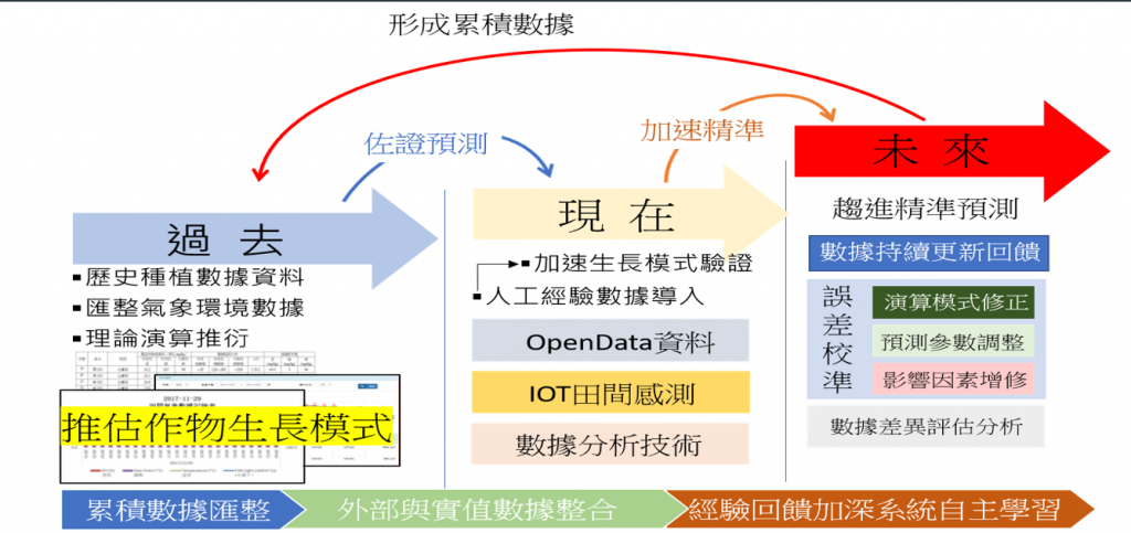
The agriculture industry in Taiwan Lettuce Village currently only implements "information management." Even though it has the concept of data application, there are no implementation methods and direction, and fields are still manually inspected and the dosage of pesticides is determined based on experience. Since crop production varies due to environmental factors each season, the accumulated temperature conditions required for lettuce growth can be estimated by comparing crop yield and harvest date based on historical meteorological data, thereby establishing an accumulated temperature calculation module to estimate the cultivation schedule, allows the system to automatically analyze and make prediction based on the current temperature and humidity of the overall environment. During the crop harvesting period, it assists field personnel in optimizing their work, reducing the need for daily inspections to determine when to schedule the next task.

Agricultural information system + AI allows lettuce to grow smoothly

"The stability of the cultivation environment" plays an important role in the growth process of crops. Understanding the growing conditions of crops can greatly increase production and maintain a certain level of quality. Combined with "smart equipment in the field" and "linebot," field management can be carried out and warnings can be received at any time, allowing managers to respond quickly to reduce potential losses, and assist in disease prevention, growth period, and harvest prediction. It can be further integrated with data from the Central Weather Administration to establish a "cultivation database," and conduct agricultural analysis through data collection, such as: fertilizer dosage planning, analysis of lettuce growth days in different months, analysis of the quality and weight of lettuce output based on temperature, and even disease prevention predictions.

Comparison of differences before and after digitization

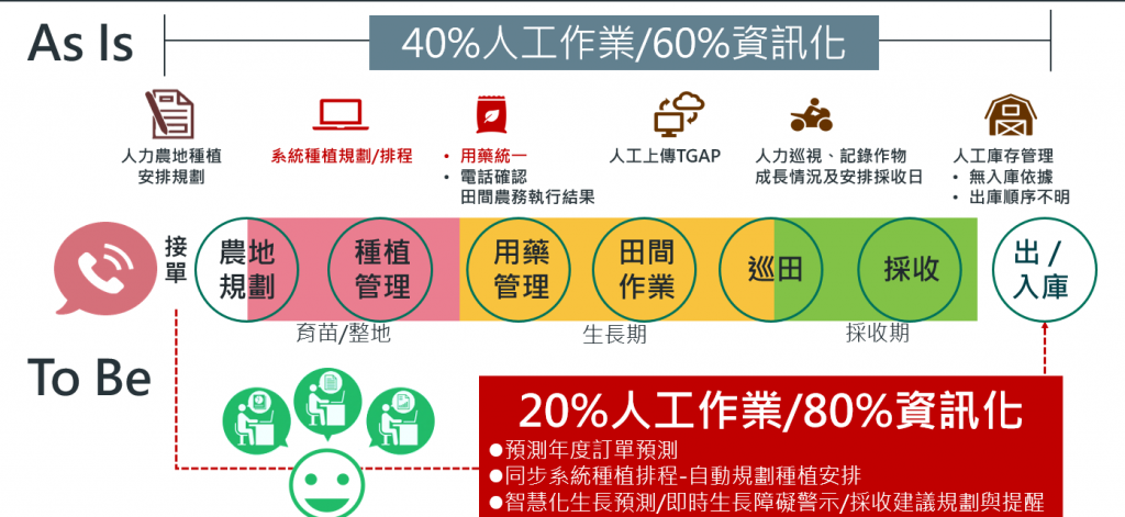
▲ Comparison of differences before and after digitization

Compiled the cultivation data collected by the Lettuce Village from field equipment and external data , such as: temperature, humidity, sunlight, and farmland fertility, and applied the data in four aspects, including:

1. establishing crop progress and growth obstacle information, analyzing the temperature ranges that are suitable for growth and hinder growth, importing open data (real-time and future weather forecast data) to establish forecast standards, and using weather sensing equipment for field monitoring, in order to achieve real-time warning notifications and preventive effects.

2. Utilize cultivation data for growth predictions, in order to achieve the goal of estimating harvest date.

3. Using mobile phones for weather monitoring achieves the goal of real-time control and adjustment of field operations, allowing Lettuce Village to effectively manage manpower, material costs, and crop quality.

4. Compiled farmland fertility data to provide the fertilizer ratios for suitable for farmland and reduce the frequency of fertilization, improving farmland fertility while improving the overall environment.

Description of Data Applications

▲ Description of Data Applications

The system will continue to be optimized and promoted it to more units

The "Intelligent Agriculture Big Data Application Platform" allows farmers in Lettuce Village to no longer be limited to the traditional agricultural business model, achieve systematic cultivation and production management, and standardize specifications to improve quality, stabilize output, and reduce labor consumption and material costs.

Improved pest and disease detection accuracy from 80% to 100%

In the future, we hope to increase the accuracy of pest and disease detection, so that farmers can monitor the status of crops in real time, making the system more complete. We also hope to apply this system model to more crops, and allow more farmers to consistently grow high-quality crops at low cost through government promotion.

Recommend Cases

【解決方案】連聯合國都買單 悠由數據應用運用農業數據搶攻全球商機
Even the United Nations is on board! Yoyo Data Application captures global business opportunities with agricultural data

Nearly 2,000 days in the fields have made Yoyo Data Application a top player in Taiwan’s agricultural data sector Their comprehensive grasp of crop yields, production periods, and prices has enabled them to collaborate with the United Nations The service area for agricultural land skyrocketed from 24 hectares to over 6,000 hectares in less than three years—a 250-fold increase For Wu Junxiao, founder and CEO of Yoyo Data Application, aligning with global environmental trends and becoming a data company at the intersection of climate technology and the green economy to serve the global market is his ultimate entrepreneurial goal Wu Junxiao, originally an engineer, joined the Industrial Technology Research Institute in 2010, where he honed his profound technical and data science analytic skills 'At that time, I was working in data analysis engineering, and almost all data-related materials would be directed to me Additionally, I worked on indoor cultivation boxes, planting vegetables and mushrooms, hence planting the seed of entrepreneurship by integrating agriculture with data analysis,' Wu recalls Since 2016, Wu Junxiao has been frequently visiting farms to 'embed' himself among farmers and agricultural researchers, chatting and sharing information systematically, which quickly established his agricultural know-how Solid data analysis capabilities have even convinced the United Nations In 2017, he left the Institute to start his own business and founded Yoyo Data Application in 2019 Today, many agricultural businesses are his clients, with service areas rapidly climbing from 24 hectares to over 6,000 hectares, expected to surpass 7,000 hectares in 2022 His clientele includes markets in Japan, Central America, and even entities under the United Nations like the World Farmers Organization, which utilizes the 'Yoyo Crop Algorithm System' supported by Yoyo Data How exactly does Yoyo Data Application manage to impress even UN agencies The 'Yoyo Crop Algorithm System' developed by Yoyo Data Application accurately predicts the production period, yield, and prices Firstly, due to Wu Junxiao's precise mastery over agricultural data, Yoyo Data Application's clients don't necessarily need sensors or other hardware devices 'Sensors are expensive and if you buy cheap devices, you just collect a lot of noise or flawed data, which is useless,' Wu explains He continues, 'Collecting data doesn't necessarily require sensors our data solutions can solve problems more directly and effectively' For instance, one of Yoyo Data Application's products, the Yoyo Money Report Agri-price Linebot, developed in collaboration with LINE in 2020, gathers data on origin, wholesale, and terminal prices spanning over 10 years, driven by Yoyo Data’s proprietary AI algorithms This enables the system to autonomously learn about agricultural product trading prices, using big data and AI to perform price prediction analysis, thereby helping buyers reduce transaction risks and expanding the data application to the entire agricultural supply chain Regarding banana prices, the accuracy of price predictions increased from the original 70 to 998 Wu Junxiao notes that both buyers and farmers are very sensitive to prices Now, through the Yoyo Money Report service, both buyers and farmers can precisely understand the fluctuations in agricultural product prices Yoyo Data can also provide customers with optimal decision-making advice based on predictive models for crop growth, yield, and price estimations Currently, price predictions cover 28 types of crops Precise estimates of production periods and price fluctuations allow Yoyo Data to provide differentiated services based on data analysis The 'Yoyo Crop Algorithm System' provided by Yoyo Data Application incorporates a 'Parameter Bank', usually collecting 200-300 parameters, not just straightforward data like temperature and humidity, but also data divided according to the physiological characteristics of the crops Through effective dynamic data algorithms, it can accurately calculate when crops will flower and when they can be harvested, what the yield will be, and so forth For instance, the prediction accuracy of the broccoli production period is 0-4 days, with the flowering period predicted this year to be precisely 0 days, perfectly matching the actual flowering time in the field In these dynamic calculations, a 7-day range is considered reasonable, and the average error value of Yoyo Data's predictions typically ranges from 2-4 days, with most crop production period accuracies above 80 Through effective dynamic data algorithms, over 120 global crops can have their production periods and yields accurately estimated Using these effective dynamic data algorithms can set estimates for production quantities, helping adjust at the production end Yoyo Data Application's clientele primarily includes exporters of fruit crops like pineapples, bananas, guavas, mangos, pomelos, sugar apples, Taiwan's agricultural production is highly homogenized, often leading to a rush to plant the same crops and resulting in price crashes Yoyo Data Application helps clients differentiate their offerings Thus, Wu Junxiao positions his company as a boutique digital consultant, carefully selecting clients for quality over quantity He notes that Taiwanese agricultural clients focus on how to improve yield rates, even categorizing yield rates by quality, aiming for high-quality, specialized export markets whereas international clients prioritize maximizing per-unit yields, showing different operational approaches in domestic and international markets In addition to agricultural fruit, Yoyo Data Application has also extended its services to the fisheries sector, including species like milkfish, sea bass, and white shrimp, all using the same system to establish various parameters related to the growth of fish and shrimp, such as when to feed and when to harvest, and the anticipated yield, timing, and prices Yoyo Data Application harnesses the power of data to create miracles in smart agriculture In response to the company's rapid development, Yoyo Data Application introduced venture capital funds in 2021 to expand its staff and promote its business Wu Junxiao states that in response to the global trend towards net zero carbon emissions by 2050, he plans to help clients plant carbon in the soil, effectively retaining carbon in the land while also connecting clients to carbon trading platforms, creating environmental business opportunities together Wu Junxiao says that from the start of his entrepreneurial journey, he positioned the company as a global entity, thus continuous international collaborations are planned As a data company serving a global clientele and focused on climate technology and the green economy, this represents Wu’s expectations for himself and his company's long-term goals Yoyo Data Application founder and CEO Wu Junxiao「Translated content is generated by ChatGPT and is for reference only Translation date:2024-05-19」

這是一張圖片。 This is a picture.
AI Assists the Red Cross for Smarter Emergency Response

More Preparation Less Loss The Taiwan Food Bank Association, a non-profit organization, collects donations daily from wholesalers, retailers, manufacturers, and even kind-hearted individuals across Taiwan They also rescue consumable materials that are about to be discarded, properly allocate and deliver to households in need, aiding local underprivileged populations When natural disasters such as earthquakes, landslides, mudslides, typhoons, floods, and droughts occur in Taiwan, the food bank's resources can be immediately deployed for disaster relief This field verification unit is the Nantou County Red Cross AssociationOne of the food bank locations, hereinafter referred to as the Nantou Red CrossIs responsible for tasks like pre-disaster supplies preparation and disaster relief material distribution, helping the government bear the responsibility of disaster relief and aid In Taiwan, various natural disasters have characteristics of different duration and spatial coverage, wide or narrow With the normalization of extreme weather, the scale and number of disasters are gradually increasing and becoming harder to predict The required amount and type of materials differ by disaster, and they must address the lifestyles of the affected areas, rescue needs, traffic conditions, geographical restrictions, and other factors for varied material allocation, facing numerous challenges Typhoon Kanu severely damaged transportation in Nantou mountain areas Nantou County Red Cross planned the mountainous route Puli gt Fazhi Elementary School gt Qin'ai Village gt Aowanda to deliver supplies Disasters happen repeatedly We need to be prepared at all times Effective disaster preparedness can mitigate the impact, including swift response to material needs in affected areas, aid distribution, and even psychological support, providing added security for life and property of those in disaster zones Lack of Timeliness in Disaster Information To improve the living conditions and address the lack of supplies in remote areas, the Taiwan Food Bank Association has partnered with the Nantou Red Cross and has successively established food bank points in Nantou City, Puli, and Ren'aiLixing, Ruiyan, XinyiWangmei, Tongfu, Shuili, Lugu and Caotun among others9establish food bank locations, providing supplies worth a certain amount per household every month6001000in New Taiwan Dollars However, many challenges still need to be overcome during natural disasters For example, when typhoons, earthquakes, and landslides occur, the information source for disaster relief dispatch systems relies on post-disaster reports The time lag between reporting, response, and execution prevents timely adjustment and distribution of 'disaster relief' supplies based on the needs of affected areas, affecting rescue efficiency due to lack of timely information The 'preparedness' supplies of the Nantou Red Crosssuch as dry food, water, instant noodles, etc,are recorded manually in terms of stock, expiration dates, and distribution,When a disaster occurs, there is a chance that 'preparedness' supplies have expired and cannot become 'disaster relief' supplies It’s also possible that both conditions mentioned above occur simultaneously, leading to a need for more time to reassign 'preparedness' supplies into usable 'disaster relief' materials On the other hand, upon receiving information about shortages in disaster areas, the supplies donated by the public often grossly differ from the actual needs of the disaster zone, leading to an excess of supplies The Process of Material Operations Before and After a Natural Disaster AIAnticipating Natural Disasters Reinforcing the Accuracy of Preparedness Material Dispatch Application API Technology connects to compute the state of the climate, the intensity of disaster rescues, prioritizing the main tasks of the Nantou Red Cross and the needed areas of search and rescue Coordinated with the existing heavy rain and typhoon simulation disaster training of the Nantou Red Cross, a 'Natural Disaster Emergency Preparedness Material Dispatch and Supplement Decision System' is establishedreferred to as the Emergency Preparedness Material System。 In material management, inventory data along with immediate supply data are entered into the Emergency Preparedness Material System for comparison and analysis, helping the Nantou Red Cross quickly recognize materials like cookiesdry food, beverages, frozen food, toilet paper, etc, and determining whether they should be 'preparedness' materials or regularly distributed materials Adding to this, information forecasting understands the potential disaster conditions in remote areas, facilitating food delivery, addressing both front-end food wastage and backend practical needs When a natural disaster occurs, it enables faster response and decision-making, completing material deployment, hence increasing the speed of material operation transition20。 AI Emergency Preparedness Material System Helps Rapidly Adapt Material Distribution Through the field verification of the Nantou Red CrossAIthe system, material management, and related applications are promoted to more emergency response organizations in different areas, while continuously improving the alert functions within the Emergency Preparedness Material System, strengthening the technological foundation for alerts, enhancing prediction accuracySystem immediacy, and optimizing the data collection and analysis process Simultaneously, it can collaborate with government agencies, meteorological departments, or other rescue teams to discuss integrating more data sources, establishing a mechanism to share resources and data promptly, sharing information in real-time, helping more emergency response organizations enhance their disaster response abilities, seizing the golden rescue time 「Translated content is generated by ChatGPT and is for reference only Translation date:2024-12-12」

【導入案例】巨量遙測空間數據AI分析雲端服務平台 使衛星遙測影像順利落地應用
AI Analysis Cloud Service Platform for Remote Sensing Big Data Enables the Smooth Application of Satellite Remote Sensing Images

Although satellite remote sensing images can make all surface objects visible, it still requires a lot of time and manpower to be truly applied to the industry In order to effectively solve the problems that customers face in digesting huge amounts of image data and eliminate technical obstacles for cross-domain users to process satellite remote sensing images, ThinkTron has developed an "AI Analysis Cloud Service Platform for Remote Sensing Big Data" as a new beginning for cross-domain AI applications for spatial information In recent years, in response to the impact of industrial globalization, Taiwan's agriculture has continued to transition towards technology-based and higher quality, improving the yield and quality of crops by solving problems, such as microclimate impacts and pest and disease control The demand of agriculture on images has expanded endlessly to accurately grasp the growing environment of crops In the early years when UAVs unmanned aerial vehicles were not yet popular, manual field surveys were the most basic but most labor-intensive work With the emergence of UAV drones, aerial photography operations might not be difficult, but the range that can be photographed is limited Furthermore, surveying expertise is required to accurately capture spatial information At this time, the use of satellite remote sensing data may break away from the past imagination of using image data Taiwan Space Agency TASA ODC data warehouse services In the past ten years, with the breakthrough of modern satellite remote sensing application technology, Digital Earth has become a new trend in global data collection Countries have developed data cube image storage technology, and the development of smart agriculture has become one of the largest image users Determining planting distribution is the first step in understanding crop yields Free satellite remote sensing images, powerful data warehousing support, and the team's robust image recognition technology are important supports for accelerating agricultural transformation Using satellite remote sensing image data can accelerate the development of smart agriculture However, in the past, it was difficult to extract large-area crop distribution through satellite remote sensing images, not to mention the cost If you wanted to use free information, you had to visit all websites of international space agencies, look through the wide variety of satellite specifications, and carefully evaluate the sensor specifications, image resolution, and revisit cycle After finding suitable images, you had to look at them one by one to filter the ones you need Next is downloading dozens of images that are often several hundreds of Megabytes MB each, which might exceed the capacity of your computer Also, after overcoming image access and preparing data, you must then start to confirm the downloaded image products and which bands you want, because the image you see is not just an image file jpg or png, but rather complex multi-spectral information, attribute fields and coordinate information It takes a lot of effort just to confirm the correct information Facing GIS software packages with complex functions is the start of another trouble The complex image pre-processing process and the inflexible machine learning package greatly reduce the efficiency of analyzing data After finally getting the results of crop identification, you might find that the best time for using map information may have already passed The above-mentioned complex and time-consuming satellite image processing problems are precisely the pain points of the market ThinkTron expanded from traditional machine learning to modern deep learning applications, and developed an "AI Analysis Cloud Service Platform for Remote Sensing Big Data" under the GeoAI framework, breaking through the constraints of details in the spatial information for customers Differences between the process before and after introducing the AI analysis cloud service platform ThinkTron said that Taiwan's ODC Open Data Cube system has been completed and began providing services after years of efforts from the Taiwan Space Agency TASA, formally becoming aligned with international trends The powerful warehousing technology allows users to easily capture and use image data of a specific time and spatial range according to their needs The warehouse stores multiple satellite image resources from international space agencies, including the ESA's Sentinel-1 one image every 6 days, Sentinel-2 one image every 6 days, USGS's Landsat-7 one image every 16 days, Landsat-8 one image every 16 days, and the domestic Formosat-2 one image every day and Formosat-5 one image every 2 days ThinkTron develops satellite image recognition tools based on Python Breaking free from the limitations of GIS Geographic Information System software packages, ThinkTron integrated GDAL Geospatial Data Abstraction Library based on Python, and considered computing efficiency and parallel processing when developing all tools required for satellite image processing and image recognition modeling, including coordinate system and data format conversion, grid and vector data interaction, and data intra-difference and normalization All of the tools are designed with AI applications in mind, and some commonly used tools are packaged into an open source package under the name TronGisPy to benefit the technical community ThinkTron utilized the team's understanding of satellite remote sensing images and the collected tagged data crop distribution maps to preset the image recognition modeling process, the required training data specifications, and dataset definitions This is imported into the machine learning LightGBM or deep learning CNN framework that was completed in advance, and the entire training process to be performed in the Web GIS interface, providing users with partial flexibility to freely filter images, confirm spatial and temporal ranges, select models, and adjust hyperparameters In addition to the operation of training models, it also provides historical models to output identification results, and finally displays the identification results of crop distribution on the Web GIS map In fact, agriculture is not the only industry that needs satellite remote sensing applications AI applications of spatial information have also appeared in various fields as companies in different industries aim to enhance their global competitiveness For example, surveying and mapping companies that have a large amount of map data can use the AI analysis cloud service platform to store map data while also accelerating the efficiency of digital mapping Under the severe global climate change and the risk of strong earthquakes, there is a wide variety industrial insurance, agricultural insurance, financial insurance, or disaster insurance are all inseparable from spatial information The use of remote sensing image recognition to understand insurance targets has long been an international trend AI Analysis Cloud Service Architecture for Remote Sensing Big Data