:::

【2020 Application Example】 AI-Enhanced 'Banana Contract Cooperation Management System', Effectively Increasing Banana Export Value!

Banana industry faces low-priced impacts from abroad

In recent years, our country's banana industry has been impacted by low prices from the Philippines and Ecuador, with sales volumes decreasing annually, no longer seeing the golden era of Taiwan's banana exports to Japan.

The structure of banana pricing at the green stage doesn't vary much internationally, with similar inputs of fertilizers and harvested weights among countries. However, international banana pricing for a box from the Philippines is around 11 USD, whereas Taiwanese bananas cost around 22 USD per box. This is primarily due to the efficiency of investment capital and output at the 'collection centers' post-harvest. The fragmented and scattered local farmlands substantially increase the costs of final products and thus restrict the export dynamics.

Furthermore, climate change affects the traditional southern export regions for Taiwanese bananas. Warmer winters and altered summer rainfall patterns affect the physiognomies of the bananas produced, causing their size to rapidly exceed export standards and increasing the cost per unit of qualified goods during collection center processing; or excessive water content which depreciates the taste historically associated with them, leading to a decrease in market prices. These pressures from rising costs and dropping prices further squeeze the commercial value and viability of Taiwanese bananas.

Differences in planting environment affecting the stability of banana quality for export

A fruit and vegetable cooperative in Yunlin County, originally a domestic banana collection center located in Yunlin, wasn't historically a part of Taiwan's banana export regions. Since a field survey conducted in 2017 by TaiNong Co., Ltd., it was discovered that the quality of bananas produced in Yunlin has been comparatively stable against those from the southern regions. The tighter organization of local farmers and crop rotation practices between rice and banana farms helped reduce incidences of Yellow Leaf Disease and effectively maintain production levels.

Banana export

▲ Banana export

However, without prior experience in exports, TaiNong gradually introduced Japanese standards for exporting with the local farmers, defining the size and width of fruit fingers, stalk cutting, and boxing methods. This aims to gradually establish a banana export hub in the central region. Yet, the climate in Yunlin significantly differs from the southern regions. Current practices in banana exporting are based on experiences from Kaohsiung and Pingtung and do not incorporate how the shift in production areas northwards affects banana growth. Hence, there remain excessive rejections at the collection centers occasionally causing disputes among farmers.

Agricultural risk management data service, development of banana specification volume fluctuation prediction model

台農發股份有限公司既有之集貨場對契作香蕉農戶包裝分類品檢機制,收集之數據資料與悠由數據應用股份有限公司配合,運用資料科學研究方法,透過研究規劃、資料蒐集擷取、資料清洗、特徵萃取、資料融合、資料分析演算法建立、分析結果、模板開發、專家會議討論等步驟建立分析應用流程。

By integrating dataset including collection centers' incoming batch container numbers, origin, banana quantities, data on each box of fruit bunches, and data of defect sampling records, along with internal purchase prices and prices from various purchasers, through the Banana Contract Cooperation Management System linked with data decision analysis systems and APIs, it supports subsequent judgments by providing analysis data to the fruit and vegetable production cooperative.

悠由數據擷取與蒐集香蕉契作戶產地之歷年氣象環境資料、公開批發市場的產地價格及香蕉生理模式等數據,結合台農發的分類品規數據,建立「香蕉品規量能波動預測」演算機制,並將分析預測結果回饋至香蕉契約合作作業管理機制。

Visualized harvest scheduling analysis

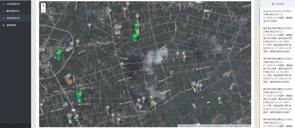
▲ Visualized harvest scheduling analysis

By leveraging varied predictive analytic outcomes of banana specifications, collection centers can utilize this as an advance warning and risk management decision-making tool, further adjusting supply to tackle inconsistent production capacity and specifications faced during acquisition.

Fruit and vegetable cooperative X TaiNong X Youyou Data Applications collaborating closely, creating a win-win-win!

This successful alliance formed a close cooperative relationship between the place of production, TaiNong, and Youyou Data. Previously, farmers often distrusted traders, and traders lacked control over farmers, leading to conflicts. This alliance allows the requirements of the distribution side to reflect actual shipment specification fluctuations and present them digitally, enabling farmers to objectively understand their shipping quality and empathize with the difficulties of traders, thus fostering cooperation.

Innovative model of banana contract management

TaiNong's cooperation with Youyou Data on the banana contract management system provides a platform that combines crop physiology with climate predictions to obtain foresight data. For other products managed by TaiNong, such as pineapples, lettuce, carrots, and pineapple sugar apples, this has been greatly enlightening.

In the future, by facilitating farmers to participate in the Production History System and connecting land registry data with this contract system, the introduction of the Production History System will be aided. This system is also considered by TaiNong for commercial acquisition moving forward.

「Translated content is generated by ChatGPT and is for reference only. Translation date:2024-05-19」

Recommend Cases

這是一張圖片。 This is a picture.
Using Plant Growth Chambers as an Example - Standardizing Electronic Device Procedures Based on Imaging

In recent years, global climate change and environmental issues have become increasingly severe, causing major impacts on agricultural production Traditional agriculture heavily relies on weather conditions, facing challenges such as unstable crop quality, plummeting yields, and difficult pest control Particularly in Taiwan, agricultural biotech companies and farmers have suffered continuous losses, creating an urgent need for innovative solutions Meanwhile, Taiwan's plant factory industry faces many challenges high equipment and labor costs, an incomplete industrial chain diminishing international competitiveness, and a lack of cooperation among enterprises, all of which limit industry development Additionally, COVID-19the pandemic has highlighted the importance of remote monitoring and management Traditional manual inspections and data collection methods no longer meet the needs of modern agricultural production These issues collectively underline the urgent need for smart agricultural solutions, driving companies like Taiwan's HaiBoTe to develop innovative projects integrating IoT, cloud computing, and artificial intelligence technologies HaiBoTe Cloud Data Integration and Analysis Platform Facing these challenges, the agricultural sector urgently needs a system that can precisely control growth environments, improve resource efficiency, enable remote monitoring, and facilitate intelligent management Existing plant factory equipment often requires complete replacement, with poor compatibility with older equipment, and sensors and camera systems may require different interfaces, making them inconvenient to use Therefore, there is a need for a flexible solution that can integrate various equipment and technologies, providing real-time monitoring and data analysis, and automatically adjusting environmental parameters based on plant growth conditions This demand exists not only in Taiwan but is also a global trend in the development of smart agriculture By incorporating artificial intelligence, more scientific evaluation standards can be established, optimizing production processes, improving yield and quality, while reducing energy consumption and environmental impact Additionally, such smart solutions can attract more young people to participate in agricultural production, promoting industry upgrading and sustainable development Overall, the demand for smart agricultural solutions stems from the urgent requirements to address climate change, enhance production efficiency, reduce costs, and achieve precise management, and this is exactly the problem companies like Taiwan's HaiBoTe are striving to solve Taiwan's plant factory operators are facing a series of severe challenges, which are gradually eroding their competitiveness and survival space Firstly, the high cost of equipment and operations is their biggest burden Each electricity bill feels like a heavy blow, forcing them to balance between ensuring product quality and controlling costs Secondly, the unpredictability brought by climate change has become their nightmare Sudden extreme weather events can destroy their carefully nurtured crops in a short time, causing massive economic losses What's worse, they find themselves increasingly at a disadvantage in international market competition In contrast, large overseas plant factories, with their advanced automation technology and well-organized supply chains, can produce stable-quality agricultural products at lower costs, putting unprecedented pressure on Taiwan's operators On the technical level, they also face numerous challenges Compatibility issues between new and old equipment often put them in a bind, encountering various technical obstacles when trying to integrate different systems Lack of precise data analysis and forecasting capabilities also makes it difficult for them to make production decisions and accurately determine the best growth conditions for each crop Existing monitoring systems provide data that is often disorganized, difficult to interpret and apply Human resource challenges are also severe, with young people generally lacking interest in agricultural work, making it difficult for them to recruit employees with modern agricultural skills Even existing employees often feel exhausted from tedious manual operations and monitoring tasks These problems are intertwined, creating a complex dilemma that leaves plant factory operators confused and anxious They urgently need a comprehensive solution that can enhance factory operational efficiency, reduce costs, and improve product competitiveness, helping them overcome difficulties and regain their footing in the fierce market competition In facing the various challenges of plant factory operators, Taiwan's HaiBoTe company has demonstrated exceptional technical innovation and a flexible customer-oriented development strategy They deeply understand that the solution must be able to seamlessly integrate existing equipment while providing highly intelligent management functions To this end, HaiBoTe's RD team adopted a modular design approach to develop a system that can be flexibly configuredIoTIoT system The core of this system is a smart control hub that can communicate with various sensors and actuators During development, HaiBoTe worked closely with customers, deeply understanding their specific needs and operational environments They even dispatched engineers onsite to observe the daily operations of the plant factories, ensuring that the developed system actually solves practical problems This in-depth cooperation not only helped HaiBoTe optimize their product design but also established a close relationship with customers, laying the foundation for subsequent continuous improvements HaiBoTe's innovation is not just reflected in hardware design but also in their developed intelligent software system This system integrates advanced machine learning algorithms, capable of precise forecasts and optimal control of plant growth conditions based on large amounts of historical data and real-time monitoring information To help customers overcome technical barriers, HaiBoTe designed an intuitive and easy-to-use user interface, which even non-technical operators can master easily Additionally, they provide comprehensive training and tech support services, ensuring customers can fully utilize all functions of the system When facing challenges, HaiBoTe's technical team can quickly identify problems through remote diagnostics and provide solutions In one incident, during a serious equipment failure emergency faced by a customer, HaiBoTe's engineers guided the customer through system remote access, successfully instructing them on repairs and avoiding potential massive losses This full-range service not only solves customers' immediate difficulties but also strengthens their confidence in intelligent management, driving the entire industry toward more efficient and sustainable development HaiBoTe's developed smart agriculture solution not only brought revolutionary changes to plant factories but also painted an encouraging picture for the future of the entire agricultural industry The excellence of this system is evident in several aspects firstly, it achieves precise control of the plant growth environment, significantly improving crop yield and quality stability Through advanced artificial intelligence algorithms, the system can forecast and adjust optimum growth conditions based on historical data and real-time monitoring information, ensuring each plant grows in the ideal environment Secondly, it significantly reduces energy consumption and operational costs, improving resource efficiency The intelligent management system optimizes water, electricity, and nutrient supply, reducing waste and lowering manpower costs Additionally, the system's modular design and strong compatibility allow it to seamlessly integrate various new and old equipment, providing a flexible solution for gradual upgrades of plant factories Most importantly, the system injects a sense of technology and modernity into agricultural production, helping to attract the younger generation to the field and injecting new vitality into the industry Looking ahead, HaiBoTe's smart agriculture system has broad application prospects and expansion potential In addition to plant factories, this system can also be applied to traditional greenhouse cultivation, urban agriculture, and even home gardening In the field of aquaculture, similar technology can be used to monitor and optimize the breeding environments for fish or shrimp In the food processing industry, similar intelligent monitoring and forecasting systems can be used to optimize production processes and enhance food safety Even in the pharmaceutical industry, this type of precise environmental management system could be applied to drug research and production processes To further promote this system, HaiBoTe could adopt a multifaceted strategy Firstly, they could collaborate with agricultural colleges and research institutions to establish demonstration bases, allowing more people to experience the benefits of smart agriculture firsthand Secondly, they could develop customized solutions tailored to different scales and types of agricultural production, expanding the applicability of their products Furthermore, they could raise awareness and acceptance of smart agriculture within the industry by hosting forums, online seminars, and sharing success stories Lastly, they could explore collaborations with government departments to integrate this system into policies supporting the modernization and sustainable development of agriculture, thereby promoting the widespread adoption of smart agriculture on a larger scale Through these efforts, HaiBoTe not only can expand its market share but also make a significant contribution to the sustainable development of global agriculture, truly realizing the vision of technology empowering agriculture 「Translated content is generated by ChatGPT and is for reference only Translation date:2024-12-09」

這是一張圖片。 This is a picture.
CCTV Intelligent Video Search System

Search for a specific person, find someone with a suitcase entering the factory in Gao'an area Color features of the person and the object confirmed, person in blue and black top, suitcase in black color, throughCCTV the intelligent video search system, by setting object and color retrieval conditions, it can successfully locate three video clips containing the target subject This greatly aids operational staff in finding the target items, and through this system, search speed can far surpass manual effort6fold Pain Points The CSE-Kaohsiung Plant is densely equippedCCTVto monitor every corner of the plant area, but when an incidenthappens, it's impossible within a limited time throughCCTVvideo playback to find the incident, the implications and risks behind this are self-evident Many areas that are usually unmanned can easily become security blind spots Thus, how to monitor a vast plant area more intelligently and effectively is one of the crucial aspects of building a smart plant for the semiconductor industry The AES Plant in Kaohsiung covers a vast area, with many important sites requiring monitoring of personnel movements to ensure corporate secrets and employee safety 1 Automated production lines and warehouses In semiconductor enterprises’ automated production lines and warehouses, oftenAGV(Automated Guided VehicleAGVs automated guided vehicles travel at high speeds if plant personnel inadvertently enterAGVthe moving area and cannot issue a warning to the person, then the regrettable accidents that occur will be too late to reverse 2 Material and product storage areas Materials used in semiconductor-related processes are costly if areas storing materials or products are breached, there is a risk of loss of high-value materialsproducts 3 High-security areas Trade secrets relate to the core technological competitiveness of semiconductor-related enterprises if someone breaches the high-security areas, there is a risk of corporate secrets being leaked The safety of trade secrets has always been one of the most critical issues for semiconductor enterprises 4 Loading docks At AESLButthe dock area often has loading vehicles coming and going if someone intrudes into the dock area, there is a risk of vehicle collisions and accidents Additionally, goods awaiting shipment at the dock area could be stolen or potentially damaged from collisions, thus causing significant reputation and financial losses for the company, further leading to production and shipping inconvenience When an abnormal event occurs, how to quickly search for the relevant key footage from massive data Many important locations within the AES Kaohsiung Plant need to be equippedCCTVfor safety checks, butCCTVWith thousands to tens of thousands of cameras, manually searching through footage for an event requires laborious frame-by-frame review which is time-consuming and inefficient In light of advancements in computer vision, it's beneficial to utilizeAIto replace manual playback and searching Problem Scenario Object Detection The data source for object detection comprises two parts Open-source datasetsOIDv4and AES Kaohsiung PlantCCTVImage files For these files, search for usable data, specificallyOIDv4image files For these files, extract the defined nine major categories of objects for training data among them, two object categories, knives and gasoline barrels, were not found inOIDv4found usable data for knives and gasoline barrels, while the remaining seven categories of objects are available fromOIDv4useful training data found for the remaining seven categories of objects, all marked Regarding the Kaohsiung PlantCCTVimage files, select some frames Frame of the footage, and manually annotate the objects to be_detected for training and testing data Nine Major Objects Color Recognition The data source for color recognition is divided into two partsInternet image screenshots, and Kaohsiung PlantCCTVimage files Currently, no publicly available open-source datasets specifically for color recognition applications have been found, so images are collected from the web Search the web for images of the defined nine major object categories, save the images after separating the objects from the background, keeping only the object sections, and mark the images according to color Additionally, for the Kaohsiung PlantCCTVimage files, use the already-markedbounding boxextractCCTVimage files from variousFramesections of objects identified by color, and finally, visually identifiable images are marked according to color Each object category has its specific color definition, depending on the usual colors seen in these objects in real life Dynamic Ignore during Training FromOIDv4during the training of the object detection pilot model, since each image in this dataset is only marked for a single category, but the image may contain other desired detection categories unmarked For such cases, dynamic ignore techniques will be employed during training to avoid confusion Next, use the extracted training data from the Kaohsiung Plant toFine-Tuneenhance the detection rate of the object in specific designated areas Finally, select the model that computes the lowest loss value in the test set during the training process as the main object_detection model Dynamic Ignoring AIHelp You View CCTV The intelligent video search system primarily serves as an assistive system for searching surveillance footage, capable of speeding up the process of finding target events by setting search conditions for objects By simply defining the search conditions, you can quickly produce thumbnails of critical objects and playback for review, shortening the time required for manual case retrieval of the past The search time is quickly6doubled, allowing the front-end security unit to use this platform to strengthen the first line of risk management supervision and take timely preventive measures 「Translated content is generated by ChatGPT and is for reference only Translation date:2024-12-12」

【導入案例】巨量遙測空間數據AI分析雲端服務平台 使衛星遙測影像順利落地應用
AI Analysis Cloud Service Platform for Remote Sensing Big Data Enables the Smooth Application of Satellite Remote Sensing Images

Although satellite remote sensing images can make all surface objects visible, it still requires a lot of time and manpower to be truly applied to the industry In order to effectively solve the problems that customers face in digesting huge amounts of image data and eliminate technical obstacles for cross-domain users to process satellite remote sensing images, ThinkTron has developed an "AI Analysis Cloud Service Platform for Remote Sensing Big Data" as a new beginning for cross-domain AI applications for spatial information In recent years, in response to the impact of industrial globalization, Taiwan's agriculture has continued to transition towards technology-based and higher quality, improving the yield and quality of crops by solving problems, such as microclimate impacts and pest and disease control The demand of agriculture on images has expanded endlessly to accurately grasp the growing environment of crops In the early years when UAVs unmanned aerial vehicles were not yet popular, manual field surveys were the most basic but most labor-intensive work With the emergence of UAV drones, aerial photography operations might not be difficult, but the range that can be photographed is limited Furthermore, surveying expertise is required to accurately capture spatial information At this time, the use of satellite remote sensing data may break away from the past imagination of using image data Taiwan Space Agency TASA ODC data warehouse services In the past ten years, with the breakthrough of modern satellite remote sensing application technology, Digital Earth has become a new trend in global data collection Countries have developed data cube image storage technology, and the development of smart agriculture has become one of the largest image users Determining planting distribution is the first step in understanding crop yields Free satellite remote sensing images, powerful data warehousing support, and the team's robust image recognition technology are important supports for accelerating agricultural transformation Using satellite remote sensing image data can accelerate the development of smart agriculture However, in the past, it was difficult to extract large-area crop distribution through satellite remote sensing images, not to mention the cost If you wanted to use free information, you had to visit all websites of international space agencies, look through the wide variety of satellite specifications, and carefully evaluate the sensor specifications, image resolution, and revisit cycle After finding suitable images, you had to look at them one by one to filter the ones you need Next is downloading dozens of images that are often several hundreds of Megabytes MB each, which might exceed the capacity of your computer Also, after overcoming image access and preparing data, you must then start to confirm the downloaded image products and which bands you want, because the image you see is not just an image file jpg or png, but rather complex multi-spectral information, attribute fields and coordinate information It takes a lot of effort just to confirm the correct information Facing GIS software packages with complex functions is the start of another trouble The complex image pre-processing process and the inflexible machine learning package greatly reduce the efficiency of analyzing data After finally getting the results of crop identification, you might find that the best time for using map information may have already passed The above-mentioned complex and time-consuming satellite image processing problems are precisely the pain points of the market ThinkTron expanded from traditional machine learning to modern deep learning applications, and developed an "AI Analysis Cloud Service Platform for Remote Sensing Big Data" under the GeoAI framework, breaking through the constraints of details in the spatial information for customers Differences between the process before and after introducing the AI analysis cloud service platform ThinkTron said that Taiwan's ODC Open Data Cube system has been completed and began providing services after years of efforts from the Taiwan Space Agency TASA, formally becoming aligned with international trends The powerful warehousing technology allows users to easily capture and use image data of a specific time and spatial range according to their needs The warehouse stores multiple satellite image resources from international space agencies, including the ESA's Sentinel-1 one image every 6 days, Sentinel-2 one image every 6 days, USGS's Landsat-7 one image every 16 days, Landsat-8 one image every 16 days, and the domestic Formosat-2 one image every day and Formosat-5 one image every 2 days ThinkTron develops satellite image recognition tools based on Python Breaking free from the limitations of GIS Geographic Information System software packages, ThinkTron integrated GDAL Geospatial Data Abstraction Library based on Python, and considered computing efficiency and parallel processing when developing all tools required for satellite image processing and image recognition modeling, including coordinate system and data format conversion, grid and vector data interaction, and data intra-difference and normalization All of the tools are designed with AI applications in mind, and some commonly used tools are packaged into an open source package under the name TronGisPy to benefit the technical community ThinkTron utilized the team's understanding of satellite remote sensing images and the collected tagged data crop distribution maps to preset the image recognition modeling process, the required training data specifications, and dataset definitions This is imported into the machine learning LightGBM or deep learning CNN framework that was completed in advance, and the entire training process to be performed in the Web GIS interface, providing users with partial flexibility to freely filter images, confirm spatial and temporal ranges, select models, and adjust hyperparameters In addition to the operation of training models, it also provides historical models to output identification results, and finally displays the identification results of crop distribution on the Web GIS map In fact, agriculture is not the only industry that needs satellite remote sensing applications AI applications of spatial information have also appeared in various fields as companies in different industries aim to enhance their global competitiveness For example, surveying and mapping companies that have a large amount of map data can use the AI analysis cloud service platform to store map data while also accelerating the efficiency of digital mapping Under the severe global climate change and the risk of strong earthquakes, there is a wide variety industrial insurance, agricultural insurance, financial insurance, or disaster insurance are all inseparable from spatial information The use of remote sensing image recognition to understand insurance targets has long been an international trend AI Analysis Cloud Service Architecture for Remote Sensing Big Data