:::

【2020 Application Example】 AI Can Sealing Film Inspection System Improves Product Shipment Yield and Ensures Food Safety

Traditional manufacturing quality control relies on visual inspection, which damages both quality and goodwill

According to research of the International Data Corporation (IDC), 25% of Taiwan's manufacturing companies adopted artificial intelligence (AI) in 2018. The companies mainly focus on two needs, one is quality testing, and the other is predictive maintenance of equipment.

However, in many traditional manufacturing industries, finished products from the production line are still manually inspected. The problem with manual inspection is that long working hours and eye fatigue often result in inconsistent quality, and the shipment of defective products with miniscule defects that cannot be identified with the naked eye results in compensation of damages and damage to goodwill.

Poor sealing film can have a massive impact

For a domestic coconut jelly product manufacturer, in the coconut jelly product manufacturing process, sampling inspection of the integrity of product sealing film is conducted manually, but the coverage of sampling inspections is 2.5% due to human resource arrangements and fast production line speeds. If a product with poor sealing film is shipped, it will not only cause damage to the single can of product, but also contaminate products in the same box and transportation vehicle, and attract mosquitoes and flies, causing overall hazards and affecting goodwill. In addition, since the product is a highly concentrated processed food, if products with poor sealing film are not detected and the buyer does not inspect the products after shipment, it might cause a food safety crisis with huge consequences!

Therefore, the "AI quality control inspection solution" not only improves inspection coverage, but also hopes that the AI system can accurately pick out products with defective seals, reducing the chance of defective products being shipped and subsequent food safety issues.

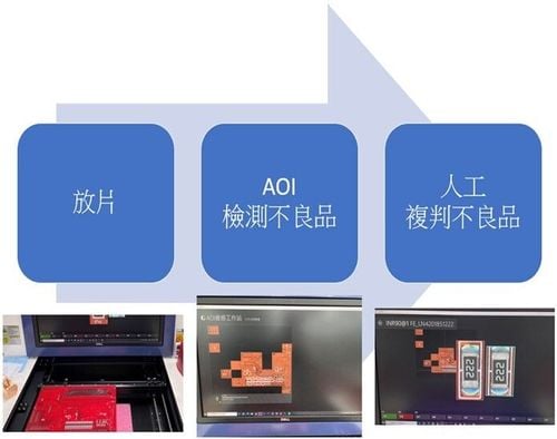
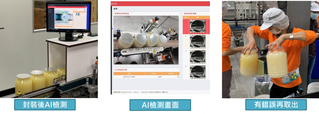
Smart sealing yield inspection, comprehensive review

Seal recognition system diagram

▲Schematic diagram of sealing film recognition system

ZeroDimension Tech Co., Ltd. combined its know-how in image-related AI systems with the system integration know-how of another well-known system integrator in the industry to jointly develop a "smart factory sealing yield inspection system," which was integrated and implemented in the process of coconut jelly manufacturers, increasing the coverage of product seal inspection.

Before utilizing the capabilities of AI, the original production line produced 100 boxes (about 600 cans) with a yield of 95%, meaning that there are about 30 defective cans. However, since the inspection coverage was only 2.5%, only 1 defective can was detected. However, after utilizing AI for inspection, the inspection coverage rate increased to 96%, meaning that about 28 defective cans can be detected, greatly increasing the detection rate of defective products, thereby reducing potential losses in the future.

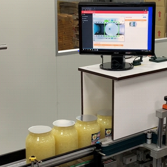
Whether it adds value as an add-on or is built-in, it can provide solutions for the industry

Inspection service process diagram

▲Schematic diagram of inspection service process

This sealing film inspection system service framework can be implemented into the quality control inspection of other similar inspection processes in the form of an add-on in the future, such as: integrated into the film sealing production process of beverage factories and other canned products. It can also integrate software and hardware with sealing machine hardware manufacturers to add value to sealing machines using the build-in model, providing the industry with total solutions.

Recommend Cases

【解決方案】優式AI智能割草機器人 搶攻高爾夫藍海市場
USRROBOT's AI Lawn Mowing Robot Enters the Blue Ocean of Golf Market

An AI smart lawn mowing robot, resembling a vacuum robot, shuttles back and forth on the 30-hectare golf course lawn for weeding This robot, independently developed and designed by Taiwanese, is equipped with the world's first electronic fencing positioning technology which utilizes high-precision GPS integrated with cloud AI computation to determine the most efficient mowing paths, targeting the lucrative blue ocean market of golf courses This AI lawn mowing robot was developed by USRROBOT, a Taiwanese startup established in 2019 Chao-Cheng Chen, the president of USRROBOT, once served as the executive vice president of one of the top five ODM tech companies in Taiwan, and specializes in software and hardware integration When he served as the chairman of the Service Robot Alliance, he knew that the service robot industry was bound grow rapidly due to declining birth rates and the growingly severe labor shortage New demand - The horticulture market is large and the has rigid demand "To develop the core technology of service robots, we must find rigid demand Looking at European and American countries, there is a shortage of labor, but demand for horticulture has increased, and there has been a long-term shortage of 7-10 of horticultural workers" Under this strong "rigid demand," Chao-Cheng Chen established USRROBOT, and the company's first product is the AI lawn mowing robot In terms of overseas markets, the United States is the world's largest horticulture market, accounting for 30-40 of the global output value It is estimated that there are about 1 million horticulture workers, but they have been experiencing a labor shortage of 7-10 in recent years and have not been able to improve the situation The main reasons for labor shortage are Aging population and gardening is a labor-intensive job, so young people don't want to do it Unlike in Taiwan, European and American countries attach great importance to lawn maintenance and have expressly stipulated in the law that heavy fines will be imposed for failing to mow the lawn Therefore, the AI lawn mowing robot has considerable market development potential The introduction of AI multi-device collaborative mowing sensor technology is expected to reduce the burden of staff maintaining the golf course The AI lawn mowing robot developed by USRROBOT is currently in its second generation Domestic universities and well-known art museums are using the latest model M1, and it is also being used by some world-renowned high-tech companies and well-known universities in the United States The company is currently involved in negotiations for subsequent business cooperation USRROBOT stated that the professional RTK system currently used can reduce the original GPS positioning error from tens of meters to about 2 centimeters, allowing the robot to move accurately outdoors After setting the boundaries, it can be easily operated using the app New application - Implementation in golf courses solves the problem of labor aging and shortage Chao-Cheng Chen further explained that the National Land Surveying and Mapping Center is a RTK service provider RTK provides the error reference map of the positioning point USRROBOT can access the positioning error value of a specific position through 4G Internet access The AI algorithm of USRROBOT reduces the general 10-20 m error of GPS to 2 cm After positioning, USRROBOT then uses six-axis accelerator positioning, gyroscopes, and wheel differential sensing devices for software and hardware integration Only by matching the wheel's movement pattern and the terrain can accurate mowing path planning be achieved The AI lawn mowing robot, which is 62 cm wide, 84 cm long, 46 cm high, and weighs only 25 kg, can set the mowing boundaries in the cloud It can avoid pools and sand pits through settings, using AI algorithms to automatically calculate the optimal path It is able to mow approximately 150 ping of grass in one hour The battery can be used continuously for more than 6 hours The battery life is currently the highest in the world In addition to general gardening companies, with the assistance of the AI project team of the Industrial Development Bureau, Ministry of Economic Affairs, USRROBOT's AI lawn mowing robot has been applied to golf course lawn mowing A well-known golf course located in Taiping District, Taichung City currently has a staff of 5 people who are responsible for the lawn, planting maintenance, and other landscape maintenance of the entire 30-hectare course However, the average age of staff is as high as 55 years old, and the golf course has been unable to recruit new staff members for a long time In view of the aging staff and the shortage of manpower, the golf course hopes to mitigate the impact with AI technology, and is therefore using AI multi-device collaborative mowing sensor technology, in hopes of reducing the burden of staff maintaining the golf course New challenges - Expert systems are needed to overcome difficulties with different grass species "This AI lawn mowing robot has low noise, low pollution, low labor costs, and is waterproof and anti-theft In the lawn mowing process, it can identify and avoid obstacles through ultrasonic sensors while maintaining mowing quality, maintaining aesthetic and consistent grass length" Chao-Cheng Chen went on to say that the most important part about golf courses is that the grass pattern should be beautiful and free from diseases and pests Based on the site survey, golf courses are mainly divided into three major areas green, fairway and rough There is no problem using the current mowing robot to mow the rough area, and it can overcome slopes within 20 degreesThe short grass in the fairway area may only be two centimeters long, and the grass types are also different, so the cutterhead design needs to be modifiedAs for the grass in the green area, the grass must be mowed close to the ground and maintained in a consistent direction because it affects the putting speed Many factors will affect the green index, and this part requires more research and testing The AI lawn mowing robot can identify and avoid obstacles through ultrasonic sensors while maintaining mowing quality The AI smart lawn mowing robot has a built-in camera that can be used to detect the health condition of the lawn Chao-Cheng Chen said that in the future, an expert system will also be introduced for early determination of whether there are diseases, pests in the lawn or whether there is sufficient moisture, and provide lawn health data analysis to customers, so that they can take preventive and response measures sooner to reduce disaster losses Chao-Cheng Chen, who is also a good golfer himself, said that golf has developed well in Taiwan However, due to weather factors, such as rainy and humid climate and typhoons, Taiwan's golf courses have harder soil and more potholes compared with top tier golf courses overseas If AI lawn mowing robots are to be widely introduced into golf courses, there are still many difficulties that must be overcome However, Taiwan's difficult terrain creates a good testing ground Once Taiwan can overcome the many problems and successfully introduce the robot, it will be able to expand to overseas markets and seize new market opportunities in a blue ocean Chao-Cheng Chen, President of USRROBOT nbsp

【導入案例】巨量遙測空間數據AI分析雲端服務平台 使衛星遙測影像順利落地應用
AI Analysis Cloud Service Platform for Remote Sensing Big Data Enables the Smooth Application of Satellite Remote Sensing Images

Although satellite remote sensing images can make all surface objects visible, it still requires a lot of time and manpower to be truly applied to the industry In order to effectively solve the problems that customers face in digesting huge amounts of image data and eliminate technical obstacles for cross-domain users to process satellite remote sensing images, ThinkTron has developed an "AI Analysis Cloud Service Platform for Remote Sensing Big Data" as a new beginning for cross-domain AI applications for spatial information In recent years, in response to the impact of industrial globalization, Taiwan's agriculture has continued to transition towards technology-based and higher quality, improving the yield and quality of crops by solving problems, such as microclimate impacts and pest and disease control The demand of agriculture on images has expanded endlessly to accurately grasp the growing environment of crops In the early years when UAVs unmanned aerial vehicles were not yet popular, manual field surveys were the most basic but most labor-intensive work With the emergence of UAV drones, aerial photography operations might not be difficult, but the range that can be photographed is limited Furthermore, surveying expertise is required to accurately capture spatial information At this time, the use of satellite remote sensing data may break away from the past imagination of using image data Taiwan Space Agency TASA ODC data warehouse services In the past ten years, with the breakthrough of modern satellite remote sensing application technology, Digital Earth has become a new trend in global data collection Countries have developed data cube image storage technology, and the development of smart agriculture has become one of the largest image users Determining planting distribution is the first step in understanding crop yields Free satellite remote sensing images, powerful data warehousing support, and the team's robust image recognition technology are important supports for accelerating agricultural transformation Using satellite remote sensing image data can accelerate the development of smart agriculture However, in the past, it was difficult to extract large-area crop distribution through satellite remote sensing images, not to mention the cost If you wanted to use free information, you had to visit all websites of international space agencies, look through the wide variety of satellite specifications, and carefully evaluate the sensor specifications, image resolution, and revisit cycle After finding suitable images, you had to look at them one by one to filter the ones you need Next is downloading dozens of images that are often several hundreds of Megabytes MB each, which might exceed the capacity of your computer Also, after overcoming image access and preparing data, you must then start to confirm the downloaded image products and which bands you want, because the image you see is not just an image file jpg or png, but rather complex multi-spectral information, attribute fields and coordinate information It takes a lot of effort just to confirm the correct information Facing GIS software packages with complex functions is the start of another trouble The complex image pre-processing process and the inflexible machine learning package greatly reduce the efficiency of analyzing data After finally getting the results of crop identification, you might find that the best time for using map information may have already passed The above-mentioned complex and time-consuming satellite image processing problems are precisely the pain points of the market ThinkTron expanded from traditional machine learning to modern deep learning applications, and developed an "AI Analysis Cloud Service Platform for Remote Sensing Big Data" under the GeoAI framework, breaking through the constraints of details in the spatial information for customers Differences between the process before and after introducing the AI analysis cloud service platform ThinkTron said that Taiwan's ODC Open Data Cube system has been completed and began providing services after years of efforts from the Taiwan Space Agency TASA, formally becoming aligned with international trends The powerful warehousing technology allows users to easily capture and use image data of a specific time and spatial range according to their needs The warehouse stores multiple satellite image resources from international space agencies, including the ESA's Sentinel-1 one image every 6 days, Sentinel-2 one image every 6 days, USGS's Landsat-7 one image every 16 days, Landsat-8 one image every 16 days, and the domestic Formosat-2 one image every day and Formosat-5 one image every 2 days ThinkTron develops satellite image recognition tools based on Python Breaking free from the limitations of GIS Geographic Information System software packages, ThinkTron integrated GDAL Geospatial Data Abstraction Library based on Python, and considered computing efficiency and parallel processing when developing all tools required for satellite image processing and image recognition modeling, including coordinate system and data format conversion, grid and vector data interaction, and data intra-difference and normalization All of the tools are designed with AI applications in mind, and some commonly used tools are packaged into an open source package under the name TronGisPy to benefit the technical community ThinkTron utilized the team's understanding of satellite remote sensing images and the collected tagged data crop distribution maps to preset the image recognition modeling process, the required training data specifications, and dataset definitions This is imported into the machine learning LightGBM or deep learning CNN framework that was completed in advance, and the entire training process to be performed in the Web GIS interface, providing users with partial flexibility to freely filter images, confirm spatial and temporal ranges, select models, and adjust hyperparameters In addition to the operation of training models, it also provides historical models to output identification results, and finally displays the identification results of crop distribution on the Web GIS map In fact, agriculture is not the only industry that needs satellite remote sensing applications AI applications of spatial information have also appeared in various fields as companies in different industries aim to enhance their global competitiveness For example, surveying and mapping companies that have a large amount of map data can use the AI analysis cloud service platform to store map data while also accelerating the efficiency of digital mapping Under the severe global climate change and the risk of strong earthquakes, there is a wide variety industrial insurance, agricultural insurance, financial insurance, or disaster insurance are all inseparable from spatial information The use of remote sensing image recognition to understand insurance targets has long been an international trend AI Analysis Cloud Service Architecture for Remote Sensing Big Data

這是一張圖片。 This is a picture.
AI Assists the Red Cross for Smarter Emergency Response

More Preparation Less Loss The Taiwan Food Bank Association, a non-profit organization, collects donations daily from wholesalers, retailers, manufacturers, and even kind-hearted individuals across Taiwan They also rescue consumable materials that are about to be discarded, properly allocate and deliver to households in need, aiding local underprivileged populations When natural disasters such as earthquakes, landslides, mudslides, typhoons, floods, and droughts occur in Taiwan, the food bank's resources can be immediately deployed for disaster relief This field verification unit is the Nantou County Red Cross AssociationOne of the food bank locations, hereinafter referred to as the Nantou Red CrossIs responsible for tasks like pre-disaster supplies preparation and disaster relief material distribution, helping the government bear the responsibility of disaster relief and aid In Taiwan, various natural disasters have characteristics of different duration and spatial coverage, wide or narrow With the normalization of extreme weather, the scale and number of disasters are gradually increasing and becoming harder to predict The required amount and type of materials differ by disaster, and they must address the lifestyles of the affected areas, rescue needs, traffic conditions, geographical restrictions, and other factors for varied material allocation, facing numerous challenges Typhoon Kanu severely damaged transportation in Nantou mountain areas Nantou County Red Cross planned the mountainous route Puli gt Fazhi Elementary School gt Qin'ai Village gt Aowanda to deliver supplies Disasters happen repeatedly We need to be prepared at all times Effective disaster preparedness can mitigate the impact, including swift response to material needs in affected areas, aid distribution, and even psychological support, providing added security for life and property of those in disaster zones Lack of Timeliness in Disaster Information To improve the living conditions and address the lack of supplies in remote areas, the Taiwan Food Bank Association has partnered with the Nantou Red Cross and has successively established food bank points in Nantou City, Puli, and Ren'aiLixing, Ruiyan, XinyiWangmei, Tongfu, Shuili, Lugu and Caotun among others9establish food bank locations, providing supplies worth a certain amount per household every month6001000in New Taiwan Dollars However, many challenges still need to be overcome during natural disasters For example, when typhoons, earthquakes, and landslides occur, the information source for disaster relief dispatch systems relies on post-disaster reports The time lag between reporting, response, and execution prevents timely adjustment and distribution of 'disaster relief' supplies based on the needs of affected areas, affecting rescue efficiency due to lack of timely information The 'preparedness' supplies of the Nantou Red Crosssuch as dry food, water, instant noodles, etc,are recorded manually in terms of stock, expiration dates, and distribution,When a disaster occurs, there is a chance that 'preparedness' supplies have expired and cannot become 'disaster relief' supplies It’s also possible that both conditions mentioned above occur simultaneously, leading to a need for more time to reassign 'preparedness' supplies into usable 'disaster relief' materials On the other hand, upon receiving information about shortages in disaster areas, the supplies donated by the public often grossly differ from the actual needs of the disaster zone, leading to an excess of supplies The Process of Material Operations Before and After a Natural Disaster AIAnticipating Natural Disasters Reinforcing the Accuracy of Preparedness Material Dispatch Application API Technology connects to compute the state of the climate, the intensity of disaster rescues, prioritizing the main tasks of the Nantou Red Cross and the needed areas of search and rescue Coordinated with the existing heavy rain and typhoon simulation disaster training of the Nantou Red Cross, a 'Natural Disaster Emergency Preparedness Material Dispatch and Supplement Decision System' is establishedreferred to as the Emergency Preparedness Material System。 In material management, inventory data along with immediate supply data are entered into the Emergency Preparedness Material System for comparison and analysis, helping the Nantou Red Cross quickly recognize materials like cookiesdry food, beverages, frozen food, toilet paper, etc, and determining whether they should be 'preparedness' materials or regularly distributed materials Adding to this, information forecasting understands the potential disaster conditions in remote areas, facilitating food delivery, addressing both front-end food wastage and backend practical needs When a natural disaster occurs, it enables faster response and decision-making, completing material deployment, hence increasing the speed of material operation transition20。 AI Emergency Preparedness Material System Helps Rapidly Adapt Material Distribution Through the field verification of the Nantou Red CrossAIthe system, material management, and related applications are promoted to more emergency response organizations in different areas, while continuously improving the alert functions within the Emergency Preparedness Material System, strengthening the technological foundation for alerts, enhancing prediction accuracySystem immediacy, and optimizing the data collection and analysis process Simultaneously, it can collaborate with government agencies, meteorological departments, or other rescue teams to discuss integrating more data sources, establishing a mechanism to share resources and data promptly, sharing information in real-time, helping more emergency response organizations enhance their disaster response abilities, seizing the golden rescue time 「Translated content is generated by ChatGPT and is for reference only Translation date:2024-12-12」