:::

【2021 Application Example】 Hamastar Technology Builds an AI Model Management Platform to Accelerate the Application of AI

Riding the AI hype train, financial service providers are using their solid foundation in the industry to not only transform themselves, but also assist their customers with transformation!

Hamastar Technology, which has been established for over two decades, has been developing AI technology and assisting industry customers with the implementation of AI in recent years. Hamastar Technology believes that to implement a complete AI project, in addition to AI theoretical knowledge, data analysis, and model training capabilities, it is also necessary to develop APIs for data, establish databases, develop front-end RWD web pages, and even consider layout design and user experience based on customer needs. These tasks create technical barriers for AI startups. Even from the perspective of companies that have reached a certain scale, it is hard to accumulate technical experience and accelerate business growth due repeatedly investing manpower developing similar functions in each project.

Institutional customers still require high level of customization for AI

Using the requirements of government Agency A implemented by Hamastar Technology as an example, users must control false information from specific channels. The platform needs to provide data ingestion functions for training models and predictions, and can complete natural language processing (NLP) text classification model training and use. When the model discovers false information, it needs to immediately notify responsible personnel through messaging software. The need of Agency B is to use an AI model to automatically classify petitions and immediately provide information on past cases as reference for the petitioner or officer. Although the project models are similar (data ingestion, model prediction, warning / notification), the required functions still need to be separately developed for individual projects, and existing programs and models cannot be reused to speed up the implementation of subsequent projects.

After in-depth discussion, Hamastar Technology found that pain points of enterprises implementing AI projects include high implementation costs and lengthy project schedules. It is difficult for a single enterprise to simultaneously have data scientists, analysts, engineers, and designers. Current projects are all focused on solving the needs of specific fields, and it is difficult to reuse the AI models in other fields of application. At the same time, the tools are concentrated in AI projects and cannot provide customers with total solutions.

In other words, due to the "limited manpower," "restricted fields," and "insufficient tools" of AI service providers, the implementation of AI technology projects requires high costs or lengthy timelines. These are common problems that companies urgently need to solve. Therefore, if there is an AI model application service management platform, it will be able to solve the above difficulties and not only reduce costs, but also accelerate project implementation and provide customers with one-stop solutions.

AI model application service management platform assists in quickly completing projects

Therefore, with the support of the AI project of the Industrial Development Bureau, Ministry of Economic Affairs, Hamastar Technology carried out the "AI Model Application Service Management Platform (AISP) R&D Project" and engaged in the R&D of AISP products. The purpose is for AI service providers to complete the AI projects with twice the result using only half the effort.

The AI Model Application Service Management Platform offers AI-specific problem-solving solutions.

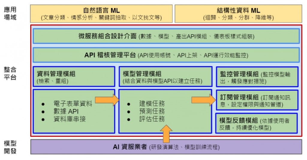
▲The AISP provides one-stop AI solutions

AI service providers can quickly assemble required functions, such as data API, model management, and model prediction result monitoring / subscription through existing module functions of the AISP. It also provides commonly used graphical tools to help companies quickly design interactive charts or dashboards required by users, effectively reducing the labor costs required to execute projects, shortening the solution POC or implementation time, and accelerating the implementation and diffusion of industry AI.

In terms of product business model, in the short term, the company will extensively invite IT service providers with expertise in the field of AI to work together, and use platform services to solve the AI implementation problems faced by requesting units in various field, gradually building trust in the platform brand. In the mid-term, the company hopes to gradually expand the market based on its past success, and form strategic alliances with multiple IT service providers to solve more and wider problems in specialized fields and provide more solutions for units to choose from.

The platform combines field experts to jointly expand overseas markets

In the long term, after establishing AI strategic alliances in various specialized fields, the platform will have a large number of AI solution experts for specialized fields. After accumulating a large amount of successful project experience, Hamastar Technology hopes that the AISP will be able to work with experts / companies to expand into the international market.

Harmastar Technology Co., Ltd. was formed in 2000 by recruiting numerous senior professional managers and technical experts in related fields. It is committed to software technology R&D and services, and aims to develop into an international software company, actively creating opportunities for international cooperation in the industry. Under the excellent leadership of its first president, the company has rapidly grown into a major software company in Taiwan.

Recommend Cases

【導入案例】巨量遙測空間數據AI分析雲端服務平台 使衛星遙測影像順利落地應用
AI Analysis Cloud Service Platform for Remote Sensing Big Data Enables the Smooth Application of Satellite Remote Sensing Images

Although satellite remote sensing images can make all surface objects visible, it still requires a lot of time and manpower to be truly applied to the industry In order to effectively solve the problems that customers face in digesting huge amounts of image data and eliminate technical obstacles for cross-domain users to process satellite remote sensing images, ThinkTron has developed an "AI Analysis Cloud Service Platform for Remote Sensing Big Data" as a new beginning for cross-domain AI applications for spatial information In recent years, in response to the impact of industrial globalization, Taiwan's agriculture has continued to transition towards technology-based and higher quality, improving the yield and quality of crops by solving problems, such as microclimate impacts and pest and disease control The demand of agriculture on images has expanded endlessly to accurately grasp the growing environment of crops In the early years when UAVs unmanned aerial vehicles were not yet popular, manual field surveys were the most basic but most labor-intensive work With the emergence of UAV drones, aerial photography operations might not be difficult, but the range that can be photographed is limited Furthermore, surveying expertise is required to accurately capture spatial information At this time, the use of satellite remote sensing data may break away from the past imagination of using image data Taiwan Space Agency TASA ODC data warehouse services In the past ten years, with the breakthrough of modern satellite remote sensing application technology, Digital Earth has become a new trend in global data collection Countries have developed data cube image storage technology, and the development of smart agriculture has become one of the largest image users Determining planting distribution is the first step in understanding crop yields Free satellite remote sensing images, powerful data warehousing support, and the team's robust image recognition technology are important supports for accelerating agricultural transformation Using satellite remote sensing image data can accelerate the development of smart agriculture However, in the past, it was difficult to extract large-area crop distribution through satellite remote sensing images, not to mention the cost If you wanted to use free information, you had to visit all websites of international space agencies, look through the wide variety of satellite specifications, and carefully evaluate the sensor specifications, image resolution, and revisit cycle After finding suitable images, you had to look at them one by one to filter the ones you need Next is downloading dozens of images that are often several hundreds of Megabytes MB each, which might exceed the capacity of your computer Also, after overcoming image access and preparing data, you must then start to confirm the downloaded image products and which bands you want, because the image you see is not just an image file jpg or png, but rather complex multi-spectral information, attribute fields and coordinate information It takes a lot of effort just to confirm the correct information Facing GIS software packages with complex functions is the start of another trouble The complex image pre-processing process and the inflexible machine learning package greatly reduce the efficiency of analyzing data After finally getting the results of crop identification, you might find that the best time for using map information may have already passed The above-mentioned complex and time-consuming satellite image processing problems are precisely the pain points of the market ThinkTron expanded from traditional machine learning to modern deep learning applications, and developed an "AI Analysis Cloud Service Platform for Remote Sensing Big Data" under the GeoAI framework, breaking through the constraints of details in the spatial information for customers Differences between the process before and after introducing the AI analysis cloud service platform ThinkTron said that Taiwan's ODC Open Data Cube system has been completed and began providing services after years of efforts from the Taiwan Space Agency TASA, formally becoming aligned with international trends The powerful warehousing technology allows users to easily capture and use image data of a specific time and spatial range according to their needs The warehouse stores multiple satellite image resources from international space agencies, including the ESA's Sentinel-1 one image every 6 days, Sentinel-2 one image every 6 days, USGS's Landsat-7 one image every 16 days, Landsat-8 one image every 16 days, and the domestic Formosat-2 one image every day and Formosat-5 one image every 2 days ThinkTron develops satellite image recognition tools based on Python Breaking free from the limitations of GIS Geographic Information System software packages, ThinkTron integrated GDAL Geospatial Data Abstraction Library based on Python, and considered computing efficiency and parallel processing when developing all tools required for satellite image processing and image recognition modeling, including coordinate system and data format conversion, grid and vector data interaction, and data intra-difference and normalization All of the tools are designed with AI applications in mind, and some commonly used tools are packaged into an open source package under the name TronGisPy to benefit the technical community ThinkTron utilized the team's understanding of satellite remote sensing images and the collected tagged data crop distribution maps to preset the image recognition modeling process, the required training data specifications, and dataset definitions This is imported into the machine learning LightGBM or deep learning CNN framework that was completed in advance, and the entire training process to be performed in the Web GIS interface, providing users with partial flexibility to freely filter images, confirm spatial and temporal ranges, select models, and adjust hyperparameters In addition to the operation of training models, it also provides historical models to output identification results, and finally displays the identification results of crop distribution on the Web GIS map In fact, agriculture is not the only industry that needs satellite remote sensing applications AI applications of spatial information have also appeared in various fields as companies in different industries aim to enhance their global competitiveness For example, surveying and mapping companies that have a large amount of map data can use the AI analysis cloud service platform to store map data while also accelerating the efficiency of digital mapping Under the severe global climate change and the risk of strong earthquakes, there is a wide variety industrial insurance, agricultural insurance, financial insurance, or disaster insurance are all inseparable from spatial information The use of remote sensing image recognition to understand insurance targets has long been an international trend AI Analysis Cloud Service Architecture for Remote Sensing Big Data

這是一張圖片。 This is a picture.
CCTV Intelligent Video Search System

Search for a specific person, find someone with a suitcase entering the factory in Gao'an area Color features of the person and the object confirmed, person in blue and black top, suitcase in black color, throughCCTV the intelligent video search system, by setting object and color retrieval conditions, it can successfully locate three video clips containing the target subject This greatly aids operational staff in finding the target items, and through this system, search speed can far surpass manual effort6fold Pain Points The CSE-Kaohsiung Plant is densely equippedCCTVto monitor every corner of the plant area, but when an incidenthappens, it's impossible within a limited time throughCCTVvideo playback to find the incident, the implications and risks behind this are self-evident Many areas that are usually unmanned can easily become security blind spots Thus, how to monitor a vast plant area more intelligently and effectively is one of the crucial aspects of building a smart plant for the semiconductor industry The AES Plant in Kaohsiung covers a vast area, with many important sites requiring monitoring of personnel movements to ensure corporate secrets and employee safety 1 Automated production lines and warehouses In semiconductor enterprises’ automated production lines and warehouses, oftenAGV(Automated Guided VehicleAGVs automated guided vehicles travel at high speeds if plant personnel inadvertently enterAGVthe moving area and cannot issue a warning to the person, then the regrettable accidents that occur will be too late to reverse 2 Material and product storage areas Materials used in semiconductor-related processes are costly if areas storing materials or products are breached, there is a risk of loss of high-value materialsproducts 3 High-security areas Trade secrets relate to the core technological competitiveness of semiconductor-related enterprises if someone breaches the high-security areas, there is a risk of corporate secrets being leaked The safety of trade secrets has always been one of the most critical issues for semiconductor enterprises 4 Loading docks At AESLButthe dock area often has loading vehicles coming and going if someone intrudes into the dock area, there is a risk of vehicle collisions and accidents Additionally, goods awaiting shipment at the dock area could be stolen or potentially damaged from collisions, thus causing significant reputation and financial losses for the company, further leading to production and shipping inconvenience When an abnormal event occurs, how to quickly search for the relevant key footage from massive data Many important locations within the AES Kaohsiung Plant need to be equippedCCTVfor safety checks, butCCTVWith thousands to tens of thousands of cameras, manually searching through footage for an event requires laborious frame-by-frame review which is time-consuming and inefficient In light of advancements in computer vision, it's beneficial to utilizeAIto replace manual playback and searching Problem Scenario Object Detection The data source for object detection comprises two parts Open-source datasetsOIDv4and AES Kaohsiung PlantCCTVImage files For these files, search for usable data, specificallyOIDv4image files For these files, extract the defined nine major categories of objects for training data among them, two object categories, knives and gasoline barrels, were not found inOIDv4found usable data for knives and gasoline barrels, while the remaining seven categories of objects are available fromOIDv4useful training data found for the remaining seven categories of objects, all marked Regarding the Kaohsiung PlantCCTVimage files, select some frames Frame of the footage, and manually annotate the objects to be_detected for training and testing data Nine Major Objects Color Recognition The data source for color recognition is divided into two partsInternet image screenshots, and Kaohsiung PlantCCTVimage files Currently, no publicly available open-source datasets specifically for color recognition applications have been found, so images are collected from the web Search the web for images of the defined nine major object categories, save the images after separating the objects from the background, keeping only the object sections, and mark the images according to color Additionally, for the Kaohsiung PlantCCTVimage files, use the already-markedbounding boxextractCCTVimage files from variousFramesections of objects identified by color, and finally, visually identifiable images are marked according to color Each object category has its specific color definition, depending on the usual colors seen in these objects in real life Dynamic Ignore during Training FromOIDv4during the training of the object detection pilot model, since each image in this dataset is only marked for a single category, but the image may contain other desired detection categories unmarked For such cases, dynamic ignore techniques will be employed during training to avoid confusion Next, use the extracted training data from the Kaohsiung Plant toFine-Tuneenhance the detection rate of the object in specific designated areas Finally, select the model that computes the lowest loss value in the test set during the training process as the main object_detection model Dynamic Ignoring AIHelp You View CCTV The intelligent video search system primarily serves as an assistive system for searching surveillance footage, capable of speeding up the process of finding target events by setting search conditions for objects By simply defining the search conditions, you can quickly produce thumbnails of critical objects and playback for review, shortening the time required for manual case retrieval of the past The search time is quickly6doubled, allowing the front-end security unit to use this platform to strengthen the first line of risk management supervision and take timely preventive measures 「Translated content is generated by ChatGPT and is for reference only Translation date:2024-12-12」

【導入案例】赫銳特科技VCSEL封裝元件瑕疵導入AOI檢測 提升產能效率20
HRT Technology Improves Production Efficiency by 20% Through AOI Detection of Defects in VCSEL Packaging

In 2017, the launch of the iPhone X made 3D sensor technology used in Face ID highly popular, which drove the development of VCSEL, a core component in the 3D sensor module In the detection of defects in incoming packaged VCSEL, the use of AI inference models can solve the industry's issue with low yield and improve reliability to 95 VCSEL technology currently can be used in many applications and various end consumer markets, including robots, mobile devices, surveillance, drones, and ARVR VCSELs are a good solution in applications that require high-speed modulation capabilities, such as cameras and biometrics VCSEL technology has a wide range ofnbsp applications, including in drones Pictured Zoyi Technology's Agricultural Drone VCSEL technology has a wide range of applications, AI technology assists in defect detection HRT Technology stated that the packaged VCSEL market is also facing strong price competition from competitors, and needs to further reduce costs and enhance product competitiveness One of the key problems is the replacement of glass lens with epoxy resin lens The production of traditional glass lenses has high yield, but the cost is higher than that of epoxy resin lenses Due to the cutting process of epoxy resin, the side wall of cutting lines can easily have rough edges, causing it to be oversized The release of stress caused by heat during the mounting process will directly cause the optical lens to break HRT Technology pointed out that the incoming inspection of VCSEL epoxy resin lenses is very important Under the constraints of packaging space, the space for fitting the package and optical lens is limited Moreover, the optical lenses will be confined to a metal frame If the dimensional tolerances are properly controlled, stress release due to heat during mounting can easily cause the optical lens to break, resulting in a yield loss of up to 10 in the VCSEL package reliability verification, resulting in an increase in production costs In order to solve the problems above, HRT Technology hopes to use AI to monitor the size and appearance defects of epoxy resin components in the VCSEL epoxy resin lens incoming stage, verifying whether their dimensions meet specifications, whether the cutting edges are smooth, and whether there are any defects in their appearance Since traditional incoming material inspection requires a rough visual inspection by humans to distinguish the quality The problem of image collection needs to be solved first to successfully collect image data Therefore, HRT Technology first developed an Automated Optical Inspection AOI device, which includes X, Y, Z three-axis motion, high-resolution cameras, and related control software to automatically record images After collecting the image data, opencv aligns the test image and a normal image to determine differences between the two images, and then pixel mapping is used to compare the pixel area to complete initial screening Manual labeling is carried out according to the image classification above, including samples that are normal, have defects in appearance, or have different shape characteristics, and then algorithm training and verification is carried out Residual neural network ResNet or other related algorithms are used for deep learning to identify the quality of lenses Implementation of AOI inspection improves production efficiency by 20 and above Comparing the differences before and after the implementation of AI image inspection, the incoming VCSEL lens inspection before implementation only involved manual inspection of the appearance The lens is packaged on the VCSEL package that has completed die bonding After passing the general light up test, the final reliability test high temperature reflow is performed Failed samples go into the rework process However, after the implementation of AOI inspection, it can screen defective lenses sooner and reduce the cost of subsequent materials input, it can also reduce the need for rework due to failure, improving yield to 95 and above in the reliability verification This is expected to help companies reduce production costs by 10 and increase production efficiency by 20 and above The difference before and after implementing AI image detection HRT Technology pointed out that this technology is an AI application developed based on tiny images It uses deep learning algorithms to identify defects in the images The trained network automatically classifies image data to predetermined categories Defect categories can be determined through reference images, so cumbersome programming is not required In the industrial machine vision environment, deep learning is mainly used for classification tasks in applications, such as inspection of industrial products or identification of parts In the future, with the development of IoT wearable devices and the trend of energy saving, the size of optoelectronic components will continue to shrink This technology can be applied to the detection of defects in the appearance of other tiny optoelectronic components in the future